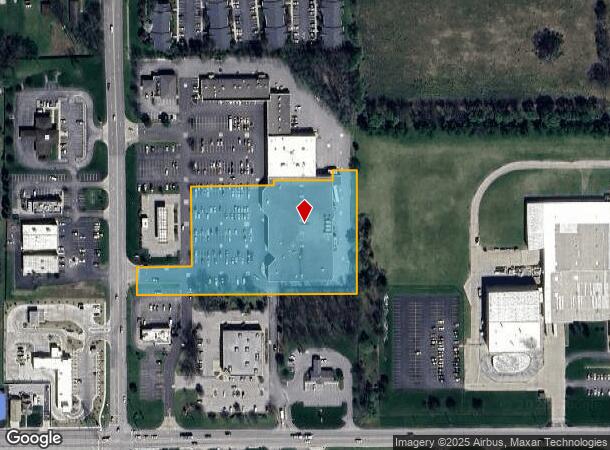
Property Record
306 N Bittersweet Rd, Mishawaka, IN 46544
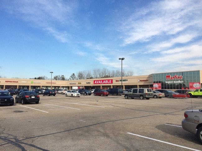
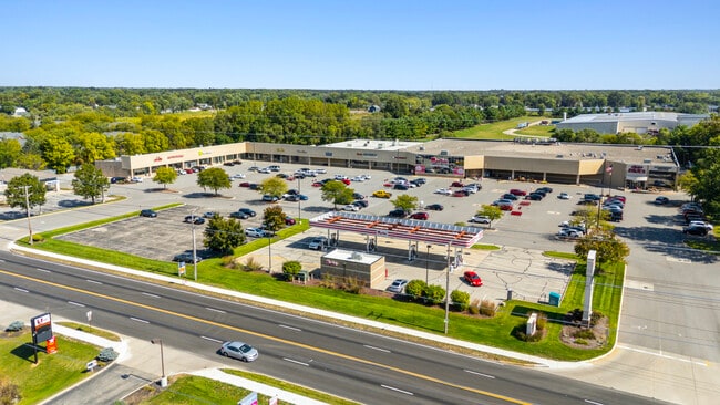
This Property Is For Sale
NEARBY LISTINGS FOR SALE OR LEASE
-
-
No Photo
-
View all Mishawaka listings for sale on LoopNet.com
Property Detail
306 N Bittersweet Rd
South Bend-Mishawaka, IN-MI
Bittersweet Plaza Minor Sub
71-10-18-201-001.000-022
LOT 1 BITTERSWEET PLAZA MINOR SUB 22/23 NP #3323 10/22/21
Regionalshoppingcenterormallwithanchorstore
St Joseph
X
Indiana
18141C0236E
1
2023
44 SF
2024
Mishawaka
011602
South Bend/Mishawaka
55,428 SF
DEMOGRAPHICS near 306 N Bittersweet Rd
1 Mile
3 Mile
5 Mile
2024 Total Population
4,642
29,860
83,944
2029 Population
4,592
29,506
83,339
Pop Growth 2024-2029
(1.08%)
(1.19%)
(0.72%)
Average Age
40
40
39
2024 Total Households
1,859
11,570
34,736
HH Growth 2024-2029
(1.18%)
(1.27%)
(0.67%)
Median Household Inc
$71,353
$71,606
$60,803
Avg Household Size
2.50
2.50
2.30
2024 Avg HH Vehicles
2.00
2.00
2.00
Median Home Value
$173,063
$170,992
$163,268
Median Year Built
1971
1973
1974
Nearby Places
- Restaurants
- Banks
- Shops
- Fitness
- Groceries
PUBLIC TRANSPORTATION
COMMUTER RAIL
Elkhart Amtrak Station (Capitol Limited - Amtrak, Lake Shore Limited - Amtrak)
DRIVE
WALK
Distance
Elkhart Amtrak Station (Capitol Limited - Amtrak, Lake Shore Limited - Amtrak)
13 min
7.5 mi
AIRPORT
South Bend International
DRIVE
WALK
Distance
South Bend International
31 min
14.5 mi
Freight Ports
Port Milwaukee
DRIVE
WALK
Distance
Port Milwaukee
228 min
190.4 mi
Nearby Properties
Address
Land Use
TOTAL SIZE
Lot Size
Zoning
Address
Land Use
TOTAL SIZE
Lot Size
Zoning
2,584,820 SF
32.18 AC
Address
Land Use
TOTAL SIZE
Lot Size
Zoning
184,212 SF
23.71 AC
ZO01
Address
Land Use
TOTAL SIZE
Lot Size
Zoning
36,851 SF
22.72 AC
Address
Land Use
TOTAL SIZE
Lot Size
Zoning
3,692,640 SF
0.01 AC
Address
Land Use
TOTAL SIZE
Lot Size
Zoning
386,403 SF
23.89 AC
Address
Land Use
TOTAL SIZE
Lot Size
Zoning
123,595 SF
7.92 AC
Address
Land Use
TOTAL SIZE
Lot Size
Zoning
115,990 SF
11.91 AC
Address
Land Use
TOTAL SIZE
Lot Size
Zoning
35,066 SF
2.63 AC
Address
Land Use
TOTAL SIZE
Lot Size
Zoning
81,185 SF
23.42 AC
Address
Land Use
TOTAL SIZE
Lot Size
Zoning
161,119 SF
44 SF
Address
Land Use
TOTAL SIZE
Lot Size
Zoning
279,230 SF
27.20 AC
Address
Land Use
TOTAL SIZE
Lot Size
Zoning
113,760 SF
44 SF
Address
Land Use
TOTAL SIZE
Lot Size
Zoning
220,647 SF
22.46 AC
Address
Land Use
TOTAL SIZE
Lot Size
Zoning
225,200 SF
25.73 AC
Address
Land Use
TOTAL SIZE
Lot Size
Zoning
137,368 SF
87 SF
Address
Land Use
TOTAL SIZE
Lot Size
Zoning
49,293 SF
87 SF
Address
Land Use
TOTAL SIZE
Lot Size
Zoning
30,470 SF
20 AC
Address
Land Use
TOTAL SIZE
Lot Size
Zoning
47,240 SF
6.66 AC
Address
Land Use
TOTAL SIZE
Lot Size
Zoning
281,499 SF
21.32 AC
Address
Land Use
TOTAL SIZE
Lot Size
Zoning
42,500 SF
1.93 AC
Address
Land Use
TOTAL SIZE
Lot Size
Zoning
109,536 SF
106 AC
Address
Land Use
TOTAL SIZE
Lot Size
Zoning
59,438 SF
10.73 AC
Address
Land Use
TOTAL SIZE
Lot Size
Zoning
30,344 SF
7.94 AC
Address
Land Use
TOTAL SIZE
Lot Size
Zoning
40,480 SF
3.62 AC
Address
Land Use
TOTAL SIZE
Lot Size
Zoning
61,384 SF
5.59 AC
Address
Land Use
TOTAL SIZE
Lot Size
Zoning
75,000 SF
44 SF
Address
Land Use
TOTAL SIZE
Lot Size
Zoning
31,156 SF
4.93 AC
Address
Land Use
TOTAL SIZE
Lot Size
Zoning
25,588 SF
12 AC
Address
Land Use
TOTAL SIZE
Lot Size
Zoning
33,330 SF
4.27 AC
The World's #1 Commercial Real Estate Marketplace
Connect with us
© 2025 CoStar Group
The information above has been obtained from sources believed reliable. While we do not doubt its accuracy we have not verified it and make no guarantee, warranty or representation about it. It is your responsibility to independently confirm its accuracy and completeness. Any projections, opinions, assumptions, or estimates used are for example only and do not represent the current or future performance of the property. The value of this transaction to you depends on tax and other factors which should be evaluated by your tax, financial, and legal advisors. You and your advisors should conduct a careful, independent investigation of the property to determine to your satisfaction the suitability of the property for your needs.