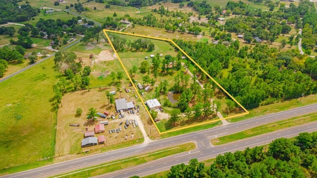
Property Record
3060 State Highway 19, Huntsville, TX 77320
NEARBY LISTINGS FOR SALE OR LEASE
Property Detail
3060 State Highway 19
11551
Crane J (A-14)
Sfr
CRANE J (A-14), TRACT 6.2, ACRES 7.25
X
Walker
48471C0275D
Texas
2024
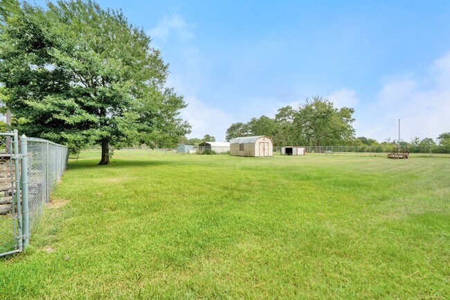
7.25 AC
2024
Texas East Area
790103
Other Market Areas
1,959 SF
Huntsville, TX
DEMOGRAPHICS near 3060 State Highway 19
1 Mile
3 Mile
5 Mile
2024 Total Population
575
2,526
7,236
2029 Population
612
2,696
7,770
Pop Growth 2024-2029
+ 6.43%
+ 6.73%
+ 7.38%
Average Age
43
42
42
2024 Total Households
231
986
2,614
HH Growth 2024-2029
+ 6.49%
+ 7.30%
+ 8.03%
Median Household Inc
$47,500
$53,727
$61,361
Avg Household Size
2.50
2.50
2.50
2024 Avg HH Vehicles
2.00
2.00
2.00
Median Home Value
$126,316
$142,266
$152,080
Median Year Built
1993
1991
1991
Nearby Places
- Restaurants
- Banks
- Shops
- Fitness
- Groceries
SALE & LEASE HISTORY
LISTING DATE
SALE/LEASE

Sep 17, 2021
For Sale
Sep 05, 2023
For Sale
Sep 01, 2022
For Lease
Nearby Properties
Address
Land Use
TOTAL SIZE
Lot Size
Zoning
Address
Land Use
TOTAL SIZE
Lot Size
Zoning
51,390 SF
4.05 AC
Address
Land Use
TOTAL SIZE
Lot Size
Zoning
10,488 SF
5 AC
Address
Land Use
TOTAL SIZE
Lot Size
Zoning
9,905 SF
761.52 AC
Address
Land Use
TOTAL SIZE
Lot Size
Zoning
53,775 SF
5 AC
Address
Land Use
TOTAL SIZE
Lot Size
Zoning
54,560 SF
6 AC
Address
Land Use
TOTAL SIZE
Lot Size
Zoning
5.31 AC
Address
Land Use
TOTAL SIZE
Lot Size
Zoning
27,865 SF
1.26 AC
Address
Land Use
TOTAL SIZE
Lot Size
Zoning
24,394 SF
3.92 AC
Address
Land Use
TOTAL SIZE
Lot Size
Zoning
5,768 SF
108 AC
Address
Land Use
TOTAL SIZE
Lot Size
Zoning
54,813 SF
3.52 AC
Address
Land Use
TOTAL SIZE
Lot Size
Zoning
7,374 SF
46.70 AC
Address
Land Use
TOTAL SIZE
Lot Size
Zoning
600 SF
10.96 AC
Address
Land Use
TOTAL SIZE
Lot Size
Zoning
2,256 SF
10 AC
Address
Land Use
TOTAL SIZE
Lot Size
Zoning
4,571 SF
5.73 AC
Address
Land Use
TOTAL SIZE
Lot Size
Zoning
4,434 SF
100.61 AC
Address
Land Use
TOTAL SIZE
Lot Size
Zoning
660 SF
2.86 AC
Address
Land Use
TOTAL SIZE
Lot Size
Zoning
18,976 SF
5 AC
Address
Land Use
TOTAL SIZE
Lot Size
Zoning
2,524 SF
11.27 AC
Address
Land Use
TOTAL SIZE
Lot Size
Zoning
1,600 SF
2.48 AC
Address
Land Use
TOTAL SIZE
Lot Size
Zoning
5,484 SF
7.35 AC
Address
Land Use
TOTAL SIZE
Lot Size
Zoning
4,069 SF
18.62 AC
Address
Land Use
TOTAL SIZE
Lot Size
Zoning
4,900 SF
30.70 AC
Address
Land Use
TOTAL SIZE
Lot Size
Zoning
3,332 SF
124.32 AC
Address
Land Use
TOTAL SIZE
Lot Size
Zoning
2,820 SF
10 AC
Address
Land Use
TOTAL SIZE
Lot Size
Zoning
3,184 SF
15.27 AC
Address
Land Use
TOTAL SIZE
Lot Size
Zoning
2,734 SF
9.03 AC
Address
Land Use
TOTAL SIZE
Lot Size
Zoning
2,654 SF
37.70 AC
Address
Land Use
TOTAL SIZE
Lot Size
Zoning
5,539 SF
4.41 AC
Address
Land Use
TOTAL SIZE
Lot Size
Zoning
2,859 SF
5 AC
The World's #1 Commercial Real Estate Marketplace
Connect with us
© 2025 CoStar Group
The information above has been obtained from sources believed reliable. While we do not doubt its accuracy we have not verified it and make no guarantee, warranty or representation about it. It is your responsibility to independently confirm its accuracy and completeness. Any projections, opinions, assumptions, or estimates used are for example only and do not represent the current or future performance of the property. The value of this transaction to you depends on tax and other factors which should be evaluated by your tax, financial, and legal advisors. You and your advisors should conduct a careful, independent investigation of the property to determine to your satisfaction the suitability of the property for your needs.