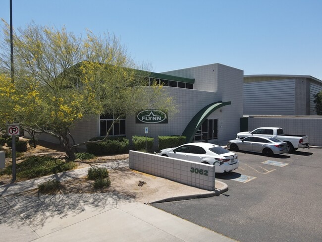
Property Record
3062 N Maple, Mesa, AZ 85215

Property Detail
3062 N Maple
141-25-074
COMMONS INDUSTRIAL PARK AT FALCON VIEW UNIT 1 MCR 446-34
Warehouse
Maricopa
I-1
Arizona
AH Areas with a 1% annual chance of shallow flooding, usually in the form of a pond, withan average depth ranging from 1 to 3 feet. These areas have a 26% chance of flooding over the life of a 30-year mortgage.
13
2025
2.30 AC
2025
Falcon Fld/Apache Jct
420304
Phoenix
32,698 SF
Phoenix-Mesa-Chandler, AZ
NEARBY LISTINGS FOR SALE OR LEASE
DEMOGRAPHICS near 3062 N Maple
1 mile
3 mile
5 mile
2025 Total Population
2,350
42,194
175,890
2030 Population
2,451
43,927
183,269
Pop Growth 2025-2030
+ 4.30%
+ 4.11%
+ 4.20%
Average Age
37
42
44
2025 Total Households
743
15,369
70,018
HH Growth 2025-2030
+ 4.31%
+ 4.54%
+ 4.66%
Median Household Inc
$164,583
$111,687
$81,793
Avg Household Size
3.10
2.70
2.40
2025 Avg HH Vehicles
2.00
2.00
2.00
Median Home Value
$730,769
$565,390
$416,562
Median Year Built
2010
1991
1986
Nearby Places
Map Layers
Map Styles
 Street
 Aerial
Transit
 Traffic
 Biking
Places
Listings with unknown addresses are not visible on the map
- Restaurants
- Banks
- Shops
- Fitness
- Groceries
PUBLIC TRANSPORTATION
AIRPORT
Phoenix-Mesa Gateway
Drive
Walk
Distance
Phoenix-Mesa Gateway
31 min
16.3 mi
Phoenix Sky Harbor International
Drive
Walk
Distance
Phoenix Sky Harbor International
27 min
17.0 mi
SALE & LEASE HISTORY
LISTING DATE
SALE/LEASE

Oct 06, 2020
For Lease
Jun 04, 2024
For Sale
Apr 20, 2020
For Sale
Nearby Properties
Address
Land Use
TOTAL SIZE
Lot Size
Zoning
Address
Land Use
TOTAL SIZE
Lot Size
Zoning
181.80 AC
Address
Land Use
TOTAL SIZE
Lot Size
Zoning
125,356 SF
21.63 AC
R-9
Address
Land Use
TOTAL SIZE
Lot Size
Zoning
1,691,248 SF
528.80 AC
I-1
Address
Land Use
TOTAL SIZE
Lot Size
Zoning
29.74 AC
Address
Land Use
TOTAL SIZE
Lot Size
Zoning
22.19 AC
Address
Land Use
TOTAL SIZE
Lot Size
Zoning
1,217,466 SF
102.41 AC
I-1
Address
Land Use
TOTAL SIZE
Lot Size
Zoning
11,722 SF
182.53 AC
PS
Address
Land Use
TOTAL SIZE
Lot Size
Zoning
400,798 SF
55.94 AC
PF
Address
Land Use
TOTAL SIZE
Lot Size
Zoning
22.71 AC
Address
Land Use
TOTAL SIZE
Lot Size
Zoning
20.08 AC
Address
Land Use
TOTAL SIZE
Lot Size
Zoning
161,388 SF
32.52 AC
R-35
Address
Land Use
TOTAL SIZE
Lot Size
Zoning
66,350 SF
22.32 AC
I-1
Address
Land Use
TOTAL SIZE
Lot Size
Zoning
158,514 SF
21.39 AC
Address
Land Use
TOTAL SIZE
Lot Size
Zoning
359,204 SF
40.94 AC
LI
Address
Land Use
TOTAL SIZE
Lot Size
Zoning
4.79 AC
Address
Land Use
TOTAL SIZE
Lot Size
Zoning
225,233 SF
21.66 AC
C-G
Address
Land Use
TOTAL SIZE
Lot Size
Zoning
125,534 SF
19.59 AC
I-2
Address
Land Use
TOTAL SIZE
Lot Size
Zoning
81,000 SF
15.70 AC
AG
Address
Land Use
TOTAL SIZE
Lot Size
Zoning
146,107 SF
10.12 AC
LI
Address
Land Use
TOTAL SIZE
Lot Size
Zoning
157,048 SF
10.75 AC
Address
Land Use
TOTAL SIZE
Lot Size
Zoning
113,207 SF
6.87 AC
C-G
Address
Land Use
TOTAL SIZE
Lot Size
Zoning
157,592 SF
6.31 AC
C-G
Address
Land Use
TOTAL SIZE
Lot Size
Zoning
209,538 SF
13.47 AC
M-M
Address
Land Use
TOTAL SIZE
Lot Size
Zoning
168,861 SF
66.90 AC
R-90
Address
Land Use
TOTAL SIZE
Lot Size
Zoning
304.07 AC
GI
Address
Land Use
TOTAL SIZE
Lot Size
Zoning
72,598 SF
38.83 AC
AG
Address
Land Use
TOTAL SIZE
Lot Size
Zoning
70,871 SF
9.95 AC
I-1
Address
Land Use
TOTAL SIZE
Lot Size
Zoning
133,219 SF
8.65 AC
I-1
Address
Land Use
TOTAL SIZE
Lot Size
Zoning
10 SF
0.91 AC
AG
Address
Land Use
TOTAL SIZE
Lot Size
Zoning
191,871 SF
9.51 AC
M-H
The World's #1 Commercial Real Estate Marketplace
Connect with us
© 2026 CoStar Group
The information above has been obtained from sources believed reliable. While we do not doubt its accuracy we have not verified it and make no guarantee, warranty or representation about it. It is your responsibility to independently confirm its accuracy and completeness. Any projections, opinions, assumptions, or estimates used are for example only and do not represent the current or future performance of the property. The value of this transaction to you depends on tax and other factors which should be evaluated by your tax, financial, and legal advisors. You and your advisors should conduct a careful, independent investigation of the property to determine to your satisfaction the suitability of the property for your needs.