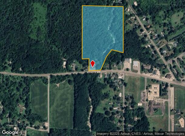
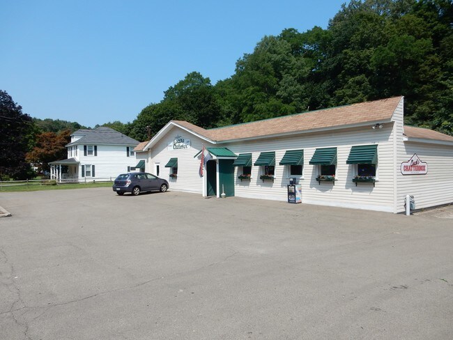
Property Record
3062 Route 430, Bemus Point, NY 14712

NEARBY LISTINGS FOR SALE OR LEASE
Property Detail
3062 Route 430
Jamestown-Dunkirk-Fredonia, NY
OLD APN: 063689 19-1-46.1
063689-368-000-0001-009-000
Chautauqua
Residentialacreage
New York
2025
9.000
2024
19.30 AC
036902
New York West Area
2,248 SF
Other Market Areas
DEMOGRAPHICS near 3062 Route 430
1 Mile
3 Mile
5 Mile
2024 Total Population
674
9,956
38,249
2029 Population
673
9,965
37,709
Pop Growth 2024-2029
(0.15%)
+ 0.09%
(1.41%)
Average Age
47
47
43
2024 Total Households
298
4,389
16,869
HH Growth 2024-2029
0.00%
+ 0.09%
(1.46%)
Median Household Inc
$70,833
$54,731
$41,556
Avg Household Size
2.20
2.20
2.20
2024 Avg HH Vehicles
2.00
2.00
1.00
Median Home Value
$209,000
$133,584
$88,832
Median Year Built
1968
1958
1949
Nearby Places
- Restaurants
- Banks
- Shops
- Fitness
- Groceries
SALE & LEASE HISTORY
LISTING DATE
SALE/LEASE

Sep 07, 2017
For Sale
Nearby Properties
Address
Land Use
TOTAL SIZE
Lot Size
Zoning
Address
Land Use
TOTAL SIZE
Lot Size
Zoning
130,937 SF
8.60 AC
07 - MIXED
Address
Land Use
TOTAL SIZE
Lot Size
Zoning
Address
Land Use
TOTAL SIZE
Lot Size
Zoning
259,898 SF
50.60 AC
Address
Land Use
TOTAL SIZE
Lot Size
Zoning
197,094 SF
25.10 AC
05 - COMME
Address
Land Use
TOTAL SIZE
Lot Size
Zoning
114,938 SF
10.40 AC
02 - SINGL
Address
Land Use
TOTAL SIZE
Lot Size
Zoning
68,967 SF
3.80 AC
05 - COMME
Address
Land Use
TOTAL SIZE
Lot Size
Zoning
Address
Land Use
TOTAL SIZE
Lot Size
Zoning
90,334 SF
54.50 AC
04 - FARM
Address
Land Use
TOTAL SIZE
Lot Size
Zoning
116,338 SF
15.40 AC
05 - COMME
Address
Land Use
TOTAL SIZE
Lot Size
Zoning
82,116 SF
6.55 AC
05 - COMME
Address
Land Use
TOTAL SIZE
Lot Size
Zoning
92,006 SF
12.30 AC
05 - COMME
Address
Land Use
TOTAL SIZE
Lot Size
Zoning
672,147 SF
48.40 AC
05 - COMME
Address
Land Use
TOTAL SIZE
Lot Size
Zoning
169,236 SF
11.80 AC
06 - INDUS
Address
Land Use
TOTAL SIZE
Lot Size
Zoning
2,484 SF
62.50 AC
04 - FARM
Address
Land Use
TOTAL SIZE
Lot Size
Zoning
Address
Land Use
TOTAL SIZE
Lot Size
Zoning
113,146 SF
13.40 AC
05 - COMME
Address
Land Use
TOTAL SIZE
Lot Size
Zoning
101,270 SF
8.70 AC
05 - COMME
Address
Land Use
TOTAL SIZE
Lot Size
Zoning
Address
Land Use
TOTAL SIZE
Lot Size
Zoning
23,127 SF
6.20 AC
05 - COMME
Address
Land Use
TOTAL SIZE
Lot Size
Zoning
0.11 AC
Address
Land Use
TOTAL SIZE
Lot Size
Zoning
40,973 SF
11.70 AC
05 - COMME
Address
Land Use
TOTAL SIZE
Lot Size
Zoning
27,808 SF
4.10 AC
06 - INDUS
Address
Land Use
TOTAL SIZE
Lot Size
Zoning
35,175 SF
4.16 AC
05 - COMME
Address
Land Use
TOTAL SIZE
Lot Size
Zoning
20,476 SF
2.20 AC
05 - COMME
Address
Land Use
TOTAL SIZE
Lot Size
Zoning
910 SF
20.20 AC
05 - COMME
Address
Land Use
TOTAL SIZE
Lot Size
Zoning
Address
Land Use
TOTAL SIZE
Lot Size
Zoning
13,836 SF
3.50 AC
03 - MULTI
Address
Land Use
TOTAL SIZE
Lot Size
Zoning
18,475 SF
8.20 AC
05 - COMME
Address
Land Use
TOTAL SIZE
Lot Size
Zoning
Address
Land Use
TOTAL SIZE
Lot Size
Zoning
10,320 SF
1.30 AC
05 - COMME
The World's #1 Commercial Real Estate Marketplace
Connect with us
© 2025 CoStar Group
The information above has been obtained from sources believed reliable. While we do not doubt its accuracy we have not verified it and make no guarantee, warranty or representation about it. It is your responsibility to independently confirm its accuracy and completeness. Any projections, opinions, assumptions, or estimates used are for example only and do not represent the current or future performance of the property. The value of this transaction to you depends on tax and other factors which should be evaluated by your tax, financial, and legal advisors. You and your advisors should conduct a careful, independent investigation of the property to determine to your satisfaction the suitability of the property for your needs.