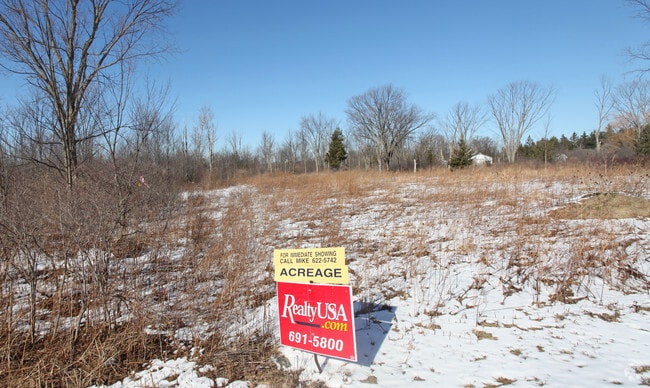
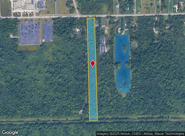
Property Record
3062 Staley Rd, Grand Island, NY 14072
NEARBY LISTINGS FOR SALE OR LEASE
-
-
View all Grand Island listings for sale on LoopNet.com
Property Detail
3062 Staley Rd
Buffalo-Cheektowaga-Niagara Falls, NY
6.2 AC
144600-050-000-0001-003-120
Erie
Residentialacreage
New York
X
3.120
36029C0020J
6.20 AC
2025
North
2024
Buffalo/Niagara Falls
007305
DEMOGRAPHICS near 3062 Staley Rd
1 Mile
3 Mile
5 Mile
2024 Total Population
479
11,221
23,716
2029 Population
480
11,257
23,780
Pop Growth 2024-2029
+ 0.21%
+ 0.32%
+ 0.27%
Average Age
45
43
43
2024 Total Households
191
4,759
9,710
HH Growth 2024-2029
0.00%
+ 0.50%
+ 0.30%
Median Household Inc
$73,499
$82,617
$91,343
Avg Household Size
2.50
2.30
2.40
2024 Avg HH Vehicles
2.00
2.00
2.00
Median Home Value
$319,286
$255,419
$256,305
Median Year Built
1970
1973
1973
Nearby Places
- Restaurants
- Banks
- Shops
- Fitness
- Groceries
PUBLIC TRANSPORTATION
AIRPORT
Niagara Falls International
DRIVE
WALK
Distance
Niagara Falls International
21 min
10.4 mi
Buffalo Niagara International
DRIVE
WALK
Distance
Buffalo Niagara International
31 min
17.7 mi
Freight Ports
Port of Toledo
DRIVE
WALK
Distance
Port of Toledo
380 min
317.1 mi
Nearby Properties
Address
Land Use
TOTAL SIZE
Lot Size
Zoning
Address
Land Use
TOTAL SIZE
Lot Size
Zoning
9,626 SF
31.67 AC
Address
Land Use
TOTAL SIZE
Lot Size
Zoning
17,820 SF
29.86 AC
CBD
Address
Land Use
TOTAL SIZE
Lot Size
Zoning
Address
Land Use
TOTAL SIZE
Lot Size
Zoning
Address
Land Use
TOTAL SIZE
Lot Size
Zoning
Address
Land Use
TOTAL SIZE
Lot Size
Zoning
36,700 SF
11.29 AC
B1
Address
Land Use
TOTAL SIZE
Lot Size
Zoning
11,442 SF
23.87 AC
Address
Land Use
TOTAL SIZE
Lot Size
Zoning
22,014 SF
26.62 AC
R3
Address
Land Use
TOTAL SIZE
Lot Size
Zoning
22,014 SF
14.20 AC
R3
Address
Land Use
TOTAL SIZE
Lot Size
Zoning
Address
Land Use
TOTAL SIZE
Lot Size
Zoning
137,189 SF
41.15 AC
M1
Address
Land Use
TOTAL SIZE
Lot Size
Zoning
198,032 SF
23 AC
M1
Address
Land Use
TOTAL SIZE
Lot Size
Zoning
69,348 SF
28.23 AC
R1E
Address
Land Use
TOTAL SIZE
Lot Size
Zoning
117,355 SF
20.59 AC
M1
Address
Land Use
TOTAL SIZE
Lot Size
Zoning
56,239 SF
CBD
Address
Land Use
TOTAL SIZE
Lot Size
Zoning
8,306 SF
8.86 AC
NBD
Address
Land Use
TOTAL SIZE
Lot Size
Zoning
Address
Land Use
TOTAL SIZE
Lot Size
Zoning
35,202 SF
9.09 AC
B1
Address
Land Use
TOTAL SIZE
Lot Size
Zoning
105,404 SF
13.33 AC
M1
Address
Land Use
TOTAL SIZE
Lot Size
Zoning
13,650 SF
3.81 AC
CBD
Address
Land Use
TOTAL SIZE
Lot Size
Zoning
4,859 SF
20.80 AC
NBD
Address
Land Use
TOTAL SIZE
Lot Size
Zoning
30,700 SF
14.56 AC
B1
Address
Land Use
TOTAL SIZE
Lot Size
Zoning
41,920 SF
27 AC
R1D
Address
Land Use
TOTAL SIZE
Lot Size
Zoning
55.20 AC
M1
Address
Land Use
TOTAL SIZE
Lot Size
Zoning
31,935 SF
3.20 AC
NBD
Address
Land Use
TOTAL SIZE
Lot Size
Zoning
5,514 SF
6.90 AC
CBD
Address
Land Use
TOTAL SIZE
Lot Size
Zoning
52,550 SF
2.83 AC
NBD
Address
Land Use
TOTAL SIZE
Lot Size
Zoning
71,419 SF
1.65 AC
M1
Address
Land Use
TOTAL SIZE
Lot Size
Zoning
5,904 SF
3.70 AC
R3
Address
Land Use
TOTAL SIZE
Lot Size
Zoning
25,290 SF
11.70 AC
B1
The World's #1 Commercial Real Estate Marketplace
Connect with us
© 2025 CoStar Group
The information above has been obtained from sources believed reliable. While we do not doubt its accuracy we have not verified it and make no guarantee, warranty or representation about it. It is your responsibility to independently confirm its accuracy and completeness. Any projections, opinions, assumptions, or estimates used are for example only and do not represent the current or future performance of the property. The value of this transaction to you depends on tax and other factors which should be evaluated by your tax, financial, and legal advisors. You and your advisors should conduct a careful, independent investigation of the property to determine to your satisfaction the suitability of the property for your needs.