Property Record
3062 W State Highway 16, Port Orchard, WA 98367
NEARBY LISTINGS FOR SALE OR LEASE
-
-
View all Port Orchard listings for sale on LoopNet.com
Property Detail
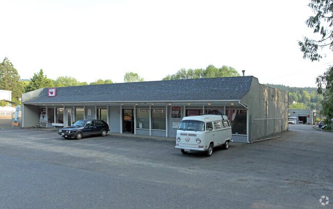
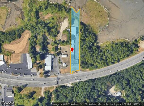
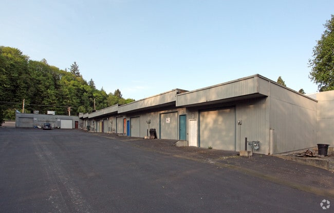
3062 W State Highway 16
332401-3-002-2000
THE EAST 100 FEET OF THE WEST 400 FEET OF GOVERNMENT LOT 3, LYING NORTHERLY OF STATE HIGHWAY 16, SECTION 33, TOWNSHIP 24 NORTH, RANGE 1 EAST, W.M., IN KITSAP COUNTY, WASHINGTON.
Commercialnec
Kitsap
AE
Washington
53035C0364F
3
2025
1.53 AC
2026
South Kitsap County
092102
Bremerton/Silverdale
17,072 SF
Bremerton-Silverdale, WA
DEMOGRAPHICS near 3062 W State Highway 16
1 Mile
3 Mile
5 Mile
2024 Total Population
1,970
27,434
82,954
2029 Population
1,994
28,239
84,272
Pop Growth 2024-2029
+ 1.22%
+ 2.93%
+ 1.59%
Average Age
35
39
39
2024 Total Households
678
10,585
31,068
HH Growth 2024-2029
+ 1.33%
+ 3.12%
+ 1.77%
Median Household Inc
$94,209
$72,007
$70,575
Avg Household Size
2.90
2.50
2.40
2024 Avg HH Vehicles
2.00
2.00
2.00
Median Home Value
$443,793
$405,203
$401,090
Median Year Built
2005
1993
1979
Nearby Places
Map Layers
Map Styles
 Street
 Aerial
- Restaurants
- Banks
- Shops
- Fitness
- Groceries
PUBLIC TRANSPORTATION
AIRPORT
Seattle-Tacoma International
DRIVE
WALK
Distance
Seattle-Tacoma International
69 min
49.7 mi
Freight Ports
Port of Seattle
DRIVE
WALK
Distance
Port of Seattle
79 min
59.9 mi
Nearby Properties
Address
Land Use
TOTAL SIZE
Lot Size
Zoning
Address
Land Use
TOTAL SIZE
Lot Size
Zoning
552 SF
17.39 AC
CITY
Address
Land Use
TOTAL SIZE
Lot Size
Zoning
21,408 SF
8.26 AC
BVSAP
Address
Land Use
TOTAL SIZE
Lot Size
Zoning
143,022 SF
11.24 AC
R4
Address
Land Use
TOTAL SIZE
Lot Size
Zoning
127,853 SF
7.41 AC
R4
Address
Land Use
TOTAL SIZE
Lot Size
Zoning
135,371 SF
6.04 AC
R4
Address
Land Use
TOTAL SIZE
Lot Size
Zoning
112,847 SF
6.80 AC
UM
Address
Land Use
TOTAL SIZE
Lot Size
Zoning
110,994 SF
5.35 AC
R4
Address
Land Use
TOTAL SIZE
Lot Size
Zoning
68,079 SF
2.16 AC
BVSAP
Address
Land Use
TOTAL SIZE
Lot Size
Zoning
73,931 SF
11.72 AC
FC
Address
Land Use
TOTAL SIZE
Lot Size
Zoning
43,944 SF
2.64 AC
FC
Address
Land Use
TOTAL SIZE
Lot Size
Zoning
55,866 SF
8.48 AC
FC
Address
Land Use
TOTAL SIZE
Lot Size
Zoning
138,087 SF
14.24 AC
CC
Address
Land Use
TOTAL SIZE
Lot Size
Zoning
68,708 SF
7.89 AC
PF
Address
Land Use
TOTAL SIZE
Lot Size
Zoning
520 SF
7.79 AC
C
Address
Land Use
TOTAL SIZE
Lot Size
Zoning
42,665 SF
5.55 AC
FC
Address
Land Use
TOTAL SIZE
Lot Size
Zoning
51,933 SF
4.07 AC
C
Address
Land Use
TOTAL SIZE
Lot Size
Zoning
43,318 SF
2.54 AC
R4
Address
Land Use
TOTAL SIZE
Lot Size
Zoning
85,187 SF
4.30 AC
CC
Address
Land Use
TOTAL SIZE
Lot Size
Zoning
75,000 SF
3.61 AC
LI
Address
Land Use
TOTAL SIZE
Lot Size
Zoning
52,601 SF
6.30 AC
BVSAP
Address
Land Use
TOTAL SIZE
Lot Size
Zoning
49,222 SF
3.39 AC
BPMU
Address
Land Use
TOTAL SIZE
Lot Size
Zoning
60,244 SF
8.83 AC
CC
Address
Land Use
TOTAL SIZE
Lot Size
Zoning
29,079 SF
9.95 AC
PF
Address
Land Use
TOTAL SIZE
Lot Size
Zoning
46,395 SF
2.41 AC
FC
Address
Land Use
TOTAL SIZE
Lot Size
Zoning
40,131 SF
4.90 AC
FC
Address
Land Use
TOTAL SIZE
Lot Size
Zoning
36,094 SF
2.84 AC
FC
Address
Land Use
TOTAL SIZE
Lot Size
Zoning
30,367 SF
4.55 AC
FC
Address
Land Use
TOTAL SIZE
Lot Size
Zoning
40,144 SF
5 AC
CITY
Address
Land Use
TOTAL SIZE
Lot Size
Zoning
31,961 SF
2.91 AC
R4
Address
Land Use
TOTAL SIZE
Lot Size
Zoning
38,580 SF
2.44 AC
I
The World's #1 Commercial Real Estate Marketplace
Connect with us
© 2025 CoStar Group
The information above has been obtained from sources believed reliable. While we do not doubt its accuracy we have not verified it and make no guarantee, warranty or representation about it. It is your responsibility to independently confirm its accuracy and completeness. Any projections, opinions, assumptions, or estimates used are for example only and do not represent the current or future performance of the property. The value of this transaction to you depends on tax and other factors which should be evaluated by your tax, financial, and legal advisors. You and your advisors should conduct a careful, independent investigation of the property to determine to your satisfaction the suitability of the property for your needs.