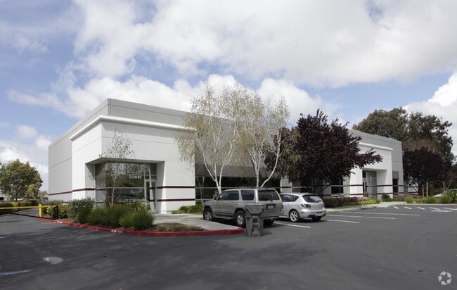
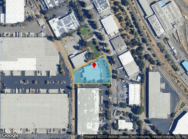
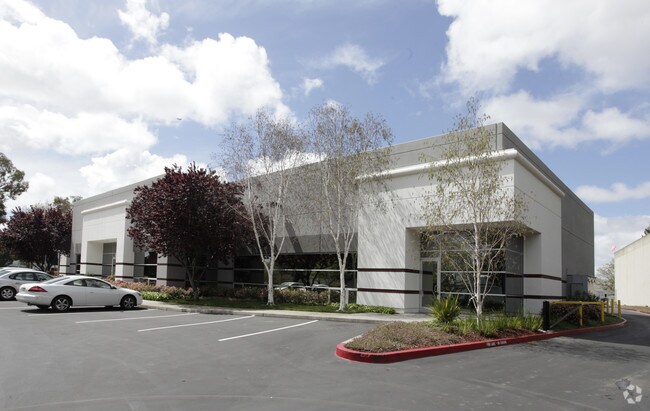
Property Record
30621 San Antonio St, Hayward, CA 94544
Current Lease Availabilities
NEARBY LISTINGS FOR SALE OR LEASE
Property Detail
30621 San Antonio St
475-0021-083-00
PARCEL MAP#6803
Warehouse
Alameda
X
California
06001C0431G
1.69 AC
2024
Hayward/Castro Valley
2025
East Bay/Oakland
438203
Oakland-Hayward-Berkeley, CA
25,788 SF
DEMOGRAPHICS near 30621 San Antonio St
1 Mile
3 Mile
5 Mile
2024 Total Population
13,810
156,392
321,932
2029 Population
13,508
151,308
311,357
Pop Growth 2024-2029
(2.19%)
(3.25%)
(3.28%)
Average Age
42
40
40
2024 Total Households
4,201
46,414
99,997
HH Growth 2024-2029
(2.33%)
(3.45%)
(3.47%)
Median Household Inc
$109,404
$115,254
$119,169
Avg Household Size
3.20
3.20
3.10
2024 Avg HH Vehicles
2.00
2.00
2.00
Median Home Value
$764,053
$832,082
$878,336
Median Year Built
1974
1975
1975
Nearby Places
- Restaurants
- Banks
- Shops
- Fitness
- Groceries
PUBLIC TRANSPORTATION
COMMUTER RAIL
DRIVE
WALK
Distance
14 min
6.1 mi
DRIVE
WALK
Distance
12 min
6.3 mi
AIRPORT
Metro Oakland International
DRIVE
WALK
Distance
Metro Oakland International
22 min
14.5 mi
Norman Y Mineta San Jose International
DRIVE
WALK
Distance
Norman Y Mineta San Jose International
34 min
24.6 mi
San Francisco International
DRIVE
WALK
Distance
San Francisco International
34 min
25.1 mi
Freight Ports
Port of Redwood City
DRIVE
WALK
Distance
Port of Redwood City
30 min
18.9 mi
Nearby Properties
Address
Land Use
TOTAL SIZE
Lot Size
Zoning
Address
Land Use
TOTAL SIZE
Lot Size
Zoning
29,436 SF
10.20 AC
Address
Land Use
TOTAL SIZE
Lot Size
Zoning
176,707 SF
2.47 AC
Address
Land Use
TOTAL SIZE
Lot Size
Zoning
312,244 SF
31.84 AC
Address
Land Use
TOTAL SIZE
Lot Size
Zoning
52,720 SF
4.21 AC
Address
Land Use
TOTAL SIZE
Lot Size
Zoning
203,984 SF
6.47 AC
Address
Land Use
TOTAL SIZE
Lot Size
Zoning
173,948 SF
6.10 AC
Address
Land Use
TOTAL SIZE
Lot Size
Zoning
175,325 SF
2.91 AC
Address
Land Use
TOTAL SIZE
Lot Size
Zoning
258,470 SF
11.64 AC
Address
Land Use
TOTAL SIZE
Lot Size
Zoning
58,991 SF
9.56 AC
Address
Land Use
TOTAL SIZE
Lot Size
Zoning
315,077 SF
3.35 AC
Address
Land Use
TOTAL SIZE
Lot Size
Zoning
234,858 SF
8.72 AC
I
Address
Land Use
TOTAL SIZE
Lot Size
Zoning
89,145 SF
5.12 AC
Address
Land Use
TOTAL SIZE
Lot Size
Zoning
146,599 SF
13.72 AC
Address
Land Use
TOTAL SIZE
Lot Size
Zoning
116,485 SF
1.81 AC
Address
Land Use
TOTAL SIZE
Lot Size
Zoning
Address
Land Use
TOTAL SIZE
Lot Size
Zoning
97,562 SF
4.56 AC
Address
Land Use
TOTAL SIZE
Lot Size
Zoning
154,113 SF
14.10 AC
Address
Land Use
TOTAL SIZE
Lot Size
Zoning
124,292 SF
9.69 AC
Address
Land Use
TOTAL SIZE
Lot Size
Zoning
89,344 SF
4.36 AC
Address
Land Use
TOTAL SIZE
Lot Size
Zoning
214,200 SF
9.04 AC
Address
Land Use
TOTAL SIZE
Lot Size
Zoning
200,384 SF
10.26 AC
Address
Land Use
TOTAL SIZE
Lot Size
Zoning
266,149 SF
13.45 AC
I
Address
Land Use
TOTAL SIZE
Lot Size
Zoning
92,922 SF
5 AC
Address
Land Use
TOTAL SIZE
Lot Size
Zoning
189,244 SF
16.56 AC
Address
Land Use
TOTAL SIZE
Lot Size
Zoning
100,128 SF
0.98 AC
Address
Land Use
TOTAL SIZE
Lot Size
Zoning
79,075 SF
4.32 AC
Address
Land Use
TOTAL SIZE
Lot Size
Zoning
203,857 SF
2.62 AC
Address
Land Use
TOTAL SIZE
Lot Size
Zoning
128,700 SF
11.21 AC
Address
Land Use
TOTAL SIZE
Lot Size
Zoning
64,127 SF
5.34 AC
Address
Land Use
TOTAL SIZE
Lot Size
Zoning
131,486 SF
55.82 AC
The World's #1 Commercial Real Estate Marketplace
Connect with us
© 2025 CoStar Group
The information above has been obtained from sources believed reliable. While we do not doubt its accuracy we have not verified it and make no guarantee, warranty or representation about it. It is your responsibility to independently confirm its accuracy and completeness. Any projections, opinions, assumptions, or estimates used are for example only and do not represent the current or future performance of the property. The value of this transaction to you depends on tax and other factors which should be evaluated by your tax, financial, and legal advisors. You and your advisors should conduct a careful, independent investigation of the property to determine to your satisfaction the suitability of the property for your needs.