Property Record
30659 Pearl Dr, Saint Joseph, MN 56374
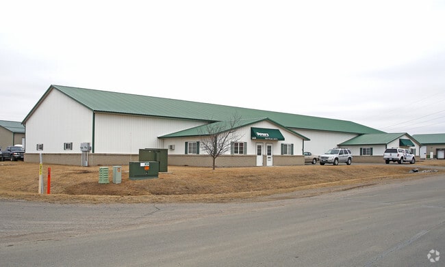

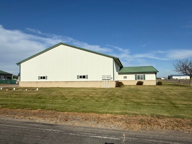
This Property Is For Sale
NEARBY LISTINGS FOR SALE OR LEASE
Property Detail
30659 Pearl Dr
St. Cloud, MN
St Joseph Industrial Park East
84-53300-0386
LOT 010 BLK 001 ST JOSEPH INDUSTRIAL PARK EAST SECTION 12 TOWNSHIP 124 RANGE 029 SECTION 12 TOWNSHIP 124 RANGE 029
Officebuilding
Stearns
X
Minnesota
27145C0610E
10
2025
1.31 AC
2025
Stearns County
011308
Minneapolis/St Paul
13,440 SF
DEMOGRAPHICS near 30659 Pearl Dr
1 Mile
3 Mile
5 Mile
2024 Total Population
626
23,029
64,192
2029 Population
651
23,836
66,439
Pop Growth 2024-2029
+ 3.99%
+ 3.50%
+ 3.50%
Average Age
38
37
37
2024 Total Households
244
8,951
25,446
HH Growth 2024-2029
+ 4.51%
+ 3.69%
+ 3.64%
Median Household Inc
$71,785
$66,897
$60,447
Avg Household Size
2.30
2.30
2.40
2024 Avg HH Vehicles
2.00
2.00
2.00
Median Home Value
$200,781
$223,574
$210,718
Median Year Built
1999
1997
1990
Nearby Places
Map Layers
Map Styles
 Street
 Aerial
- Restaurants
- Banks
- Shops
- Fitness
- Groceries
PUBLIC TRANSPORTATION
COMMUTER RAIL
DRIVE
WALK
Distance
18 min
8.6 mi
Nearby Properties
Address
Land Use
TOTAL SIZE
Lot Size
Zoning
Address
Land Use
TOTAL SIZE
Lot Size
Zoning
639,000 SF
216.67 AC
PUD28
Address
Land Use
TOTAL SIZE
Lot Size
Zoning
52,983 SF
22 AC
Address
Land Use
TOTAL SIZE
Lot Size
Zoning
148,150 SF
71.46 AC
Address
Land Use
TOTAL SIZE
Lot Size
Zoning
70,971 SF
11.40 AC
PUD57
Address
Land Use
TOTAL SIZE
Lot Size
Zoning
19.06 AC
Address
Land Use
TOTAL SIZE
Lot Size
Zoning
628,000 SF
40.51 AC
PUD16
Address
Land Use
TOTAL SIZE
Lot Size
Zoning
5.34 AC
Address
Land Use
TOTAL SIZE
Lot Size
Zoning
113,268 SF
12 AC
PUD32
Address
Land Use
TOTAL SIZE
Lot Size
Zoning
269,390 SF
15.77 AC
Address
Land Use
TOTAL SIZE
Lot Size
Zoning
146,285 SF
19.10 AC
Address
Land Use
TOTAL SIZE
Lot Size
Zoning
51.70 AC
PL20B2
Address
Land Use
TOTAL SIZE
Lot Size
Zoning
555,652 SF
26.04 AC
PUD16
Address
Land Use
TOTAL SIZE
Lot Size
Zoning
289,470 SF
23 AC
I3
Address
Land Use
TOTAL SIZE
Lot Size
Zoning
288,861 SF
30.27 AC
I3
Address
Land Use
TOTAL SIZE
Lot Size
Zoning
18,554 SF
8.41 AC
Address
Land Use
TOTAL SIZE
Lot Size
Zoning
3.89 AC
Address
Land Use
TOTAL SIZE
Lot Size
Zoning
9,448 SF
5.10 AC
Address
Land Use
TOTAL SIZE
Lot Size
Zoning
5.89 AC
Address
Land Use
TOTAL SIZE
Lot Size
Zoning
Address
Land Use
TOTAL SIZE
Lot Size
Zoning
320,450 SF
26.20 AC
I3
Address
Land Use
TOTAL SIZE
Lot Size
Zoning
4.91 AC
Address
Land Use
TOTAL SIZE
Lot Size
Zoning
20,450 SF
1 AC
Address
Land Use
TOTAL SIZE
Lot Size
Zoning
7.15 AC
Address
Land Use
TOTAL SIZE
Lot Size
Zoning
4.74 AC
Address
Land Use
TOTAL SIZE
Lot Size
Zoning
Address
Land Use
TOTAL SIZE
Lot Size
Zoning
3,088 SF
67.89 AC
PL20B1
Address
Land Use
TOTAL SIZE
Lot Size
Zoning
68,526 SF
9.80 AC
Address
Land Use
TOTAL SIZE
Lot Size
Zoning
33,973 SF
6.79 AC
Address
Land Use
TOTAL SIZE
Lot Size
Zoning
307,466 SF
21.87 AC
The World's #1 Commercial Real Estate Marketplace
Connect with us
© 2025 CoStar Group
The information above has been obtained from sources believed reliable. While we do not doubt its accuracy we have not verified it and make no guarantee, warranty or representation about it. It is your responsibility to independently confirm its accuracy and completeness. Any projections, opinions, assumptions, or estimates used are for example only and do not represent the current or future performance of the property. The value of this transaction to you depends on tax and other factors which should be evaluated by your tax, financial, and legal advisors. You and your advisors should conduct a careful, independent investigation of the property to determine to your satisfaction the suitability of the property for your needs.