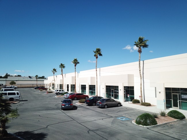
Property Record
3068 E Sunset Rd, Las Vegas, NV 89120
Property Detail
3068 E Sunset Rd
Las Vegas-Henderson-North Las Vegas, NV
S & P AIRPORT CENTER PLAT BOOK 81 PAGE 14 PT LOT 1 (AIR PARCEL S6-7 4260 SQ FT)
162-36-810-031
CLARK
Commercialnec
Nevada
B and X Area of moderate flood hazard, usually the area between the limits of the 100-year and 500-year floods.
1
2026
0.10 AC
2026
Airport/E Las Vegas
006900
Las Vegas
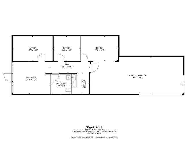
4,260 SF
NEARBY LISTINGS FOR SALE OR LEASE
DEMOGRAPHICS near 3068 E Sunset Rd
1 mile
3 mile
5 mile
2025 Total Population
4,165
140,275
419,378
2030 Population
4,287
146,571
438,404
Pop Growth 2025-2030
+ 2.93%
+ 4.49%
+ 4.54%
Average Age
46
41
41
2025 Total Households
1,790
57,118
172,596
HH Growth 2025-2030
+ 2.74%
+ 4.52%
+ 4.60%
Median Household Inc
$61,638
$72,468
$68,899
Avg Household Size
2.30
2.40
2.40
2025 Avg HH Vehicles
2.00
2.00
2.00
Median Home Value
$587,890
$433,946
$419,269
Median Year Built
1992
1988
1992
Nearby Places
Map Layers
Map Styles
 Street
 Aerial
Layers
 Traffic
 Biking
Places
Listings with unknown addresses are not visible on the map
- Restaurants
- Banks
- Shops
- Fitness
- Groceries
PUBLIC TRANSPORTATION
AIRPORT
Harry Reid International
Drive
Walk
Distance
Harry Reid International
9 min
3.9 mi
Boulder City Municipal
Drive
Walk
Distance
Boulder City Municipal
29 min
19.2 mi
SALE & LEASE HISTORY
LISTING DATE
SALE/LEASE

Nov 26, 2024
For Lease
Nov 24, 2021
For Sale
Mar 10, 2021
For Sale
Jul 25, 2025
For Sale
Jul 25, 2025
For Sale
Jul 25, 2025
For Sale
Jan 19, 2022
For Lease
Aug 23, 2023
For Sale
Aug 23, 2023
For Lease
Aug 06, 2020
For Sale
Nearby Properties
Address
Land Use
TOTAL SIZE
Lot Size
Zoning
Address
Land Use
TOTAL SIZE
Lot Size
Zoning
79.03 AC
PF
Address
Land Use
TOTAL SIZE
Lot Size
Zoning
76.93 AC
PF
Address
Land Use
TOTAL SIZE
Lot Size
Zoning
56.95 AC
PF
Address
Land Use
TOTAL SIZE
Lot Size
Zoning
459,983 SF
12.65 AC
M1
Address
Land Use
TOTAL SIZE
Lot Size
Zoning
21,257 SF
12.72 AC
Address
Land Use
TOTAL SIZE
Lot Size
Zoning
44.69 AC
PF
Address
Land Use
TOTAL SIZE
Lot Size
Zoning
50,000 SF
72.01 AC
PF
Address
Land Use
TOTAL SIZE
Lot Size
Zoning
399,206 SF
22.06 AC
MD
Address
Land Use
TOTAL SIZE
Lot Size
Zoning
95,928 SF
3.71 AC
C:U-V
Address
Land Use
TOTAL SIZE
Lot Size
Zoning
9,164 SF
22.81 AC
R3
Address
Land Use
TOTAL SIZE
Lot Size
Zoning
100.25 AC
RS1
Address
Land Use
TOTAL SIZE
Lot Size
Zoning
148.64 AC
PF
Address
Land Use
TOTAL SIZE
Lot Size
Zoning
8,891 SF
11.59 AC
Address
Land Use
TOTAL SIZE
Lot Size
Zoning
198.15 AC
PF
Address
Land Use
TOTAL SIZE
Lot Size
Zoning
18.75 AC
PF
Address
Land Use
TOTAL SIZE
Lot Size
Zoning
4,460 SF
27.52 AC
Address
Land Use
TOTAL SIZE
Lot Size
Zoning
160 AC
PF
Address
Land Use
TOTAL SIZE
Lot Size
Zoning
125,393 SF
12.33 AC
Address
Land Use
TOTAL SIZE
Lot Size
Zoning
152.76 AC
PF
Address
Land Use
TOTAL SIZE
Lot Size
Zoning
13,128 SF
47.47 AC
PF
Address
Land Use
TOTAL SIZE
Lot Size
Zoning
56,526 SF
12.44 AC
C2
Address
Land Use
TOTAL SIZE
Lot Size
Zoning
43.37 AC
RS1
Address
Land Use
TOTAL SIZE
Lot Size
Zoning
100.43 AC
PF
Address
Land Use
TOTAL SIZE
Lot Size
Zoning
266,782 SF
8.83 AC
Address
Land Use
TOTAL SIZE
Lot Size
Zoning
13,589 SF
56.80 AC
PF
Address
Land Use
TOTAL SIZE
Lot Size
Zoning
303,540 SF
4.99 AC
Address
Land Use
TOTAL SIZE
Lot Size
Zoning
213,048 SF
13.60 AC
Address
Land Use
TOTAL SIZE
Lot Size
Zoning
334,698 SF
18.44 AC
MD
Address
Land Use
TOTAL SIZE
Lot Size
Zoning
3,040 SF
16.76 AC
R4
Address
Land Use
TOTAL SIZE
Lot Size
Zoning
6,548 SF
15.75 AC
RH24
The World's #1 Commercial Real Estate Marketplace
Connect with us
© 2026 CoStar Group
The information above has been obtained from sources believed reliable. While we do not doubt its accuracy we have not verified it and make no guarantee, warranty or representation about it. It is your responsibility to independently confirm its accuracy and completeness. Any projections, opinions, assumptions, or estimates used are for example only and do not represent the current or future performance of the property. The value of this transaction to you depends on tax and other factors which should be evaluated by your tax, financial, and legal advisors. You and your advisors should conduct a careful, independent investigation of the property to determine to your satisfaction the suitability of the property for your needs.