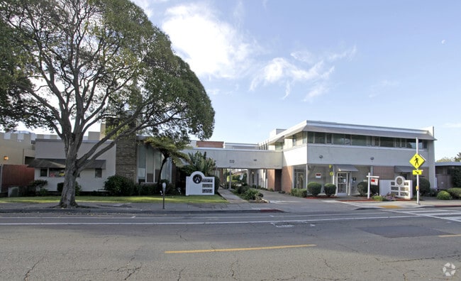
Property Record
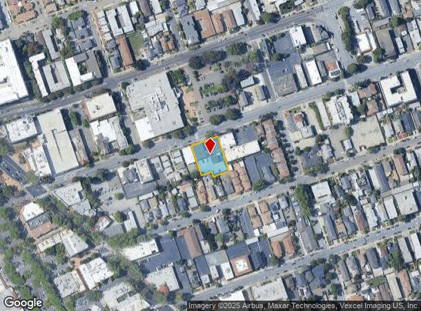
300-399 W Estudillo Ave, San Leandro, CA 94577


This Property Is For Sale
NEARBY LISTINGS FOR SALE OR LEASE
Property Detail
300-399 W Estudillo Ave
Oakland-Hayward-Berkeley, CA
Wicks Add
077-0551-041-01
LOT: 00001 BLK: 0041 AR: 0077 PAGE: 0551
Medicalbuilding
Alameda
X
California
06001C0257G
9,10
2024
0.45 AC
2025
San Leandro
432601
East Bay/Oakland
11,915 SF
DEMOGRAPHICS near 300-399 W Estudillo Ave
1 Mile
3 Mile
5 Mile
2024 Total Population
31,710
168,033
348,433
2029 Population
30,629
162,118
336,107
Pop Growth 2024-2029
(3.41%)
(3.52%)
(3.54%)
Average Age
42
40
40
2024 Total Households
11,947
54,067
113,272
HH Growth 2024-2029
(3.57%)
(3.73%)
(3.74%)
Median Household Inc
$92,034
$77,667
$85,036
Avg Household Size
2.60
3.00
2.90
2024 Avg HH Vehicles
2.00
2.00
2.00
Median Home Value
$760,529
$697,929
$749,064
Median Year Built
1957
1957
1957
Nearby Places
Map Layers
Map Styles
 Street
 Aerial
- Restaurants
- Banks
- Shops
- Fitness
- Groceries
PUBLIC TRANSPORTATION
TRANSIT/SUBWAY
San Leandro Station (Dublin/Pleasanton - Millbrae - Bay Area Rapid Transit (BART), Fremont - Daly City - Bay Area Rapid Transit (BART), Fremont - Richmond - Bay Area Rapid Transit (BART))
DRIVE
WALK
Distance
San Leandro Station (Dublin/Pleasanton - Millbrae - Bay Area Rapid Transit (BART), Fremont - Daly City - Bay Area Rapid Transit (BART), Fremont - Richmond - Bay Area Rapid Transit (BART))
2 min
10 min
0.5 mi
COMMUTER RAIL
DRIVE
WALK
Distance
12 min
6.3 mi
DRIVE
WALK
Distance
12 min
6.3 mi
AIRPORT
Metro Oakland International
DRIVE
WALK
Distance
Metro Oakland International
10 min
5.0 mi
San Francisco International
DRIVE
WALK
Distance
San Francisco International
37 min
28.0 mi
Norman Y Mineta San Jose International
DRIVE
WALK
Distance
Norman Y Mineta San Jose International
42 min
32.5 mi
Freight Ports
Port of Oakland
DRIVE
WALK
Distance
Port of Oakland
14 min
9.6 mi
Nearby Properties
Address
Land Use
TOTAL SIZE
Lot Size
Zoning
Address
Land Use
TOTAL SIZE
Lot Size
Zoning
285,595 SF
53.21 AC
Address
Land Use
TOTAL SIZE
Lot Size
Zoning
298,256 SF
12.16 AC
Address
Land Use
TOTAL SIZE
Lot Size
Zoning
165,923 SF
14.99 AC
Address
Land Use
TOTAL SIZE
Lot Size
Zoning
597,179 SF
19.16 AC
Address
Land Use
TOTAL SIZE
Lot Size
Zoning
437,104 SF
0.73 AC
Address
Land Use
TOTAL SIZE
Lot Size
Zoning
726,931 SF
37.03 AC
Address
Land Use
TOTAL SIZE
Lot Size
Zoning
713,010 SF
19.96 AC
Address
Land Use
TOTAL SIZE
Lot Size
Zoning
1.64 AC
Address
Land Use
TOTAL SIZE
Lot Size
Zoning
289,747 SF
11.31 AC
Address
Land Use
TOTAL SIZE
Lot Size
Zoning
374,725 SF
18.63 AC
Address
Land Use
TOTAL SIZE
Lot Size
Zoning
203,925 SF
8.54 AC
Address
Land Use
TOTAL SIZE
Lot Size
Zoning
323,080 SF
12.50 AC
I2
Address
Land Use
TOTAL SIZE
Lot Size
Zoning
99,039 SF
1.04 AC
Address
Land Use
TOTAL SIZE
Lot Size
Zoning
235,760 SF
9.52 AC
Address
Land Use
TOTAL SIZE
Lot Size
Zoning
292,698 SF
12.92 AC
Address
Land Use
TOTAL SIZE
Lot Size
Zoning
693,679 SF
43.49 AC
Address
Land Use
TOTAL SIZE
Lot Size
Zoning
294,146 SF
14.22 AC
Address
Land Use
TOTAL SIZE
Lot Size
Zoning
133,974 SF
4.99 AC
Address
Land Use
TOTAL SIZE
Lot Size
Zoning
240,668 SF
14.11 AC
Address
Land Use
TOTAL SIZE
Lot Size
Zoning
241,382 SF
12.72 AC
Address
Land Use
TOTAL SIZE
Lot Size
Zoning
214,062 SF
16.20 AC
Address
Land Use
TOTAL SIZE
Lot Size
Zoning
458,489 SF
27.38 AC
Address
Land Use
TOTAL SIZE
Lot Size
Zoning
24.51 AC
Address
Land Use
TOTAL SIZE
Lot Size
Zoning
132,018 SF
1.11 AC
Address
Land Use
TOTAL SIZE
Lot Size
Zoning
625,101 SF
35.95 AC
Address
Land Use
TOTAL SIZE
Lot Size
Zoning
168,104 SF
13.73 AC
Address
Land Use
TOTAL SIZE
Lot Size
Zoning
231,756 SF
9.15 AC
Address
Land Use
TOTAL SIZE
Lot Size
Zoning
136,618 SF
6.34 AC
Address
Land Use
TOTAL SIZE
Lot Size
Zoning
155,000 SF
8.41 AC
Address
Land Use
TOTAL SIZE
Lot Size
Zoning
105,730 SF
5.32 AC
The World's #1 Commercial Real Estate Marketplace
Connect with us
© 2025 CoStar Group
The information above has been obtained from sources believed reliable. While we do not doubt its accuracy we have not verified it and make no guarantee, warranty or representation about it. It is your responsibility to independently confirm its accuracy and completeness. Any projections, opinions, assumptions, or estimates used are for example only and do not represent the current or future performance of the property. The value of this transaction to you depends on tax and other factors which should be evaluated by your tax, financial, and legal advisors. You and your advisors should conduct a careful, independent investigation of the property to determine to your satisfaction the suitability of the property for your needs.