Property Record
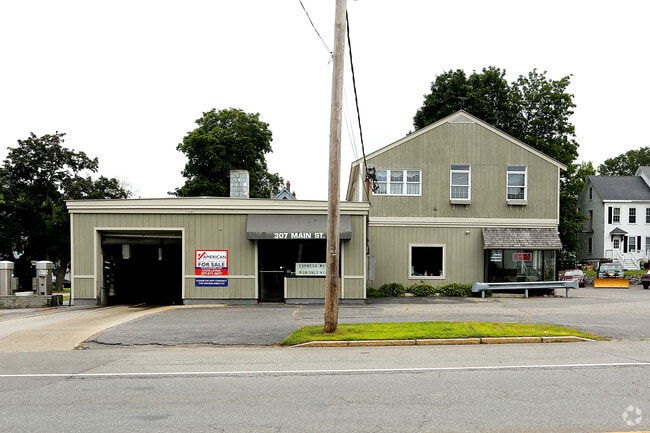
307 Main St, Westbrook, ME 04092

Property Detail
307 Main St
WSBR-000041-000000-000035
Cumberland
Commercialnec
Maine
11
35
B and X Area of moderate flood hazard, usually the area between the limits of the 100-year and 500-year floods.
0.40 AC
2023
SW Cumberland County
2023
Portland/South Portland
002800
Portland-South Portland, ME
4,902 SF
NEARBY LISTINGS FOR SALE OR LEASE
-
-
View all Westbrook listings for sale on LoopNet.com
DEMOGRAPHICS near 307 Main St
1 mile
3 mile
5 mile
2025 Total Population
5,164
41,063
104,996
2030 Population
5,218
41,399
106,173
Pop Growth 2025-2030
+ 1.05%
+ 0.82%
+ 1.12%
Average Age
41
42
41
2025 Total Households
2,303
17,733
47,720
HH Growth 2025-2030
+ 1.22%
+ 0.95%
+ 1.32%
Median Household Inc
$73,962
$96,283
$89,880
Avg Household Size
2.20
2.20
2.10
2025 Avg HH Vehicles
2.00
2.00
2.00
Median Home Value
$411,263
$426,279
$460,256
Median Year Built
1956
1963
1958
Nearby Places
Map Layers
Map Styles
 Street
 Aerial
Transit
 Traffic
 Biking
Places
Listings with unknown addresses are not visible on the map
- Restaurants
- Banks
- Shops
- Fitness
- Groceries
PUBLIC TRANSPORTATION
COMMUTER RAIL
Drive
Walk
Distance
9 min
4.0 mi
AIRPORT
Portland International Jetport
Drive
Walk
Distance
Portland International Jetport
12 min
5.3 mi
Freight Ports
Portland, ME
Drive
Walk
Distance
Portland, ME
12 min
5.8 mi
SALE & LEASE HISTORY
LISTING DATE
SALE/LEASE

Jul 25, 2019
For Sale
Aug 28, 2025
For Sale
Nearby Properties
Address
Land Use
TOTAL SIZE
Lot Size
Zoning
Address
Land Use
TOTAL SIZE
Lot Size
Zoning
86.50 AC
Address
Land Use
TOTAL SIZE
Lot Size
Zoning
84,636 SF
31.70 AC
22
Address
Land Use
TOTAL SIZE
Lot Size
Zoning
408.26 AC
Address
Land Use
TOTAL SIZE
Lot Size
Zoning
45.50 AC
Address
Land Use
TOTAL SIZE
Lot Size
Zoning
10.08 AC
Address
Land Use
TOTAL SIZE
Lot Size
Zoning
20.35 AC
Address
Land Use
TOTAL SIZE
Lot Size
Zoning
53.27 AC
22
Address
Land Use
TOTAL SIZE
Lot Size
Zoning
20.61 AC
TIFD
Address
Land Use
TOTAL SIZE
Lot Size
Zoning
13.20 AC
I
Address
Land Use
TOTAL SIZE
Lot Size
Zoning
176,100 SF
9.71 AC
Z
Address
Land Use
TOTAL SIZE
Lot Size
Zoning
135,968 SF
7.02 AC
Address
Land Use
TOTAL SIZE
Lot Size
Zoning
115,965 SF
6.27 AC
Z
Address
Land Use
TOTAL SIZE
Lot Size
Zoning
173,617 SF
15.28 AC
Address
Land Use
TOTAL SIZE
Lot Size
Zoning
125,719 SF
18.79 AC
Address
Land Use
TOTAL SIZE
Lot Size
Zoning
20.33 AC
Z
Address
Land Use
TOTAL SIZE
Lot Size
Zoning
139,588 SF
0.85 AC
16
Address
Land Use
TOTAL SIZE
Lot Size
Zoning
78,396 SF
8.60 AC
Address
Land Use
TOTAL SIZE
Lot Size
Zoning
17.95 AC
11
Address
Land Use
TOTAL SIZE
Lot Size
Zoning
19.08 AC
Address
Land Use
TOTAL SIZE
Lot Size
Zoning
152,378 SF
29.34 AC
21
Address
Land Use
TOTAL SIZE
Lot Size
Zoning
9.23 AC
Address
Land Use
TOTAL SIZE
Lot Size
Zoning
103,048 SF
2.78 AC
Address
Land Use
TOTAL SIZE
Lot Size
Zoning
144,304 SF
10.01 AC
Z
Address
Land Use
TOTAL SIZE
Lot Size
Zoning
33.07 AC
Address
Land Use
TOTAL SIZE
Lot Size
Zoning
88,032 SF
11.98 AC
Address
Land Use
TOTAL SIZE
Lot Size
Zoning
96,050 SF
12.90 AC
Z
Address
Land Use
TOTAL SIZE
Lot Size
Zoning
206,165 SF
25.75 AC
Address
Land Use
TOTAL SIZE
Lot Size
Zoning
11.94 AC
Address
Land Use
TOTAL SIZE
Lot Size
Zoning
95,457 SF
5.25 AC
Z
Address
Land Use
TOTAL SIZE
Lot Size
Zoning
19.86 AC
The World's #1 Commercial Real Estate Marketplace
Connect with us
© 2026 CoStar Group
The information above has been obtained from sources believed reliable. While we do not doubt its accuracy we have not verified it and make no guarantee, warranty or representation about it. It is your responsibility to independently confirm its accuracy and completeness. Any projections, opinions, assumptions, or estimates used are for example only and do not represent the current or future performance of the property. The value of this transaction to you depends on tax and other factors which should be evaluated by your tax, financial, and legal advisors. You and your advisors should conduct a careful, independent investigation of the property to determine to your satisfaction the suitability of the property for your needs.