Property Record
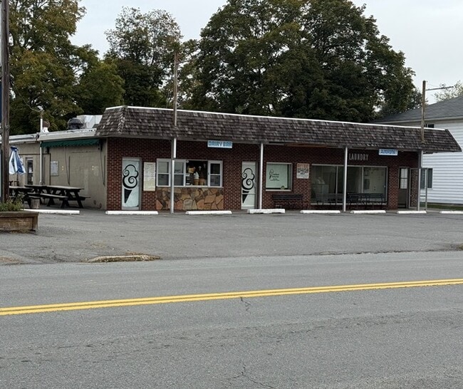
307 W Harford St, Milford, PA 18337


This Property Is For Sale
NEARBY LISTINGS FOR SALE OR LEASE
Property Detail
307 W Harford St
000403
LOTS 647 & 650 BUILDING-LAUNDRAMAT 4 OBS
Motel
Pike
X
Pennsylvania
34037C0008E
647,6
2024
0.44 AC
2025
Pike County
950603
Northern New Jersey
1,920 SF
Newark, NJ-PA
DEMOGRAPHICS near 307 W Harford St
1 Mile
3 Mile
5 Mile
2024 Total Population
1,745
4,571
10,309
2029 Population
1,779
4,611
10,367
Pop Growth 2024-2029
+ 1.95%
+ 0.88%
+ 0.56%
Average Age
47
46
45
2024 Total Households
812
1,968
4,228
HH Growth 2024-2029
+ 1.97%
+ 0.76%
+ 0.40%
Median Household Inc
$73,268
$77,133
$85,814
Avg Household Size
2.10
2.30
2.30
2024 Avg HH Vehicles
2.00
2.00
2.00
Median Home Value
$357,394
$334,389
$328,296
Median Year Built
1973
1978
1982
Nearby Places
Map Layers
Map Styles
 Street
 Aerial
- Restaurants
- Banks
- Shops
- Fitness
- Groceries
PUBLIC TRANSPORTATION
COMMUTER RAIL
Port Jervis (Bergen County/Port Jervis Line - NJ Transit Commuter Rail (NJ Transit), Main/Port Jervis Line - NJ Transit Commuter Rail (NJ Transit))
DRIVE
WALK
Distance
Port Jervis (Bergen County/Port Jervis Line - NJ Transit Commuter Rail (NJ Transit), Main/Port Jervis Line - NJ Transit Commuter Rail (NJ Transit))
19 min
7.6 mi
Freight Ports
Maher Terminal
DRIVE
WALK
Distance
Maher Terminal
101 min
67.5 mi
Nearby Properties
Address
Land Use
TOTAL SIZE
Lot Size
Zoning
Address
Land Use
TOTAL SIZE
Lot Size
Zoning
Address
Land Use
TOTAL SIZE
Lot Size
Zoning
9 AC
C2
Address
Land Use
TOTAL SIZE
Lot Size
Zoning
12.40 AC
R-1
Address
Land Use
TOTAL SIZE
Lot Size
Zoning
3,884 SF
518.94 AC
CD
Address
Land Use
TOTAL SIZE
Lot Size
Zoning
17.20 AC
R-1
Address
Land Use
TOTAL SIZE
Lot Size
Zoning
513.27 AC
CD
Address
Land Use
TOTAL SIZE
Lot Size
Zoning
205.69 AC
CD
Address
Land Use
TOTAL SIZE
Lot Size
Zoning
5.07 AC
C-2
Address
Land Use
TOTAL SIZE
Lot Size
Zoning
6.47 AC
R-4
Address
Land Use
TOTAL SIZE
Lot Size
Zoning
5 AC
MC
Address
Land Use
TOTAL SIZE
Lot Size
Zoning
1.90 AC
206C
Address
Land Use
TOTAL SIZE
Lot Size
Zoning
11.87 AC
C-2
Address
Land Use
TOTAL SIZE
Lot Size
Zoning
189,132 SF
27.19 AC
Address
Land Use
TOTAL SIZE
Lot Size
Zoning
3.91 AC
C-2
Address
Land Use
TOTAL SIZE
Lot Size
Zoning
1,188 SF
8.12 AC
C-2
Address
Land Use
TOTAL SIZE
Lot Size
Zoning
6.50 AC
R-1
Address
Land Use
TOTAL SIZE
Lot Size
Zoning
37,089 SF
0.95 AC
Address
Land Use
TOTAL SIZE
Lot Size
Zoning
191.08 AC
CD
Address
Land Use
TOTAL SIZE
Lot Size
Zoning
1,864 SF
27.30 AC
R-1
Address
Land Use
TOTAL SIZE
Lot Size
Zoning
2.43 AC
C-2
Address
Land Use
TOTAL SIZE
Lot Size
Zoning
151.49 AC
CD
Address
Land Use
TOTAL SIZE
Lot Size
Zoning
1.03 AC
C-2
Address
Land Use
TOTAL SIZE
Lot Size
Zoning
Address
Land Use
TOTAL SIZE
Lot Size
Zoning
5.39 AC
C-2
Address
Land Use
TOTAL SIZE
Lot Size
Zoning
162.10 AC
CD
Address
Land Use
TOTAL SIZE
Lot Size
Zoning
5,040 SF
0.46 AC
C-2
Address
Land Use
TOTAL SIZE
Lot Size
Zoning
40.47 AC
C-2
Address
Land Use
TOTAL SIZE
Lot Size
Zoning
2.01 AC
C2
Address
Land Use
TOTAL SIZE
Lot Size
Zoning
58,533 SF
0.68 AC
Address
Land Use
TOTAL SIZE
Lot Size
Zoning
115.78 AC
CD
The World's #1 Commercial Real Estate Marketplace
Connect with us
© 2026 CoStar Group
The information above has been obtained from sources believed reliable. While we do not doubt its accuracy we have not verified it and make no guarantee, warranty or representation about it. It is your responsibility to independently confirm its accuracy and completeness. Any projections, opinions, assumptions, or estimates used are for example only and do not represent the current or future performance of the property. The value of this transaction to you depends on tax and other factors which should be evaluated by your tax, financial, and legal advisors. You and your advisors should conduct a careful, independent investigation of the property to determine to your satisfaction the suitability of the property for your needs.