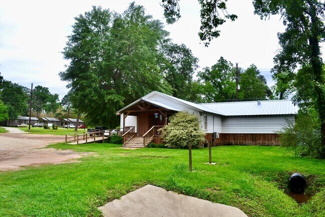
Property Record
307 W Main St, Kennard, TX 75847


NEARBY LISTINGS FOR SALE OR LEASE
-
-
View all Kennard listings for sale on LoopNet.com
Property Detail
307 W Main St
0035156
Kennard
Commercialnec
KENNARD LOT 19 & 20 BLK 5
X
Houston
48225C0450D
Texas
2025
19,20
2025
0.23 AC
950600
Texas East Area
2,944 SF
Other Market Areas
DEMOGRAPHICS near 307 W Main St
1 Mile
3 Mile
5 Mile
2024 Total Population
254
456
804
2029 Population
250
445
783
Pop Growth 2024-2029
(1.57%)
(2.41%)
(2.61%)
Average Age
45
45
46
2024 Total Households
107
194
344
HH Growth 2024-2029
(1.87%)
(2.58%)
(2.62%)
Median Household Inc
$52,857
$39,341
$37,903
Avg Household Size
2.40
2.40
2.30
2024 Avg HH Vehicles
2.00
2.00
2.00
Median Home Value
$87,754
$87,362
$88,749
Median Year Built
1967
1971
1974
Nearby Places
Map Layers
Map Styles
 Street
 Aerial
- Restaurants
- Banks
- Shops
- Fitness
- Groceries
SALE & LEASE HISTORY
LISTING DATE
SALE/LEASE

May 14, 2021
For Sale
Nearby Properties
Address
Land Use
TOTAL SIZE
Lot Size
Zoning
Address
Land Use
TOTAL SIZE
Lot Size
Zoning
61,326 SF
5.05 AC
Address
Land Use
TOTAL SIZE
Lot Size
Zoning
1 SF
2.37 AC
Address
Land Use
TOTAL SIZE
Lot Size
Zoning
400 AC
Address
Land Use
TOTAL SIZE
Lot Size
Zoning
25,640 SF
0.85 AC
Address
Land Use
TOTAL SIZE
Lot Size
Zoning
5,016 SF
1.36 AC
Address
Land Use
TOTAL SIZE
Lot Size
Zoning
23,584 SF
1.33 AC
Address
Land Use
TOTAL SIZE
Lot Size
Zoning
160 AC
Address
Land Use
TOTAL SIZE
Lot Size
Zoning
160 AC
Address
Land Use
TOTAL SIZE
Lot Size
Zoning
160 AC
Address
Land Use
TOTAL SIZE
Lot Size
Zoning
160 AC
Address
Land Use
TOTAL SIZE
Lot Size
Zoning
3,538 SF
2 AC
Address
Land Use
TOTAL SIZE
Lot Size
Zoning
5,336 SF
0.96 AC
Address
Land Use
TOTAL SIZE
Lot Size
Zoning
2,532 SF
2 AC
Address
Land Use
TOTAL SIZE
Lot Size
Zoning
10,516 SF
Address
Land Use
TOTAL SIZE
Lot Size
Zoning
7,055 SF
0.64 AC
Address
Land Use
TOTAL SIZE
Lot Size
Zoning
34.74 AC
Address
Land Use
TOTAL SIZE
Lot Size
Zoning
3,266 SF
16.85 AC
Address
Land Use
TOTAL SIZE
Lot Size
Zoning
2,580 SF
4 AC
Address
Land Use
TOTAL SIZE
Lot Size
Zoning
4,156 SF
Address
Land Use
TOTAL SIZE
Lot Size
Zoning
2,016 SF
53.93 AC
Address
Land Use
TOTAL SIZE
Lot Size
Zoning
2,128 SF
5 AC
Address
Land Use
TOTAL SIZE
Lot Size
Zoning
7,792 SF
0.45 AC
Address
Land Use
TOTAL SIZE
Lot Size
Zoning
160 AC
Address
Land Use
TOTAL SIZE
Lot Size
Zoning
1,636 SF
1 AC
Address
Land Use
TOTAL SIZE
Lot Size
Zoning
3,657 SF
4.89 AC
Address
Land Use
TOTAL SIZE
Lot Size
Zoning
4,108 SF
2.15 AC
Address
Land Use
TOTAL SIZE
Lot Size
Zoning
1,990 SF
3 AC
Address
Land Use
TOTAL SIZE
Lot Size
Zoning
10,420 SF
169.62 AC
Address
Land Use
TOTAL SIZE
Lot Size
Zoning
6,088 SF
94.02 AC
Address
Land Use
TOTAL SIZE
Lot Size
Zoning
3,148 SF
0.90 AC
The World's #1 Commercial Real Estate Marketplace
Connect with us
© 2026 CoStar Group
The information above has been obtained from sources believed reliable. While we do not doubt its accuracy we have not verified it and make no guarantee, warranty or representation about it. It is your responsibility to independently confirm its accuracy and completeness. Any projections, opinions, assumptions, or estimates used are for example only and do not represent the current or future performance of the property. The value of this transaction to you depends on tax and other factors which should be evaluated by your tax, financial, and legal advisors. You and your advisors should conduct a careful, independent investigation of the property to determine to your satisfaction the suitability of the property for your needs.