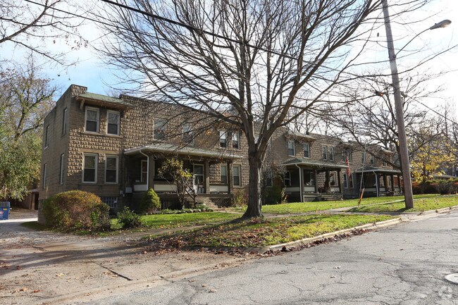
Property Record
307 Woodard Ave, Kent, OH 44240


NEARBY LISTINGS FOR SALE OR LEASE
-
-
View all Kent listings for sale on LoopNet.com
Property Detail
307 Woodard Ave
Akron, OH
Earl Ave
17-030-20-00-032-000
LOT 30 & EARL AVE LOT A
Apartment
Portage
X
Ohio
39133C0136E
30,a
2024
0.55 AC
2024
Kent
601300
Cleveland
6,916 SF
DEMOGRAPHICS near 307 Woodard Ave
1 Mile
3 Mile
5 Mile
2024 Total Population
8,842
42,770
92,943
2029 Population
8,978
43,201
93,316
Pop Growth 2024-2029
+ 1.54%
+ 1.01%
+ 0.40%
Average Age
38
36
39
2024 Total Households
3,981
17,331
38,011
HH Growth 2024-2029
+ 1.43%
+ 1.27%
+ 0.51%
Median Household Inc
$47,967
$52,008
$68,934
Avg Household Size
2.10
2.10
2.30
2024 Avg HH Vehicles
2.00
2.00
2.00
Median Home Value
$212,355
$223,093
$211,777
Median Year Built
1961
1974
1975
Nearby Places
Map Layers
Map Styles
 Street
 Aerial
- Restaurants
- Banks
- Shops
- Fitness
- Groceries
PUBLIC TRANSPORTATION
AIRPORT
Akron-Canton Regional
DRIVE
WALK
Distance
Akron-Canton Regional
29 min
25.2 mi
Freight Ports
Port of Baltimore
DRIVE
WALK
Distance
Port of Baltimore
1 min
283.5 mi
SALE & LEASE HISTORY
LISTING DATE
SALE/LEASE

Jul 03, 2018
For Sale
Nearby Properties
Address
Land Use
TOTAL SIZE
Lot Size
Zoning
Address
Land Use
TOTAL SIZE
Lot Size
Zoning
871,059 SF
404.65 AC
Address
Land Use
TOTAL SIZE
Lot Size
Zoning
342,850 SF
86.98 AC
Address
Land Use
TOTAL SIZE
Lot Size
Zoning
139,790 SF
102.12 AC
Address
Land Use
TOTAL SIZE
Lot Size
Zoning
183,977 SF
10.12 AC
Address
Land Use
TOTAL SIZE
Lot Size
Zoning
86,411 SF
0.23 AC
Address
Land Use
TOTAL SIZE
Lot Size
Zoning
77,663 SF
83.47 AC
Address
Land Use
TOTAL SIZE
Lot Size
Zoning
173,811 SF
9.34 AC
Address
Land Use
TOTAL SIZE
Lot Size
Zoning
61,748 SF
17.12 AC
Address
Land Use
TOTAL SIZE
Lot Size
Zoning
57,908 SF
6.36 AC
Address
Land Use
TOTAL SIZE
Lot Size
Zoning
141,562 SF
1.63 AC
Address
Land Use
TOTAL SIZE
Lot Size
Zoning
64,501 SF
175.97 AC
Address
Land Use
TOTAL SIZE
Lot Size
Zoning
150,616 SF
12.63 AC
Address
Land Use
TOTAL SIZE
Lot Size
Zoning
213,347 SF
30.75 AC
Address
Land Use
TOTAL SIZE
Lot Size
Zoning
146,435 SF
59.76 AC
Address
Land Use
TOTAL SIZE
Lot Size
Zoning
278,319 SF
34.50 AC
Address
Land Use
TOTAL SIZE
Lot Size
Zoning
179,055 SF
19.68 AC
Address
Land Use
TOTAL SIZE
Lot Size
Zoning
8.12 AC
Address
Land Use
TOTAL SIZE
Lot Size
Zoning
28,438 SF
9 AC
Address
Land Use
TOTAL SIZE
Lot Size
Zoning
310,705 SF
9.96 AC
Address
Land Use
TOTAL SIZE
Lot Size
Zoning
216,994 SF
10.94 AC
Address
Land Use
TOTAL SIZE
Lot Size
Zoning
52,575 SF
1.33 AC
Address
Land Use
TOTAL SIZE
Lot Size
Zoning
89,449 SF
14.59 AC
Address
Land Use
TOTAL SIZE
Lot Size
Zoning
34,394 SF
3.59 AC
Address
Land Use
TOTAL SIZE
Lot Size
Zoning
78,446 SF
18.02 AC
Address
Land Use
TOTAL SIZE
Lot Size
Zoning
176,320 SF
1.73 AC
Address
Land Use
TOTAL SIZE
Lot Size
Zoning
33,561 SF
2.62 AC
Address
Land Use
TOTAL SIZE
Lot Size
Zoning
67,107 SF
9.29 AC
Address
Land Use
TOTAL SIZE
Lot Size
Zoning
63,288 SF
0.88 AC
Address
Land Use
TOTAL SIZE
Lot Size
Zoning
73,306 SF
0.78 AC
Address
Land Use
TOTAL SIZE
Lot Size
Zoning
24,210 SF
2.34 AC
The World's #1 Commercial Real Estate Marketplace
Connect with us
© 2025 CoStar Group
The information above has been obtained from sources believed reliable. While we do not doubt its accuracy we have not verified it and make no guarantee, warranty or representation about it. It is your responsibility to independently confirm its accuracy and completeness. Any projections, opinions, assumptions, or estimates used are for example only and do not represent the current or future performance of the property. The value of this transaction to you depends on tax and other factors which should be evaluated by your tax, financial, and legal advisors. You and your advisors should conduct a careful, independent investigation of the property to determine to your satisfaction the suitability of the property for your needs.