Property Record
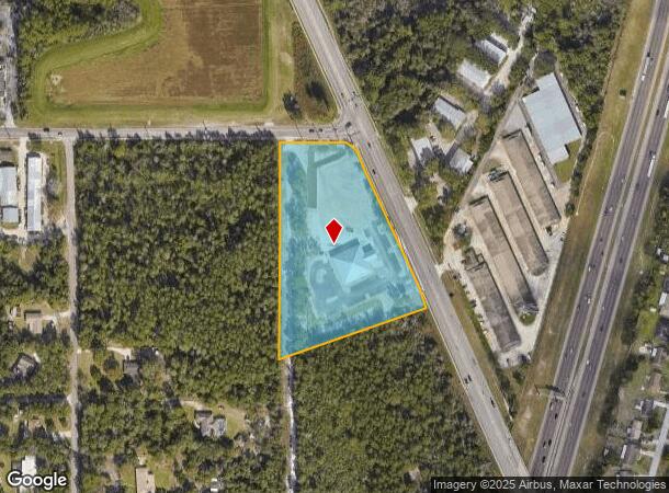
3070 Enterprise Rd, Debary, FL 32713
NEARBY LISTINGS FOR SALE OR LEASE
Property Detail
3070 Enterprise Rd
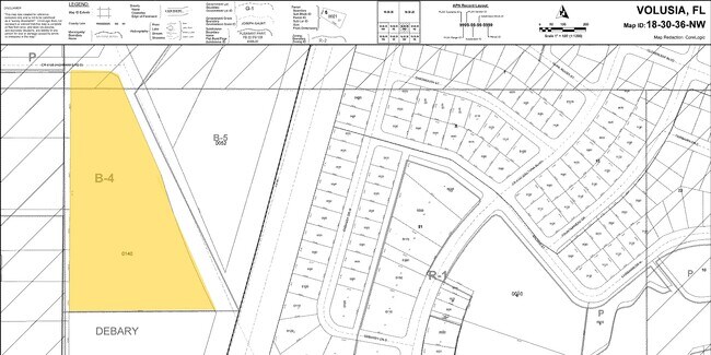
8036-00-00-0142
Enterprise
Religious
36-18-30 A PORTION OF THE NW 1/4 OF NW 1/4 & MEAS 207.03 FT ALONG THE S ROW/L OF HIGHBANKS RD & MEAS 577.7 FT ALONG THE W ROW/L OF ENTERPRISE RD & MEAS 496.42 FT ON S/L & 680.11 FT ON W/L PER OR 7826 PG 0250 PER OR 7825 PG 1099
X
Volusia
12127C0620K
Florida
2025
5.01 AC
2026
Deltona
090905
Deltona/Daytona Beach
10,646 SF
Deltona-Daytona Beach-Ormond Beach, FL
DEMOGRAPHICS near 3070 Enterprise Rd
1 Mile
3 Mile
5 Mile
2024 Total Population
5,911
53,608
99,777
2029 Population
6,468
58,884
109,701
Pop Growth 2024-2029
+ 9.42%
+ 9.84%
+ 9.95%
Average Age
41
42
42
2024 Total Households
2,219
20,709
38,227
HH Growth 2024-2029
+ 9.51%
+ 9.99%
+ 10.06%
Median Household Inc
$69,927
$62,233
$63,285
Avg Household Size
2.60
2.50
2.50
2024 Avg HH Vehicles
2.00
2.00
2.00
Median Home Value
$244,471
$228,334
$229,759
Median Year Built
1987
1987
1987
Nearby Places
Map Layers
Map Styles
 Street
 Aerial
- Restaurants
- Banks
- Shops
- Fitness
- Groceries
PUBLIC TRANSPORTATION
COMMUTER RAIL
Debary (SunRail - Florida Department of Transportation)
DRIVE
WALK
Distance
Debary (SunRail - Florida Department of Transportation)
8 min
4.3 mi
AIRPORT
Orlando Sanford International
DRIVE
WALK
Distance
Orlando Sanford International
28 min
15.4 mi
Daytona Beach International
DRIVE
WALK
Distance
Daytona Beach International
36 min
27.5 mi
Freight Ports
Port Canaveral
DRIVE
WALK
Distance
Port Canaveral
94 min
77.6 mi
Nearby Properties
Address
Land Use
TOTAL SIZE
Lot Size
Zoning
Address
Land Use
TOTAL SIZE
Lot Size
Zoning
485,392 SF
69.83 AC
ROW
Address
Land Use
TOTAL SIZE
Lot Size
Zoning
409,021 SF
38.53 AC
ROW
Address
Land Use
TOTAL SIZE
Lot Size
Zoning
369,949 SF
13.70 AC
Address
Land Use
TOTAL SIZE
Lot Size
Zoning
258,869 SF
38.34 AC
P
Address
Land Use
TOTAL SIZE
Lot Size
Zoning
232,605 SF
15.03 AC
12B4
Address
Land Use
TOTAL SIZE
Lot Size
Zoning
212,959 SF
65.31 AC
MPUDE
Address
Land Use
TOTAL SIZE
Lot Size
Zoning
9,460 SF
208.56 AC
Address
Land Use
TOTAL SIZE
Lot Size
Zoning
136,761 SF
17.77 AC
Address
Land Use
TOTAL SIZE
Lot Size
Zoning
121,380 SF
2.33 AC
Address
Land Use
TOTAL SIZE
Lot Size
Zoning
50,005 SF
5.60 AC
Address
Land Use
TOTAL SIZE
Lot Size
Zoning
170,850 SF
17.82 AC
Address
Land Use
TOTAL SIZE
Lot Size
Zoning
11,016 SF
13 AC
01MH1
Address
Land Use
TOTAL SIZE
Lot Size
Zoning
213,506 SF
21 AC
12R2
Address
Land Use
TOTAL SIZE
Lot Size
Zoning
193,964 SF
23.50 AC
Address
Land Use
TOTAL SIZE
Lot Size
Zoning
135,845 SF
18.34 AC
Address
Land Use
TOTAL SIZE
Lot Size
Zoning
123,193 SF
20 AC
01A3
Address
Land Use
TOTAL SIZE
Lot Size
Zoning
117,406 SF
17.58 AC
Address
Land Use
TOTAL SIZE
Lot Size
Zoning
169,634 SF
12.97 AC
01B
Address
Land Use
TOTAL SIZE
Lot Size
Zoning
11,509 SF
10 AC
01MH1
Address
Land Use
TOTAL SIZE
Lot Size
Zoning
139,919 SF
7.20 AC
MPUD
Address
Land Use
TOTAL SIZE
Lot Size
Zoning
147,759 SF
19.64 AC
Address
Land Use
TOTAL SIZE
Lot Size
Zoning
113,782 SF
18.52 AC
P
Address
Land Use
TOTAL SIZE
Lot Size
Zoning
214,666 SF
9 AC
Address
Land Use
TOTAL SIZE
Lot Size
Zoning
174,640 SF
13.46 AC
Address
Land Use
TOTAL SIZE
Lot Size
Zoning
64,836 SF
11.06 AC
BPUD
Address
Land Use
TOTAL SIZE
Lot Size
Zoning
44,975 SF
7.98 AC
Address
Land Use
TOTAL SIZE
Lot Size
Zoning
115,271 SF
17.08 AC
R4
Address
Land Use
TOTAL SIZE
Lot Size
Zoning
127,891 SF
10.58 AC
Address
Land Use
TOTAL SIZE
Lot Size
Zoning
87,981 SF
4.43 AC
Address
Land Use
TOTAL SIZE
Lot Size
Zoning
109,060 SF
13.21 AC
ROW
The World's #1 Commercial Real Estate Marketplace
Connect with us
© 2026 CoStar Group
The information above has been obtained from sources believed reliable. While we do not doubt its accuracy we have not verified it and make no guarantee, warranty or representation about it. It is your responsibility to independently confirm its accuracy and completeness. Any projections, opinions, assumptions, or estimates used are for example only and do not represent the current or future performance of the property. The value of this transaction to you depends on tax and other factors which should be evaluated by your tax, financial, and legal advisors. You and your advisors should conduct a careful, independent investigation of the property to determine to your satisfaction the suitability of the property for your needs.