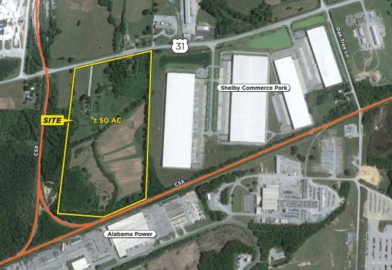
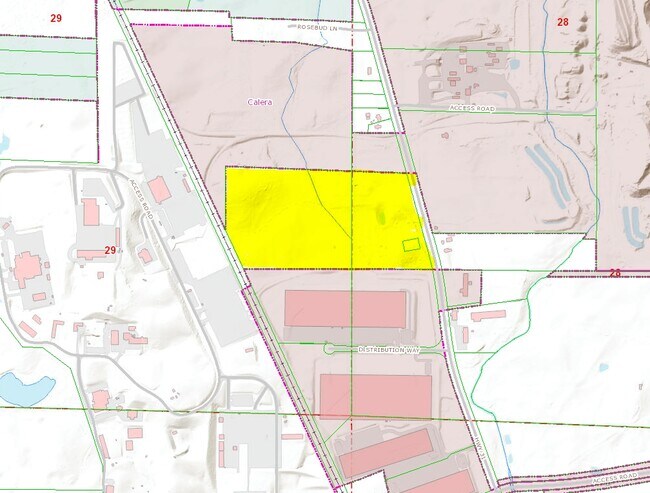
Property Record
3070 Highway 31, Calera, AL 35040
NEARBY LISTINGS FOR SALE OR LEASE
Property Detail
3070 Highway 31
22-8-28-0-000-013-000
BEG NW COR NE1/4 SE1/4 TH S TO N ROW L&N RR TH SE ON ROW 470TH E1150 TH N 1100 TH W TO POB
Commercialacreage
Shelby
AE
Alabama
01117C0392E
16.50 AC
2024
I-65 Corr/S Shelby County
2024
Birmingham
0306082006
Birmingham-Hoover, AL
DEMOGRAPHICS near 3070 Highway 31
1 Mile
3 Mile
5 Mile
2024 Total Population
103
12,017
27,845
2029 Population
113
13,071
30,354
Pop Growth 2024-2029
+ 9.71%
+ 8.77%
+ 9.01%
Average Age
38
37
38
2024 Total Households
37
4,555
10,378
HH Growth 2024-2029
+ 10.81%
+ 8.89%
+ 9.16%
Median Household Inc
$74,999
$78,235
$74,815
Avg Household Size
2.80
2.60
2.70
2024 Avg HH Vehicles
2.00
2.00
2.00
Median Home Value
$262,499
$209,005
$224,599
Median Year Built
1996
2004
2002
Nearby Places
Map Layers
Map Styles
 Street
 Aerial
- Restaurants
- Banks
- Shops
- Fitness
- Groceries
PUBLIC TRANSPORTATION
AIRPORT
Birmingham-Shuttlesworth International
DRIVE
WALK
Distance
Birmingham-Shuttlesworth International
42 min
32.3 mi
Freight Ports
Port of Mobile
DRIVE
WALK
Distance
Port of Mobile
250 min
229.2 mi
SALE & LEASE HISTORY
LISTING DATE
SALE/LEASE

Sep 24, 2016
For Sale
Nearby Properties
Address
Land Use
TOTAL SIZE
Lot Size
Zoning
Address
Land Use
TOTAL SIZE
Lot Size
Zoning
14,160 SF
6.75 AC
Address
Land Use
TOTAL SIZE
Lot Size
Zoning
139,905 SF
34.78 AC
Address
Land Use
TOTAL SIZE
Lot Size
Zoning
416,160 SF
58.85 AC
Address
Land Use
TOTAL SIZE
Lot Size
Zoning
573,600 SF
19.96 AC
Address
Land Use
TOTAL SIZE
Lot Size
Zoning
3,941 SF
5.60 AC
Address
Land Use
TOTAL SIZE
Lot Size
Zoning
500,500 SF
17.45 AC
Address
Land Use
TOTAL SIZE
Lot Size
Zoning
220,000 SF
21.76 AC
Address
Land Use
TOTAL SIZE
Lot Size
Zoning
368,066 SF
20.66 AC
Address
Land Use
TOTAL SIZE
Lot Size
Zoning
129,305 SF
50 AC
Address
Land Use
TOTAL SIZE
Lot Size
Zoning
270,600 SF
21.75 AC
Address
Land Use
TOTAL SIZE
Lot Size
Zoning
249,500 SF
16.15 AC
Address
Land Use
TOTAL SIZE
Lot Size
Zoning
6,234 SF
33 AC
Address
Land Use
TOTAL SIZE
Lot Size
Zoning
8,416 SF
16.12 AC
Address
Land Use
TOTAL SIZE
Lot Size
Zoning
208,000 SF
11.91 AC
Address
Land Use
TOTAL SIZE
Lot Size
Zoning
154,440 SF
12.03 AC
Address
Land Use
TOTAL SIZE
Lot Size
Zoning
46,031 SF
11.09 AC
Address
Land Use
TOTAL SIZE
Lot Size
Zoning
9,728 SF
11.01 AC
Address
Land Use
TOTAL SIZE
Lot Size
Zoning
116,219 SF
35.20 AC
Address
Land Use
TOTAL SIZE
Lot Size
Zoning
121,500 SF
13.80 AC
Address
Land Use
TOTAL SIZE
Lot Size
Zoning
50,558 SF
22.76 AC
Address
Land Use
TOTAL SIZE
Lot Size
Zoning
139,170 SF
15.30 AC
Address
Land Use
TOTAL SIZE
Lot Size
Zoning
104,643 SF
5.39 AC
Address
Land Use
TOTAL SIZE
Lot Size
Zoning
53,022 SF
2.20 AC
Address
Land Use
TOTAL SIZE
Lot Size
Zoning
8,328 SF
6.89 AC
Address
Land Use
TOTAL SIZE
Lot Size
Zoning
672 SF
7.33 AC
Address
Land Use
TOTAL SIZE
Lot Size
Zoning
241.36 AC
Address
Land Use
TOTAL SIZE
Lot Size
Zoning
6,275 SF
290 AC
Address
Land Use
TOTAL SIZE
Lot Size
Zoning
14,163 SF
12.78 AC
The World's #1 Commercial Real Estate Marketplace
Connect with us
© 2025 CoStar Group
The information above has been obtained from sources believed reliable. While we do not doubt its accuracy we have not verified it and make no guarantee, warranty or representation about it. It is your responsibility to independently confirm its accuracy and completeness. Any projections, opinions, assumptions, or estimates used are for example only and do not represent the current or future performance of the property. The value of this transaction to you depends on tax and other factors which should be evaluated by your tax, financial, and legal advisors. You and your advisors should conduct a careful, independent investigation of the property to determine to your satisfaction the suitability of the property for your needs.