Property Record
3070 Lumby Dr, Decatur, GA 30034
Current Lease Availabilities
NEARBY LISTINGS FOR SALE OR LEASE
Property Detail
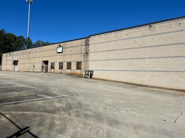
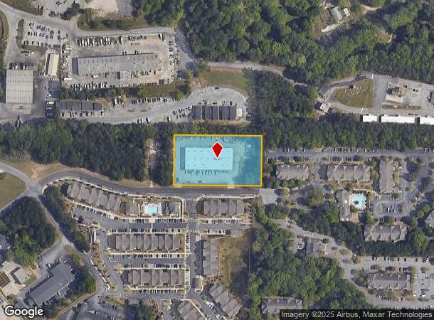
3070 Lumby Dr
15-104-07-005
400 X 225 X 400 X 225 2.07AC 12-13-88
Warehouse
DeKalb
X
Georgia
13089C0134J
0104
2025
2.07 AC
2025
Snapfinger
023410
Atlanta
21,917 SF
Atlanta-Sandy Springs-Roswell, GA
DEMOGRAPHICS near 3070 Lumby Dr
1 Mile
3 Mile
5 Mile
2024 Total Population
9,558
79,276
202,433
2029 Population
9,722
79,294
202,786
Pop Growth 2024-2029
+ 1.72%
+ 0.02%
+ 0.17%
Average Age
37
41
40
2024 Total Households
3,974
30,198
77,555
HH Growth 2024-2029
+ 1.94%
+ 0.09%
+ 0.25%
Median Household Inc
$35,757
$54,592
$63,193
Avg Household Size
2.30
2.60
2.50
2024 Avg HH Vehicles
1.00
2.00
2.00
Median Home Value
$208,958
$215,285
$246,153
Median Year Built
1977
1975
1978
Nearby Places
- Restaurants
- Banks
- Shops
- Fitness
- Groceries
PUBLIC TRANSPORTATION
AIRPORT
Hartsfield - Jackson Atlanta International
DRIVE
WALK
Distance
Hartsfield - Jackson Atlanta International
20 min
11.9 mi
Nearby Properties
Address
Land Use
TOTAL SIZE
Lot Size
Zoning
Address
Land Use
TOTAL SIZE
Lot Size
Zoning
76,654 SF
3.14 AC
C-1
Address
Land Use
TOTAL SIZE
Lot Size
Zoning
105,624 SF
11.62 AC
MR-2
Address
Land Use
TOTAL SIZE
Lot Size
Zoning
284,650 SF
21.75 AC
R100
Address
Land Use
TOTAL SIZE
Lot Size
Zoning
91,622 SF
18.99 AC
X
Address
Land Use
TOTAL SIZE
Lot Size
Zoning
522,850 SF
41.34 AC
RM75
Address
Land Use
TOTAL SIZE
Lot Size
Zoning
278,121 SF
20 AC
RM85
Address
Land Use
TOTAL SIZE
Lot Size
Zoning
72,870 SF
12.34 AC
C2
Address
Land Use
TOTAL SIZE
Lot Size
Zoning
245,053 SF
22.77 AC
RM85
Address
Land Use
TOTAL SIZE
Lot Size
Zoning
253,740 SF
13.33 AC
RM75
Address
Land Use
TOTAL SIZE
Lot Size
Zoning
13,114 SF
17.54 AC
RM100
Address
Land Use
TOTAL SIZE
Lot Size
Zoning
256,445 SF
11.71 AC
RM85
Address
Land Use
TOTAL SIZE
Lot Size
Zoning
40,809 SF
2.37 AC
C-1
Address
Land Use
TOTAL SIZE
Lot Size
Zoning
235,787 SF
15.43 AC
RM100
Address
Land Use
TOTAL SIZE
Lot Size
Zoning
59,246 SF
3.99 AC
X
Address
Land Use
TOTAL SIZE
Lot Size
Zoning
221,594 SF
15.90 AC
RM85
Address
Land Use
TOTAL SIZE
Lot Size
Zoning
554,853 SF
42.64 AC
RM75
Address
Land Use
TOTAL SIZE
Lot Size
Zoning
174,027 SF
35.37 AC
R100
Address
Land Use
TOTAL SIZE
Lot Size
Zoning
419,434 SF
21.59 AC
RM85
Address
Land Use
TOTAL SIZE
Lot Size
Zoning
132,604 SF
19.12 AC
RM100
Address
Land Use
TOTAL SIZE
Lot Size
Zoning
146,133 SF
16.10 AC
RM75
Address
Land Use
TOTAL SIZE
Lot Size
Zoning
367,452 SF
30.89 AC
RM100
Address
Land Use
TOTAL SIZE
Lot Size
Zoning
217,904 SF
14.84 AC
Address
Land Use
TOTAL SIZE
Lot Size
Zoning
172,503 SF
15.39 AC
RM75
Address
Land Use
TOTAL SIZE
Lot Size
Zoning
259,678 SF
14.20 AC
RM85
Address
Land Use
TOTAL SIZE
Lot Size
Zoning
118,310 SF
10.90 AC
RM85
Address
Land Use
TOTAL SIZE
Lot Size
Zoning
278,272 SF
21 AC
RM100
Address
Land Use
TOTAL SIZE
Lot Size
Zoning
320,450 SF
38.85 AC
M
Address
Land Use
TOTAL SIZE
Lot Size
Zoning
259,845 SF
17.12 AC
RM85
Address
Land Use
TOTAL SIZE
Lot Size
Zoning
134,156 SF
12.41 AC
RM100
Address
Land Use
TOTAL SIZE
Lot Size
Zoning
124,603 SF
10.60 AC
M
The World's #1 Commercial Real Estate Marketplace
Connect with us
© 2025 CoStar Group
The information above has been obtained from sources believed reliable. While we do not doubt its accuracy we have not verified it and make no guarantee, warranty or representation about it. It is your responsibility to independently confirm its accuracy and completeness. Any projections, opinions, assumptions, or estimates used are for example only and do not represent the current or future performance of the property. The value of this transaction to you depends on tax and other factors which should be evaluated by your tax, financial, and legal advisors. You and your advisors should conduct a careful, independent investigation of the property to determine to your satisfaction the suitability of the property for your needs.