Property Record
30741 3Rd Ave, Black Diamond, WA 98010
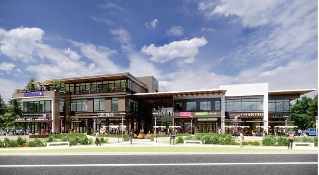

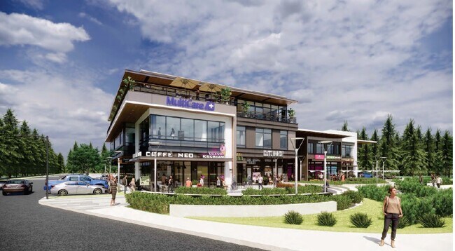
Property Detail
30741 3Rd Ave
112106-9069
POR OF NE 1/4 OF NW 1/4 LY W OF WLY MGN BLACK DIAMOND RD DAF BEG SW COR SD SUBD TH N ALG W LN THOF 341.53 FT TH E AT R/A 757.62 FT M/L TO SD MGN TH S 17-32-50 E ALG SD MGN 358.19 FT TO S LN SD SUBD TH W ALG SD S LN 865.61 FT TO TPOB
Storebuilding
King
CC
Washington
B and X Area of moderate flood hazard, usually the area between the limits of the 100-year and 500-year floods.
112106
2025
6.36 AC
2024
E King County
031605
Seattle/Puget Sound
28,421 SF
Seattle-Tacoma-Bellevue, WA
NEARBY LISTINGS FOR SALE OR LEASE
-
-
View all Black Diamond listings for lease on LoopNet.com
DEMOGRAPHICS near 30741 3Rd Ave
1 mile
3 mile
5 mile
2025 Total Population
1,184
26,782
61,944
2030 Population
1,237
28,191
64,624
Pop Growth 2025-2030
+ 4.48%
+ 5.26%
+ 4.33%
Average Age
38
38
39
2025 Total Households
402
8,812
21,027
HH Growth 2025-2030
+ 4.23%
+ 5.41%
+ 4.32%
Median Household Inc
$115,795
$143,563
$138,418
Avg Household Size
2.90
3.00
2.90
2025 Avg HH Vehicles
2.00
2.00
2.00
Median Home Value
$734,939
$763,686
$747,156
Median Year Built
1992
2000
1993
Nearby Places
Map Layers
Map Styles
 Street
 Aerial
Layers
 Traffic
 Biking
Places
Listings with unknown addresses are not visible on the map
- Restaurants
- Banks
- Shops
- Fitness
- Groceries
PUBLIC TRANSPORTATION
AIRPORT
Seattle-Tacoma International
Drive
Walk
Distance
Seattle-Tacoma International
42 min
23.7 mi
Freight Ports
Port of Tacoma
Drive
Walk
Distance
Port of Tacoma
43 min
27.2 mi
SALE & LEASE HISTORY
LISTING DATE
SALE/LEASE

Sep 25, 2016
For Lease
Nearby Properties
Address
Land Use
TOTAL SIZE
Lot Size
Zoning
Address
Land Use
TOTAL SIZE
Lot Size
Zoning
316,190 SF
35 AC
PUB
Address
Land Use
TOTAL SIZE
Lot Size
Zoning
188,400 SF
8.35 AC
TC
Address
Land Use
TOTAL SIZE
Lot Size
Zoning
163,680 SF
6.15 AC
MPD
Address
Land Use
TOTAL SIZE
Lot Size
Zoning
121,338 SF
5.13 AC
CB
Address
Land Use
TOTAL SIZE
Lot Size
Zoning
247,582 SF
39.90 AC
R1
Address
Land Use
TOTAL SIZE
Lot Size
Zoning
4,720 SF
122.76 AC
RLTC
Address
Land Use
TOTAL SIZE
Lot Size
Zoning
55,760 SF
8.56 AC
TC
Address
Land Use
TOTAL SIZE
Lot Size
Zoning
162,547 SF
14.18 AC
TC
Address
Land Use
TOTAL SIZE
Lot Size
Zoning
18,722 SF
9.57 AC
TC
Address
Land Use
TOTAL SIZE
Lot Size
Zoning
17,653 SF
5.16 AC
CC
Address
Land Use
TOTAL SIZE
Lot Size
Zoning
314.60 AC
CHECK WITH
Address
Land Use
TOTAL SIZE
Lot Size
Zoning
53,231 SF
1.96 AC
PUB
Address
Land Use
TOTAL SIZE
Lot Size
Zoning
63,969 SF
20.36 AC
PUB
Address
Land Use
TOTAL SIZE
Lot Size
Zoning
5,628 SF
3.93 AC
NB
Address
Land Use
TOTAL SIZE
Lot Size
Zoning
122.41 AC
PUB
Address
Land Use
TOTAL SIZE
Lot Size
Zoning
1,741 SF
4.55 AC
CB
Address
Land Use
TOTAL SIZE
Lot Size
Zoning
13,400 SF
3.18 AC
CB
Address
Land Use
TOTAL SIZE
Lot Size
Zoning
8,460 SF
3.05 AC
TC
Address
Land Use
TOTAL SIZE
Lot Size
Zoning
2,002 SF
31.31 AC
B/IP
Address
Land Use
TOTAL SIZE
Lot Size
Zoning
49,280 SF
13.86 AC
RA5
Address
Land Use
TOTAL SIZE
Lot Size
Zoning
18,692 SF
4.21 AC
CB
Address
Land Use
TOTAL SIZE
Lot Size
Zoning
24,700 SF
2.14 AC
TC
Address
Land Use
TOTAL SIZE
Lot Size
Zoning
9,675 SF
2.81 AC
CB
Address
Land Use
TOTAL SIZE
Lot Size
Zoning
6,795 SF
3.37 AC
TC
Address
Land Use
TOTAL SIZE
Lot Size
Zoning
3,066 SF
6.10 AC
R4
Address
Land Use
TOTAL SIZE
Lot Size
Zoning
5,494 SF
1.75 AC
TC
Address
Land Use
TOTAL SIZE
Lot Size
Zoning
19,722 SF
28.69 AC
RA5
Address
Land Use
TOTAL SIZE
Lot Size
Zoning
14,820 SF
1.56 AC
TC
The World's #1 Commercial Real Estate Marketplace
Connect with us
© 2026 CoStar Group
The information above has been obtained from sources believed reliable. While we do not doubt its accuracy we have not verified it and make no guarantee, warranty or representation about it. It is your responsibility to independently confirm its accuracy and completeness. Any projections, opinions, assumptions, or estimates used are for example only and do not represent the current or future performance of the property. The value of this transaction to you depends on tax and other factors which should be evaluated by your tax, financial, and legal advisors. You and your advisors should conduct a careful, independent investigation of the property to determine to your satisfaction the suitability of the property for your needs.