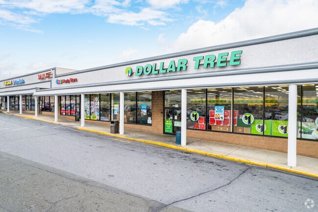
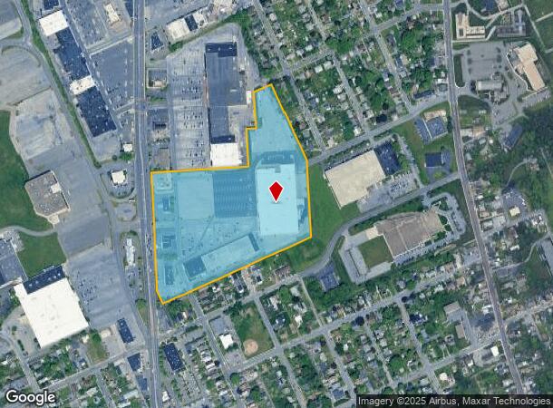
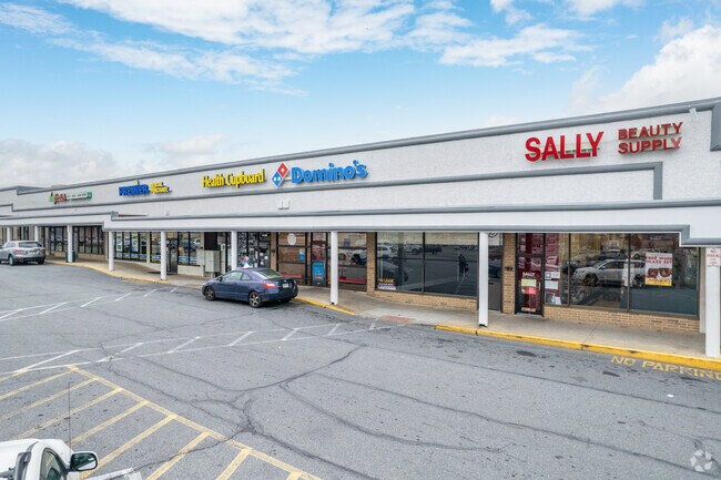
Property Record
3079 N 5Th St Hwy, Reading, PA 19605
NEARBY LISTINGS FOR SALE OR LEASE
Property Detail
3079 N 5Th St Hwy
Regionalshoppingcenterormallwithanchorstore
Berks
X
Pennsylvania
42011C0368G
19.15 AC
2025
Berks County
2025
Philadelphia
012600
Reading, PA
178,280 SF
66-5308-12-86-2670
DEMOGRAPHICS near 3079 N 5Th St Hwy
1 Mile
3 Mile
5 Mile
2024 Total Population
8,201
92,540
174,645
2029 Population
8,191
92,762
175,481
Pop Growth 2024-2029
(0.12%)
+ 0.24%
+ 0.48%
Average Age
39
37
38
2024 Total Households
3,016
32,349
63,446
HH Growth 2024-2029
(0.20%)
+ 0.28%
+ 0.51%
Median Household Inc
$64,420
$49,620
$54,341
Avg Household Size
2.60
2.70
2.60
2024 Avg HH Vehicles
2.00
2.00
2.00
Median Home Value
$157,096
$132,087
$160,543
Median Year Built
1953
1950
1954
Nearby Places
Map Layers
Map Styles
 Street
 Aerial
- Restaurants
- Banks
- Shops
- Fitness
- Groceries
PUBLIC TRANSPORTATION
AIRPORT
Lehigh Valley International
DRIVE
WALK
Distance
Lehigh Valley International
54 min
36.8 mi
Freight Ports
Port of Wilmington, RI
DRIVE
WALK
Distance
Port of Wilmington, RI
92 min
61.4 mi
SALE & LEASE HISTORY
LISTING DATE
SALE/LEASE

Sep 27, 2024
For Sale
Sep 25, 2016
For Lease
Sep 24, 2019
For Lease
Mar 01, 2019
For Lease
Dec 09, 2024
For Lease
Nearby Properties
Address
Land Use
TOTAL SIZE
Lot Size
Zoning
Address
Land Use
TOTAL SIZE
Lot Size
Zoning
609,600 SF
37.91 AC
Address
Land Use
TOTAL SIZE
Lot Size
Zoning
99,065 SF
81.29 AC
Address
Land Use
TOTAL SIZE
Lot Size
Zoning
141,767 SF
124.26 AC
Address
Land Use
TOTAL SIZE
Lot Size
Zoning
106,045 SF
19.16 AC
Address
Land Use
TOTAL SIZE
Lot Size
Zoning
250,600 SF
37.61 AC
Address
Land Use
TOTAL SIZE
Lot Size
Zoning
69,422 SF
40.02 AC
Address
Land Use
TOTAL SIZE
Lot Size
Zoning
386,194 SF
29.21 AC
Address
Land Use
TOTAL SIZE
Lot Size
Zoning
209,584 SF
24.33 AC
Address
Land Use
TOTAL SIZE
Lot Size
Zoning
203,665 SF
17.94 AC
Address
Land Use
TOTAL SIZE
Lot Size
Zoning
45,138 SF
20.34 AC
Address
Land Use
TOTAL SIZE
Lot Size
Zoning
241,410 SF
44.78 AC
Address
Land Use
TOTAL SIZE
Lot Size
Zoning
80,864 SF
10.38 AC
Address
Land Use
TOTAL SIZE
Lot Size
Zoning
104,559 SF
14.14 AC
Address
Land Use
TOTAL SIZE
Lot Size
Zoning
116,788 SF
13.11 AC
Address
Land Use
TOTAL SIZE
Lot Size
Zoning
402,006 SF
32.46 AC
Address
Land Use
TOTAL SIZE
Lot Size
Zoning
347,124 SF
19.93 AC
Address
Land Use
TOTAL SIZE
Lot Size
Zoning
158,736 SF
12.71 AC
Address
Land Use
TOTAL SIZE
Lot Size
Zoning
505,536 SF
31.80 AC
Address
Land Use
TOTAL SIZE
Lot Size
Zoning
66,369 SF
3 AC
Address
Land Use
TOTAL SIZE
Lot Size
Zoning
167,440 SF
13.03 AC
Address
Land Use
TOTAL SIZE
Lot Size
Zoning
42,496 SF
10.43 AC
Address
Land Use
TOTAL SIZE
Lot Size
Zoning
105,272 SF
2.19 AC
Address
Land Use
TOTAL SIZE
Lot Size
Zoning
170,000 SF
17.73 AC
Address
Land Use
TOTAL SIZE
Lot Size
Zoning
129,050 SF
Address
Land Use
TOTAL SIZE
Lot Size
Zoning
177,756 SF
13.04 AC
Address
Land Use
TOTAL SIZE
Lot Size
Zoning
116,236 SF
9.39 AC
Address
Land Use
TOTAL SIZE
Lot Size
Zoning
164,648 SF
14.13 AC
Address
Land Use
TOTAL SIZE
Lot Size
Zoning
247,500 SF
16.49 AC
Address
Land Use
TOTAL SIZE
Lot Size
Zoning
128,855 SF
43.50 AC
The World's #1 Commercial Real Estate Marketplace
Connect with us
© 2026 CoStar Group
The information above has been obtained from sources believed reliable. While we do not doubt its accuracy we have not verified it and make no guarantee, warranty or representation about it. It is your responsibility to independently confirm its accuracy and completeness. Any projections, opinions, assumptions, or estimates used are for example only and do not represent the current or future performance of the property. The value of this transaction to you depends on tax and other factors which should be evaluated by your tax, financial, and legal advisors. You and your advisors should conduct a careful, independent investigation of the property to determine to your satisfaction the suitability of the property for your needs.