Property Record
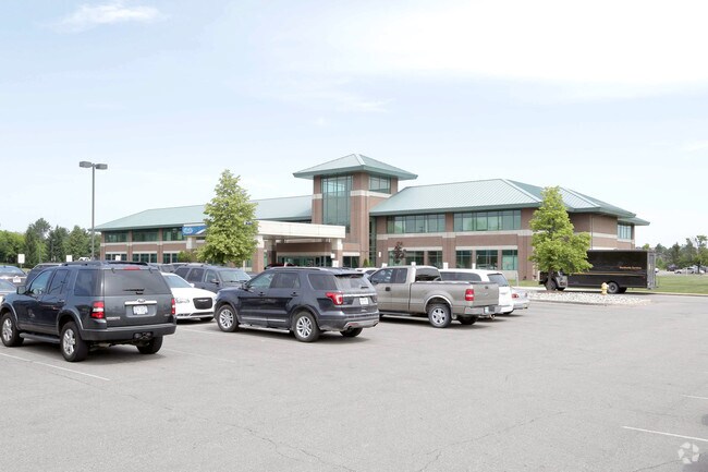
30795 23 Mile Rd, Chesterfield, MI 48047


NEARBY LISTINGS FOR SALE OR LEASE
Property Detail
30795 23 Mile Rd
15-09-16-451-007
Square Industrial Sub
Hospitalpublic
AMENDED PLAT OF LOTS 3,11,12 & THE VACATED PORTION OF TETON PLACE, TWENTY THREE SQUARE INDUSTRIAL SUB NO.1., L-127 P-43 & 44;
X
Macomb
26099C0266J
Michigan
2025
21.41 AC
2025
Macomb East
222106
Detroit
70,070 SF
Detroit-Warren-Dearborn, MI
DEMOGRAPHICS near 30795 23 Mile Rd
1 Mile
3 Mile
5 Mile
2024 Total Population
12,543
47,933
84,802
2029 Population
12,585
47,746
84,548
Pop Growth 2024-2029
+ 0.33%
(0.39%)
(0.30%)
Average Age
38
41
40
2024 Total Households
5,310
19,062
31,817
HH Growth 2024-2029
+ 0.47%
(0.36%)
(0.26%)
Median Household Inc
$59,522
$81,670
$85,467
Avg Household Size
2.30
2.40
2.60
2024 Avg HH Vehicles
2.00
2.00
2.00
Median Home Value
$208,047
$258,241
$264,107
Median Year Built
1992
1993
1995
Nearby Places
Map Layers
Map Styles
 Street
 Aerial
- Restaurants
- Banks
- Shops
- Fitness
- Groceries
PUBLIC TRANSPORTATION
AIRPORT
Windsor International
DRIVE
WALK
Distance
Windsor International
63 min
41.3 mi
Freight Ports
Port of Toledo
DRIVE
WALK
Distance
Port of Toledo
113 min
91.6 mi
Nearby Properties
Address
Land Use
TOTAL SIZE
Lot Size
Zoning
Address
Land Use
TOTAL SIZE
Lot Size
Zoning
808,240 SF
60.31 AC
RM 3 MU
Address
Land Use
TOTAL SIZE
Lot Size
Zoning
459,100 SF
Address
Land Use
TOTAL SIZE
Lot Size
Zoning
147,578 SF
12.84 AC
GC
Address
Land Use
TOTAL SIZE
Lot Size
Zoning
181,094 SF
14.89 AC
C3 GEN
Address
Land Use
TOTAL SIZE
Lot Size
Zoning
316,907 SF
21.18 AC
M2 GEN
Address
Land Use
TOTAL SIZE
Lot Size
Zoning
124,902 SF
11.38 AC
RM2 MU
Address
Land Use
TOTAL SIZE
Lot Size
Zoning
143,731 SF
16.25 AC
C2 SHO
Address
Land Use
TOTAL SIZE
Lot Size
Zoning
167,281 SF
16.12 AC
C3 GEN
Address
Land Use
TOTAL SIZE
Lot Size
Zoning
124,956 SF
15.78 AC
C2 SHO
Address
Land Use
TOTAL SIZE
Lot Size
Zoning
88,183 SF
27.97 AC
RM1 MU
Address
Land Use
TOTAL SIZE
Lot Size
Zoning
112,151 SF
9.31 AC
C3 GEN
Address
Land Use
TOTAL SIZE
Lot Size
Zoning
169,535 SF
12.20 AC
I
Address
Land Use
TOTAL SIZE
Lot Size
Zoning
88,452 SF
8.36 AC
C3 GEN
Address
Land Use
TOTAL SIZE
Lot Size
Zoning
204,318 SF
27.75 AC
C3 GEN
Address
Land Use
TOTAL SIZE
Lot Size
Zoning
179,250 SF
26.35 AC
M2 GEN
Address
Land Use
TOTAL SIZE
Lot Size
Zoning
679,606 SF
29.98 AC
M2 GEN
Address
Land Use
TOTAL SIZE
Lot Size
Zoning
5,541 SF
130.51 AC
MHP MO
Address
Land Use
TOTAL SIZE
Lot Size
Zoning
218,662 SF
16.61 AC
M2 GEN
Address
Land Use
TOTAL SIZE
Lot Size
Zoning
72,184 SF
69.68 AC
M2 GEN
Address
Land Use
TOTAL SIZE
Lot Size
Zoning
118,368 SF
14.46 AC
RM 3 MU
Address
Land Use
TOTAL SIZE
Lot Size
Zoning
184,401 SF
19.98 AC
RM 3 MU
Address
Land Use
TOTAL SIZE
Lot Size
Zoning
142,306 SF
10.22 AC
M1 LIG
Address
Land Use
TOTAL SIZE
Lot Size
Zoning
156,262 SF
16.23 AC
RM2 MU
Address
Land Use
TOTAL SIZE
Lot Size
Zoning
78,805 SF
4.94 AC
M2 GEN
Address
Land Use
TOTAL SIZE
Lot Size
Zoning
313,174 SF
22.23 AC
M2 GEN
Address
Land Use
TOTAL SIZE
Lot Size
Zoning
179,200 SF
10.12 AC
RT TECH
Address
Land Use
TOTAL SIZE
Lot Size
Zoning
128,187 SF
8.79 AC
M2 GEN
Address
Land Use
TOTAL SIZE
Lot Size
Zoning
137,092 SF
18.25 AC
C2 SHO
Address
Land Use
TOTAL SIZE
Lot Size
Zoning
124,280 SF
11.50 AC
RM-1
Address
Land Use
TOTAL SIZE
Lot Size
Zoning
161,123 SF
31.11 AC
M1 LIG
The World's #1 Commercial Real Estate Marketplace
Connect with us
© 2025 CoStar Group
The information above has been obtained from sources believed reliable. While we do not doubt its accuracy we have not verified it and make no guarantee, warranty or representation about it. It is your responsibility to independently confirm its accuracy and completeness. Any projections, opinions, assumptions, or estimates used are for example only and do not represent the current or future performance of the property. The value of this transaction to you depends on tax and other factors which should be evaluated by your tax, financial, and legal advisors. You and your advisors should conduct a careful, independent investigation of the property to determine to your satisfaction the suitability of the property for your needs.