Property Record
Lower Ahtanum Rd/S 3Rd Ave, Union Gap, WA 98903
NEARBY LISTINGS FOR SALE OR LEASE
Property Detail
Lower Ahtanum Rd/S 3Rd Ave
Yakima, WA
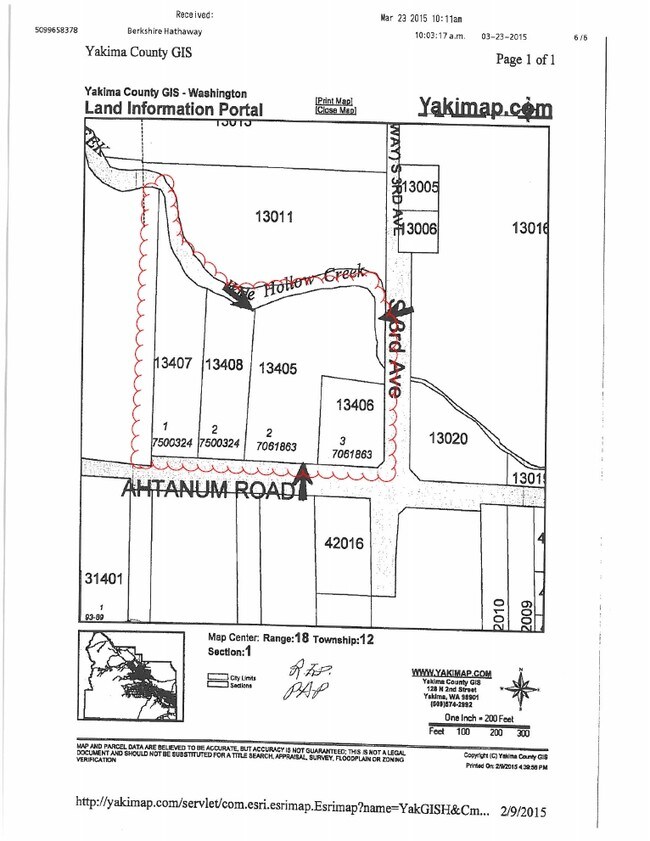
SP AF# 7061863: LOT 3, EX E 20 FT FOR RD R/W & SE COR SITE TRIANGLE
181201-13408
Yakima
Vacantlandnec
Washington
AE
3
53077C1042F
1.54 AC
2025
Union Gap
2025
Yakima
001300
DEMOGRAPHICS near Lower Ahtanum Rd/S 3Rd Ave
1 Mile
3 Mile
5 Mile
2024 Total Population
3,470
46,393
108,002
2029 Population
3,512
46,443
108,720
Pop Growth 2024-2029
+ 1.21%
+ 0.11%
+ 0.66%
Average Age
37
35
37
2024 Total Households
1,195
15,492
39,159
HH Growth 2024-2029
+ 1.26%
+ 0.02%
+ 0.68%
Median Household Inc
$41,170
$49,247
$52,611
Avg Household Size
2.80
2.90
2.60
2024 Avg HH Vehicles
2.00
2.00
2.00
Median Home Value
$147,507
$189,452
$241,409
Median Year Built
1972
1962
1971
Nearby Places
- Restaurants
- Banks
- Shops
- Fitness
- Groceries
PUBLIC TRANSPORTATION
AIRPORT
Yakima Air Trml/McAllister Field
DRIVE
WALK
Distance
Yakima Air Trml/McAllister Field
5 min
2.4 mi
Freight Ports
Port of Tacoma
DRIVE
WALK
Distance
Port of Tacoma
190 min
160.5 mi
Nearby Properties
Address
Land Use
TOTAL SIZE
Lot Size
Zoning
Address
Land Use
TOTAL SIZE
Lot Size
Zoning
390,527 SF
11.86 AC
R3
Address
Land Use
TOTAL SIZE
Lot Size
Zoning
409,453 SF
8.25 AC
R3
Address
Land Use
TOTAL SIZE
Lot Size
Zoning
326,323 SF
30.05 AC
R2
Address
Land Use
TOTAL SIZE
Lot Size
Zoning
347,665 SF
37.77 AC
B2
Address
Land Use
TOTAL SIZE
Lot Size
Zoning
499,230 SF
22.57 AC
M1
Address
Land Use
TOTAL SIZE
Lot Size
Zoning
193,955 SF
9.94 AC
C1
Address
Land Use
TOTAL SIZE
Lot Size
Zoning
208,322 SF
3.69 AC
PUB
Address
Land Use
TOTAL SIZE
Lot Size
Zoning
106,878 SF
3.46 AC
RD
Address
Land Use
TOTAL SIZE
Lot Size
Zoning
329,388 SF
16.13 AC
M1
Address
Land Use
TOTAL SIZE
Lot Size
Zoning
82,436 SF
11 AC
RD
Address
Land Use
TOTAL SIZE
Lot Size
Zoning
345,698 SF
3.52 AC
C1
Address
Land Use
TOTAL SIZE
Lot Size
Zoning
100,992 SF
9.15 AC
RD
Address
Land Use
TOTAL SIZE
Lot Size
Zoning
91,856 SF
9.17 AC
RD
Address
Land Use
TOTAL SIZE
Lot Size
Zoning
162,216 SF
11 AC
M1
Address
Land Use
TOTAL SIZE
Lot Size
Zoning
56,505 SF
2.75 AC
C1
Address
Land Use
TOTAL SIZE
Lot Size
Zoning
57,009 SF
212.58 AC
AS
Address
Land Use
TOTAL SIZE
Lot Size
Zoning
64,171 SF
48.08 AC
PUB
Address
Land Use
TOTAL SIZE
Lot Size
Zoning
158,890 SF
13.84 AC
B2
Address
Land Use
TOTAL SIZE
Lot Size
Zoning
128,789 SF
6.65 AC
R3
Address
Land Use
TOTAL SIZE
Lot Size
Zoning
135,634 SF
9.84 AC
C1
Address
Land Use
TOTAL SIZE
Lot Size
Zoning
97,976 SF
3.98 AC
SCC
Address
Land Use
TOTAL SIZE
Lot Size
Zoning
89,850 SF
14.03 AC
R1
Address
Land Use
TOTAL SIZE
Lot Size
Zoning
325,959 SF
11.95 AC
M2
Address
Land Use
TOTAL SIZE
Lot Size
Zoning
80,374 SF
8.99 AC
C1
Address
Land Use
TOTAL SIZE
Lot Size
Zoning
114,406 SF
15.50 AC
PUB
Address
Land Use
TOTAL SIZE
Lot Size
Zoning
151,831 SF
21.08 AC
M1
Address
Land Use
TOTAL SIZE
Lot Size
Zoning
173,916 SF
7.27 AC
M1
Address
Land Use
TOTAL SIZE
Lot Size
Zoning
43,687 SF
3.33 AC
C1
Address
Land Use
TOTAL SIZE
Lot Size
Zoning
131,100 SF
3.49 AC
M1
Address
Land Use
TOTAL SIZE
Lot Size
Zoning
195,753 SF
11.66 AC
M1
The World's #1 Commercial Real Estate Marketplace
Connect with us
© 2025 CoStar Group
The information above has been obtained from sources believed reliable. While we do not doubt its accuracy we have not verified it and make no guarantee, warranty or representation about it. It is your responsibility to independently confirm its accuracy and completeness. Any projections, opinions, assumptions, or estimates used are for example only and do not represent the current or future performance of the property. The value of this transaction to you depends on tax and other factors which should be evaluated by your tax, financial, and legal advisors. You and your advisors should conduct a careful, independent investigation of the property to determine to your satisfaction the suitability of the property for your needs.