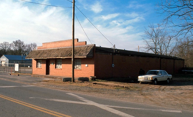
Property Record
308 E Craighead Rd, Charlotte, NC 28206

Property Detail
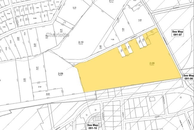
308 E Craighead Rd
091-112-08
L1 M67-510
Multifamilydwelling
MECKLENBURG
UR2CD
North Carolina
AE The base floodplain where base flood elevations are provided. AE Zones are now used on new format FIRMs instead of A1-A30 Zones.
1
2024
9.43 AC
2025
Sugar Creek
005200
Charlotte
285,032 SF
Charlotte-Concord-Gastonia, NC-SC
NEARBY LISTINGS FOR SALE OR LEASE
DEMOGRAPHICS near 308 E Craighead Rd
1 mile
3 mile
5 mile
2025 Total Population
13,662
113,514
300,030
2030 Population
15,151
124,208
327,720
Pop Growth 2025-2030
+ 10.90%
+ 9.42%
+ 9.23%
Average Age
35
36
36
2025 Total Households
6,482
50,333
131,497
HH Growth 2025-2030
+ 11.08%
+ 9.71%
+ 9.50%
Median Household Inc
$72,869
$67,442
$70,985
Avg Household Size
2.10
2.20
2.20
2025 Avg HH Vehicles
1.00
1.00
2.00
Median Home Value
$534,060
$412,730
$401,867
Median Year Built
1997
1987
1992
Nearby Places
Map Layers
Map Styles
 Street
 Aerial
Layers
 Traffic
 Biking
Places
Listings with unknown addresses are not visible on the map
- Restaurants
- Banks
- Shops
- Fitness
- Groceries
PUBLIC TRANSPORTATION
TRANSIT/SUBWAY
Sugar Creek Station (Light Rail - Lynx Blue Line - CATS)
Drive
Walk
Distance
Sugar Creek Station (Light Rail - Lynx Blue Line - CATS)
2 min
19 min
0.5 mi
36Th St Station (Light Rail - Lynx Blue Line - CATS)
Drive
Walk
Distance
36Th St Station (Light Rail - Lynx Blue Line - CATS)
3 min
20 min
1.1 mi
COMMUTER RAIL
Charlotte Amtrak Station (Carolinian - Amtrak, Crescent - Amtrak, Piedmont - Amtrak)
Drive
Walk
Distance
Charlotte Amtrak Station (Carolinian - Amtrak, Crescent - Amtrak, Piedmont - Amtrak)
5 min
2.2 mi
AIRPORT
Charlotte/Douglas International
Drive
Walk
Distance
Charlotte/Douglas International
22 min
11.1 mi
Concord-Padgett Regional
Drive
Walk
Distance
Concord-Padgett Regional
19 min
12.4 mi
Freight Ports
North Charleston Terminal
Drive
Walk
Distance
North Charleston Terminal
235 min
202.9 mi
Nearby Properties
Address
Land Use
TOTAL SIZE
Lot Size
Zoning
Address
Land Use
TOTAL SIZE
Lot Size
Zoning
780,000 SF
7.69 AC
UMUD-O
Address
Land Use
TOTAL SIZE
Lot Size
Zoning
1,097,257 SF
2.34 AC
UMUD-O
Address
Land Use
TOTAL SIZE
Lot Size
Zoning
955,273 SF
1.83 AC
Address
Land Use
TOTAL SIZE
Lot Size
Zoning
1,097,857 SF
2.40 AC
UMUDO
Address
Land Use
TOTAL SIZE
Lot Size
Zoning
1,052,203 SF
2.17 AC
Address
Land Use
TOTAL SIZE
Lot Size
Zoning
1,752,744 SF
3.20 AC
UMUDO
Address
Land Use
TOTAL SIZE
Lot Size
Zoning
852,355 SF
16.72 AC
MUDDO
Address
Land Use
TOTAL SIZE
Lot Size
Zoning
1,053,936 SF
2.47 AC
UMUD
Address
Land Use
TOTAL SIZE
Lot Size
Zoning
588,300 SF
1.45 AC
Address
Land Use
TOTAL SIZE
Lot Size
Zoning
663,752 SF
1.21 AC
UMUD
Address
Land Use
TOTAL SIZE
Lot Size
Zoning
733,107 SF
3.48 AC
UMUD
Address
Land Use
TOTAL SIZE
Lot Size
Zoning
729,709 SF
10.67 AC
B2
Address
Land Use
TOTAL SIZE
Lot Size
Zoning
71.86 AC
UR-3
Address
Land Use
TOTAL SIZE
Lot Size
Zoning
690,862 SF
136.80 AC
R17MF
Address
Land Use
TOTAL SIZE
Lot Size
Zoning
447,803 SF
0.27 AC
Address
Land Use
TOTAL SIZE
Lot Size
Zoning
311,425 SF
0.92 AC
UMUD
Address
Land Use
TOTAL SIZE
Lot Size
Zoning
643,185 SF
2.34 AC
UMUD
Address
Land Use
TOTAL SIZE
Lot Size
Zoning
533,477 SF
3.15 AC
I2
Address
Land Use
TOTAL SIZE
Lot Size
Zoning
499,729 SF
3.90 AC
I2
Address
Land Use
TOTAL SIZE
Lot Size
Zoning
584,543 SF
4.42 AC
I2
Address
Land Use
TOTAL SIZE
Lot Size
Zoning
335,338 SF
3.37 AC
B1
Address
Land Use
TOTAL SIZE
Lot Size
Zoning
500,761 SF
3.18 AC
TOD-CC
Address
Land Use
TOTAL SIZE
Lot Size
Zoning
388,364 SF
3.26 AC
I2
Address
Land Use
TOTAL SIZE
Lot Size
Zoning
603,789 SF
1.74 AC
Address
Land Use
TOTAL SIZE
Lot Size
Zoning
437,989 SF
4.30 AC
B2
Address
Land Use
TOTAL SIZE
Lot Size
Zoning
465,134 SF
3.65 AC
I2
Address
Land Use
TOTAL SIZE
Lot Size
Zoning
337,775 SF
0.67 AC
UMUD
Address
Land Use
TOTAL SIZE
Lot Size
Zoning
374,360 SF
9.89 AC
MUDDO
Address
Land Use
TOTAL SIZE
Lot Size
Zoning
499,296 SF
6.04 AC
The World's #1 Commercial Real Estate Marketplace
Connect with us
© 2026 CoStar Group
The information above has been obtained from sources believed reliable. While we do not doubt its accuracy we have not verified it and make no guarantee, warranty or representation about it. It is your responsibility to independently confirm its accuracy and completeness. Any projections, opinions, assumptions, or estimates used are for example only and do not represent the current or future performance of the property. The value of this transaction to you depends on tax and other factors which should be evaluated by your tax, financial, and legal advisors. You and your advisors should conduct a careful, independent investigation of the property to determine to your satisfaction the suitability of the property for your needs.