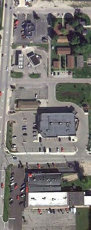
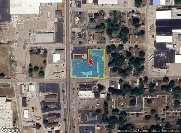
Property Record
308 S Huntington St, Syracuse, IN 46567
NEARBY LISTINGS FOR SALE OR LEASE
-
-
View all Syracuse listings for sale on LoopNet.com
Property Detail
308 S Huntington St
Warsaw, IN
Hillabolds Addition
43-04-08-400-326.000-026
8-30-184 LOTS 91-93, S PT LOTS 94, 95, 96 & PT LOTS 121-125 & LOT 126 HILLABOLDS ADD & PT VAC ALLEYS
Storebuilding
Kosciusko
X
Indiana
18085C0086D
91,126
2024
1.76 AC
2024
Indiana North Area
961001
Other Market Areas
13,023 SF
DEMOGRAPHICS near 308 S Huntington St
1 Mile
3 Mile
5 Mile
2024 Total Population
3,874
7,582
14,629
2029 Population
3,978
7,797
15,132
Pop Growth 2024-2029
+ 2.68%
+ 2.84%
+ 3.44%
Average Age
42
42
42
2024 Total Households
1,612
3,062
5,898
HH Growth 2024-2029
+ 2.67%
+ 2.97%
+ 3.63%
Median Household Inc
$59,749
$66,474
$70,972
Avg Household Size
2.30
2.40
2.40
2024 Avg HH Vehicles
2.00
2.00
2.00
Median Home Value
$168,594
$190,500
$197,903
Median Year Built
1974
1976
1978
Nearby Places
Map Layers
Map Styles
 Street
 Aerial
- Restaurants
- Banks
- Shops
- Fitness
- Groceries
PUBLIC TRANSPORTATION
AIRPORT
South Bend International
DRIVE
WALK
Distance
South Bend International
78 min
47.9 mi
Nearby Properties
Address
Land Use
TOTAL SIZE
Lot Size
Zoning
Address
Land Use
TOTAL SIZE
Lot Size
Zoning
1,156 SF
11.66 AC
IND-2
Address
Land Use
TOTAL SIZE
Lot Size
Zoning
212,370 SF
30 AC
ZO01
Address
Land Use
TOTAL SIZE
Lot Size
Zoning
45,673 SF
12.63 AC
IND-2
Address
Land Use
TOTAL SIZE
Lot Size
Zoning
41,360 SF
14.18 AC
IND-2
Address
Land Use
TOTAL SIZE
Lot Size
Zoning
76,724 SF
10.21 AC
ZO01
Address
Land Use
TOTAL SIZE
Lot Size
Zoning
12,000 SF
18.08 AC
IND-2
Address
Land Use
TOTAL SIZE
Lot Size
Zoning
1.97 AC
RESID
Address
Land Use
TOTAL SIZE
Lot Size
Zoning
113,609 SF
7.99 AC
PUBLI
Address
Land Use
TOTAL SIZE
Lot Size
Zoning
24,590 SF
3.46 AC
RESID
Address
Land Use
TOTAL SIZE
Lot Size
Zoning
100,338 SF
12.94 AC
IND-2
Address
Land Use
TOTAL SIZE
Lot Size
Zoning
56,310 SF
5.08 AC
ZO01
Address
Land Use
TOTAL SIZE
Lot Size
Zoning
21,385 SF
2.28 AC
COMME
Address
Land Use
TOTAL SIZE
Lot Size
Zoning
8,400 SF
17.73 AC
IND-2
Address
Land Use
TOTAL SIZE
Lot Size
Zoning
130,548 SF
11.87 AC
IND-2
Address
Land Use
TOTAL SIZE
Lot Size
Zoning
2.04 AC
RESID
Address
Land Use
TOTAL SIZE
Lot Size
Zoning
34,084 SF
7.22 AC
ZO01
Address
Land Use
TOTAL SIZE
Lot Size
Zoning
1,384 SF
0.41 AC
RESID
Address
Land Use
TOTAL SIZE
Lot Size
Zoning
106,706 SF
6.16 AC
IND-2
Address
Land Use
TOTAL SIZE
Lot Size
Zoning
98,920 SF
4.56 AC
IND-2
Address
Land Use
TOTAL SIZE
Lot Size
Zoning
0.87 AC
RESID
Address
Land Use
TOTAL SIZE
Lot Size
Zoning
0.28 AC
RESID
Address
Land Use
TOTAL SIZE
Lot Size
Zoning
0.45 AC
RESID
Address
Land Use
TOTAL SIZE
Lot Size
Zoning
45,012 SF
13.38 AC
ZO01
Address
Land Use
TOTAL SIZE
Lot Size
Zoning
0.31 AC
RESID
Address
Land Use
TOTAL SIZE
Lot Size
Zoning
47,121 SF
4.23 AC
IND-2
Address
Land Use
TOTAL SIZE
Lot Size
Zoning
2,834 SF
0.24 AC
RESID
Address
Land Use
TOTAL SIZE
Lot Size
Zoning
4,222 SF
9 AC
AG
Address
Land Use
TOTAL SIZE
Lot Size
Zoning
11,814 SF
12 AC
ZO01
Address
Land Use
TOTAL SIZE
Lot Size
Zoning
12,016 SF
3.20 AC
COMME
The World's #1 Commercial Real Estate Marketplace
Connect with us
© 2025 CoStar Group
The information above has been obtained from sources believed reliable. While we do not doubt its accuracy we have not verified it and make no guarantee, warranty or representation about it. It is your responsibility to independently confirm its accuracy and completeness. Any projections, opinions, assumptions, or estimates used are for example only and do not represent the current or future performance of the property. The value of this transaction to you depends on tax and other factors which should be evaluated by your tax, financial, and legal advisors. You and your advisors should conduct a careful, independent investigation of the property to determine to your satisfaction the suitability of the property for your needs.