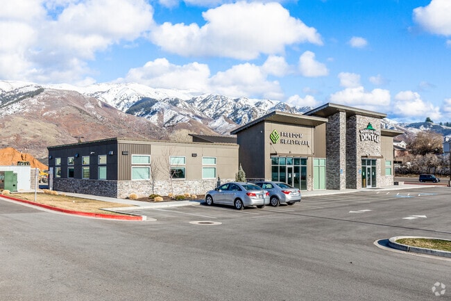
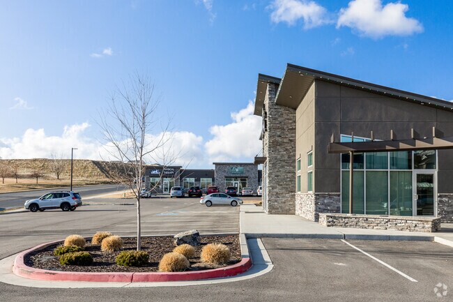
Property Record
3080 N 1700 E, Layton, UT 84040


Save to a Folder
{{folder.Name}}
{{folder.ListingIds.length}} Properties
{{folder.ListingIds.length}} Property
Create a New Folder
Property Detail
3080 N 1700 E
Ogden, UT
ALL OF LOT 3, GREYHAWK PROFESSIONAL BUSINESS PARK AMENDED. CONT. 0.90000 ACRES
09-408-0003
Davis
Realpropertynec
Utah
B and X Area of moderate flood hazard, usually the area between the limits of the 100-year and 500-year floods.
3
2025
0.90 AC
2025
Davis/Weber Counties
125103
Salt Lake City
7,568 SF
NEARBY LISTINGS FOR SALE OR LEASE
DEMOGRAPHICS near 3080 N 1700 E
1 mile
3 mile
5 mile
2025 Total Population
10,946
53,020
149,409
2030 Population
11,259
54,443
155,841
Pop Growth 2025-2030
+ 2.86%
+ 2.68%
+ 4.30%
Average Age
37
37
36
2025 Total Households
3,351
17,364
49,191
HH Growth 2025-2030
+ 2.98%
+ 2.72%
+ 4.40%
Median Household Inc
$121,887
$106,627
$98,172
Avg Household Size
3.20
3.00
3.00
2025 Avg HH Vehicles
2.00
2.00
2.00
Median Home Value
$514,936
$498,678
$498,682
Median Year Built
1993
1990
1992
Nearby Places
Map Layers
Map Styles
 Street
 Aerial
Layers
 Traffic
 Biking
Places
Listings with unknown addresses are not visible on the map
- Restaurants
- Banks
- Shops
- Fitness
- Groceries
PUBLIC TRANSPORTATION
COMMUTER RAIL
Layton (FrontRunner North - Utah Transit Authority (UTA))
Drive
Walk
Distance
Layton (FrontRunner North - Utah Transit Authority (UTA))
11 min
4.4 mi
Clearfield (FrontRunner North - Utah Transit Authority (UTA))
Drive
Walk
Distance
Clearfield (FrontRunner North - Utah Transit Authority (UTA))
10 min
4.9 mi
AIRPORT
Salt Lake City International
Drive
Walk
Distance
Salt Lake City International
39 min
29.3 mi
Nearby Properties
Address
Land Use
TOTAL SIZE
Lot Size
Zoning
Address
Land Use
TOTAL SIZE
Lot Size
Zoning
17,930 SF
17.08 AC
RM1
Address
Land Use
TOTAL SIZE
Lot Size
Zoning
3,830 SF
16.64 AC
R3
Address
Land Use
TOTAL SIZE
Lot Size
Zoning
6,840 SF
15.25 AC
RH
Address
Land Use
TOTAL SIZE
Lot Size
Zoning
100,348 SF
21.75 AC
R18
Address
Land Use
TOTAL SIZE
Lot Size
Zoning
348,048 SF
48.01 AC
A
Address
Land Use
TOTAL SIZE
Lot Size
Zoning
79,285 SF
0.01 AC
BRP
Address
Land Use
TOTAL SIZE
Lot Size
Zoning
1,484 SF
10.34 AC
Address
Land Use
TOTAL SIZE
Lot Size
Zoning
455,336 SF
22.93 AC
Address
Land Use
TOTAL SIZE
Lot Size
Zoning
107,628 SF
58.88 AC
A
Address
Land Use
TOTAL SIZE
Lot Size
Zoning
38,832 SF
6.82 AC
CP2
Address
Land Use
TOTAL SIZE
Lot Size
Zoning
7,672 SF
11.64 AC
RM1
Address
Land Use
TOTAL SIZE
Lot Size
Zoning
140,364 SF
6.47 AC
RH
Address
Land Use
TOTAL SIZE
Lot Size
Zoning
1,679 SF
7.49 AC
RM2
Address
Land Use
TOTAL SIZE
Lot Size
Zoning
176,970 SF
13.58 AC
CP3
Address
Land Use
TOTAL SIZE
Lot Size
Zoning
10,412 SF
12.68 AC
CP1
Address
Land Use
TOTAL SIZE
Lot Size
Zoning
143,836 SF
3.36 AC
B-RP
Address
Land Use
TOTAL SIZE
Lot Size
Zoning
61,864 SF
11.66 AC
Address
Land Use
TOTAL SIZE
Lot Size
Zoning
126,304 SF
4.70 AC
BRP
Address
Land Use
TOTAL SIZE
Lot Size
Zoning
132,251 SF
7.94 AC
Address
Land Use
TOTAL SIZE
Lot Size
Zoning
20,636 SF
6.30 AC
Address
Land Use
TOTAL SIZE
Lot Size
Zoning
7,098 SF
183.50 AC
A
Address
Land Use
TOTAL SIZE
Lot Size
Zoning
134,666 SF
13.50 AC
Address
Land Use
TOTAL SIZE
Lot Size
Zoning
1,618 SF
5.65 AC
RM1PRUD
Address
Land Use
TOTAL SIZE
Lot Size
Zoning
101,279 SF
9.70 AC
M1
Address
Land Use
TOTAL SIZE
Lot Size
Zoning
24,933 SF
19.51 AC
R110
Address
Land Use
TOTAL SIZE
Lot Size
Zoning
87,198 SF
0.01 AC
BRP
Address
Land Use
TOTAL SIZE
Lot Size
Zoning
3,640 SF
6.45 AC
R18
Address
Land Use
TOTAL SIZE
Lot Size
Zoning
3,200 SF
55.23 AC
RMH
Address
Land Use
TOTAL SIZE
Lot Size
Zoning
49,441 SF
1.80 AC
RM
The World's #1 Commercial Real Estate Marketplace
Connect with us
© 2026 CoStar Group
The information above has been obtained from sources believed reliable. While we do not doubt its accuracy we have not verified it and make no guarantee, warranty or representation about it. It is your responsibility to independently confirm its accuracy and completeness. Any projections, opinions, assumptions, or estimates used are for example only and do not represent the current or future performance of the property. The value of this transaction to you depends on tax and other factors which should be evaluated by your tax, financial, and legal advisors. You and your advisors should conduct a careful, independent investigation of the property to determine to your satisfaction the suitability of the property for your needs.