Property Record
30801 Drouillard Rd, Walbridge, OH 43465

Save to a Folder
{{folder.Name}}
{{folder.ListingIds.length}} Properties
{{folder.ListingIds.length}} Property
Create a New Folder
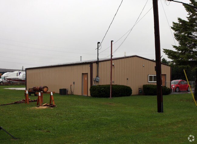
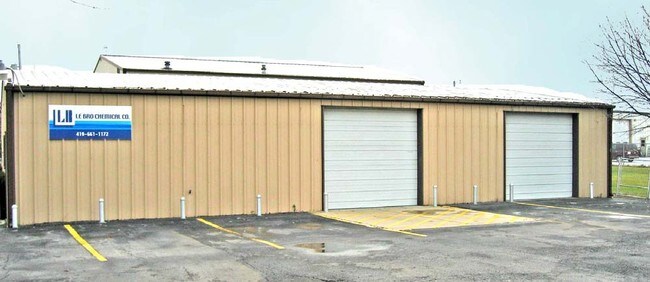
Property Detail
30801 Drouillard Rd
H31-712-050000004000
N100 E180 S1/2 N1/2 NE
Commercialnec
Wood
C and X Area of minimal flood hazard, usually depicted on FIRMs as above the 500-year flood level.
Ohio
2025
0.41 AC
2025
Perrysburg/Northwood
020800
Toledo
2,100 SF
Toledo, OH
NEARBY LISTINGS FOR SALE OR LEASE
DEMOGRAPHICS near 30801 Drouillard Rd
1 mile
3 mile
5 mile
2025 Total Population
2,910
31,595
93,430
2030 Population
2,968
31,650
94,209
Pop Growth 2025-2030
+ 1.99%
+ 0.17%
+ 0.83%
Average Age
48
40
39
2025 Total Households
1,507
13,339
39,118
HH Growth 2025-2030
+ 2.06%
+ 0.09%
+ 0.76%
Median Household Inc
$58,776
$58,785
$50,888
Avg Household Size
1.90
2.30
2.30
2025 Avg HH Vehicles
2.00
2.00
2.00
Median Home Value
$123,979
$131,830
$130,551
Median Year Built
1972
1961
1957
Nearby Places
Map Layers
Map Styles
 Street
 Aerial
Layers
 Traffic
 Biking
Places
Listings with unknown addresses are not visible on the map
- Restaurants
- Banks
- Shops
- Fitness
- Groceries
PUBLIC TRANSPORTATION
COMMUTER RAIL
Drive
Walk
Distance
13 min
5.5 mi
AIRPORT
Eugene F Kranz Toledo Express
Drive
Walk
Distance
Eugene F Kranz Toledo Express
44 min
25.2 mi
Freight Ports
Drive
Walk
Distance
19 min
7.8 mi
Nearby Properties
Address
Land Use
TOTAL SIZE
Lot Size
Zoning
Address
Land Use
TOTAL SIZE
Lot Size
Zoning
605,609 SF
9.66 AC
40-C4
Address
Land Use
TOTAL SIZE
Lot Size
Zoning
304,392 SF
17.38 AC
Address
Land Use
TOTAL SIZE
Lot Size
Zoning
313,004 SF
44.54 AC
40-C2
Address
Land Use
TOTAL SIZE
Lot Size
Zoning
497,181 SF
50.37 AC
Address
Land Use
TOTAL SIZE
Lot Size
Zoning
261,715 SF
32.11 AC
Address
Land Use
TOTAL SIZE
Lot Size
Zoning
165,710 SF
21.61 AC
Address
Land Use
TOTAL SIZE
Lot Size
Zoning
136,090 SF
4 AC
Address
Land Use
TOTAL SIZE
Lot Size
Zoning
127,658 SF
9.01 AC
40-C4
Address
Land Use
TOTAL SIZE
Lot Size
Zoning
486,615 SF
45.39 AC
Address
Land Use
TOTAL SIZE
Lot Size
Zoning
73,324 SF
16.80 AC
Address
Land Use
TOTAL SIZE
Lot Size
Zoning
73,802 SF
22.50 AC
40-R1
Address
Land Use
TOTAL SIZE
Lot Size
Zoning
170,760 SF
51.98 AC
Address
Land Use
TOTAL SIZE
Lot Size
Zoning
226,046 SF
17.15 AC
Address
Land Use
TOTAL SIZE
Lot Size
Zoning
372,803 SF
51.86 AC
Address
Land Use
TOTAL SIZE
Lot Size
Zoning
102,535 SF
20 AC
40-R2
Address
Land Use
TOTAL SIZE
Lot Size
Zoning
228,251 SF
43.08 AC
10-RD6
Address
Land Use
TOTAL SIZE
Lot Size
Zoning
145,549 SF
3.07 AC
Address
Land Use
TOTAL SIZE
Lot Size
Zoning
34 AC
40-C5
Address
Land Use
TOTAL SIZE
Lot Size
Zoning
230,074 SF
142.89 AC
40-M2
Address
Land Use
TOTAL SIZE
Lot Size
Zoning
181,347 SF
14.12 AC
40-R4
Address
Land Use
TOTAL SIZE
Lot Size
Zoning
351,114 SF
26.32 AC
10-MX
Address
Land Use
TOTAL SIZE
Lot Size
Zoning
65,683 SF
5.02 AC
10-MX
Address
Land Use
TOTAL SIZE
Lot Size
Zoning
128,000 SF
9.37 AC
Address
Land Use
TOTAL SIZE
Lot Size
Zoning
61,289 SF
2 AC
10-RD6
Address
Land Use
TOTAL SIZE
Lot Size
Zoning
123,975 SF
6.03 AC
Address
Land Use
TOTAL SIZE
Lot Size
Zoning
58,838 SF
1 AC
10-RD6
Address
Land Use
TOTAL SIZE
Lot Size
Zoning
132,284 SF
22.10 AC
Address
Land Use
TOTAL SIZE
Lot Size
Zoning
331,416 SF
30.56 AC
Address
Land Use
TOTAL SIZE
Lot Size
Zoning
199,768 SF
16.15 AC
40-C2
Address
Land Use
TOTAL SIZE
Lot Size
Zoning
77,079 SF
3.87 AC
40-R3
The World's #1 Commercial Real Estate Marketplace
Connect with us
© 2026 CoStar Group
The information above has been obtained from sources believed reliable. While we do not doubt its accuracy we have not verified it and make no guarantee, warranty or representation about it. It is your responsibility to independently confirm its accuracy and completeness. Any projections, opinions, assumptions, or estimates used are for example only and do not represent the current or future performance of the property. The value of this transaction to you depends on tax and other factors which should be evaluated by your tax, financial, and legal advisors. You and your advisors should conduct a careful, independent investigation of the property to determine to your satisfaction the suitability of the property for your needs.