No Photo
Property Record
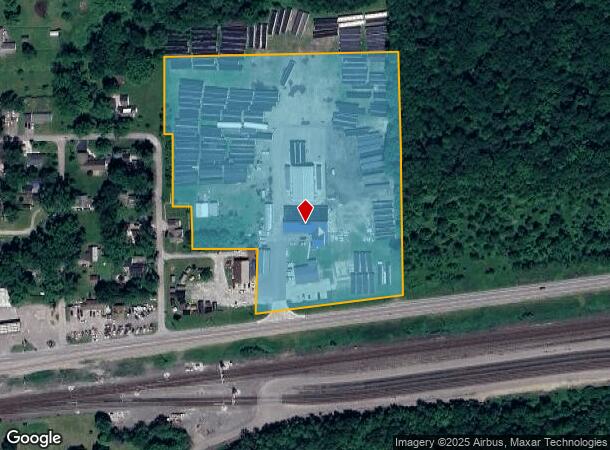
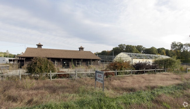
30803 Us Highway 33, Elkhart, IN 46516

NEARBY LISTINGS FOR SALE OR LEASE
-
-
View all Elkhart listings for sale on LoopNet.com
Property Detail
30803 Us Highway 33
20-05-15-105-004.000-001
PT NW NW EX 7.526A EX 1.15A SEC 15 10.60A
Lightindustrial
Elkhart
X
Indiana
18141C0241E
10.60 AC
2023
Outlying Elkhart County
2024
South Bend/Mishawaka
001901
Elkhart-Goshen, IN
18,610 SF
DEMOGRAPHICS near 30803 Us Highway 33
1 Mile
3 Mile
5 Mile
2024 Total Population
3,886
29,133
75,924
2029 Population
3,862
28,899
75,758
Pop Growth 2024-2029
(0.62%)
(0.80%)
(0.22%)
Average Age
39
40
38
2024 Total Households
1,425
10,735
28,049
HH Growth 2024-2029
(0.77%)
(0.86%)
(0.20%)
Median Household Inc
$63,016
$71,851
$58,605
Avg Household Size
2.70
2.70
2.60
2024 Avg HH Vehicles
2.00
2.00
2.00
Median Home Value
$160,603
$178,012
$161,744
Median Year Built
1967
1976
1971
Nearby Places
Map Layers
Map Styles
 Street
 Aerial
- Restaurants
- Banks
- Shops
- Fitness
- Groceries
PUBLIC TRANSPORTATION
COMMUTER RAIL
Elkhart Amtrak Station (Capitol Limited - Amtrak, Lake Shore Limited - Amtrak)
DRIVE
WALK
Distance
Elkhart Amtrak Station (Capitol Limited - Amtrak, Lake Shore Limited - Amtrak)
8 min
4.8 mi
AIRPORT
South Bend International
DRIVE
WALK
Distance
South Bend International
34 min
16.9 mi
Freight Ports
Port Milwaukee
DRIVE
WALK
Distance
Port Milwaukee
231 min
192.9 mi
Nearby Properties
Address
Land Use
TOTAL SIZE
Lot Size
Zoning
Address
Land Use
TOTAL SIZE
Lot Size
Zoning
538,127 SF
39.88 AC
ZO01
Address
Land Use
TOTAL SIZE
Lot Size
Zoning
377,169 SF
23.85 AC
ZO01
Address
Land Use
TOTAL SIZE
Lot Size
Zoning
278,692 SF
13.86 AC
ZO01
Address
Land Use
TOTAL SIZE
Lot Size
Zoning
184,212 SF
23.71 AC
ZO01
Address
Land Use
TOTAL SIZE
Lot Size
Zoning
36,851 SF
22.72 AC
Address
Land Use
TOTAL SIZE
Lot Size
Zoning
316,658 SF
27.46 AC
Address
Land Use
TOTAL SIZE
Lot Size
Zoning
144,550 SF
30.99 AC
ZO01
Address
Land Use
TOTAL SIZE
Lot Size
Zoning
240,587 SF
12 AC
ZO01
Address
Land Use
TOTAL SIZE
Lot Size
Zoning
188,176 SF
13.90 AC
ZO01
Address
Land Use
TOTAL SIZE
Lot Size
Zoning
86,252 SF
9.13 AC
ZO01
Address
Land Use
TOTAL SIZE
Lot Size
Zoning
123,595 SF
7.92 AC
Address
Land Use
TOTAL SIZE
Lot Size
Zoning
143,787 SF
8.97 AC
ZO01
Address
Land Use
TOTAL SIZE
Lot Size
Zoning
115,990 SF
11.91 AC
Address
Land Use
TOTAL SIZE
Lot Size
Zoning
81,185 SF
23.42 AC
Address
Land Use
TOTAL SIZE
Lot Size
Zoning
106,084 SF
9.11 AC
ZO01
Address
Land Use
TOTAL SIZE
Lot Size
Zoning
144,375 SF
7.87 AC
ZO01
Address
Land Use
TOTAL SIZE
Lot Size
Zoning
144,547 SF
9.77 AC
ZO01
Address
Land Use
TOTAL SIZE
Lot Size
Zoning
225,475 SF
25.63 AC
Address
Land Use
TOTAL SIZE
Lot Size
Zoning
85,660 SF
13.60 AC
ZO01
Address
Land Use
TOTAL SIZE
Lot Size
Zoning
159,677 SF
6.67 AC
Address
Land Use
TOTAL SIZE
Lot Size
Zoning
92,920 SF
3.93 AC
ZO01
Address
Land Use
TOTAL SIZE
Lot Size
Zoning
225,200 SF
25.73 AC
Address
Land Use
TOTAL SIZE
Lot Size
Zoning
182,018 SF
30.91 AC
ZO01
Address
Land Use
TOTAL SIZE
Lot Size
Zoning
155,790 SF
7.99 AC
ZO01
Address
Land Use
TOTAL SIZE
Lot Size
Zoning
136,400 SF
6.48 AC
M-1
Address
Land Use
TOTAL SIZE
Lot Size
Zoning
151,482 SF
17.72 AC
ZO01
Address
Land Use
TOTAL SIZE
Lot Size
Zoning
46,080 SF
2.64 AC
Address
Land Use
TOTAL SIZE
Lot Size
Zoning
88,343 SF
4.96 AC
ZO01
Address
Land Use
TOTAL SIZE
Lot Size
Zoning
158,745 SF
9.16 AC
Address
Land Use
TOTAL SIZE
Lot Size
Zoning
50,250 SF
16.70 AC
ZO01
The World's #1 Commercial Real Estate Marketplace
Connect with us
© 2025 CoStar Group
The information above has been obtained from sources believed reliable. While we do not doubt its accuracy we have not verified it and make no guarantee, warranty or representation about it. It is your responsibility to independently confirm its accuracy and completeness. Any projections, opinions, assumptions, or estimates used are for example only and do not represent the current or future performance of the property. The value of this transaction to you depends on tax and other factors which should be evaluated by your tax, financial, and legal advisors. You and your advisors should conduct a careful, independent investigation of the property to determine to your satisfaction the suitability of the property for your needs.