Property Record
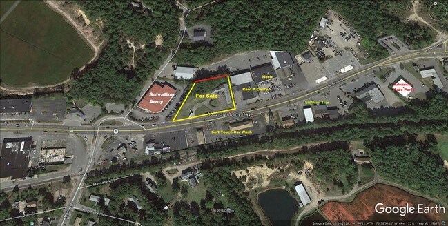
3082 Cranberry Hwy, East Wareham, MA 02538
NEARBY LISTINGS FOR SALE OR LEASE
Property Detail
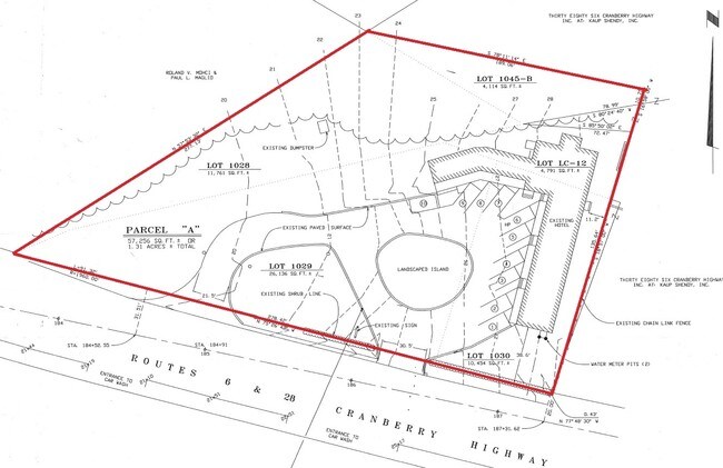
3082 Cranberry Hwy
WARE-000131-000000-001030
Plymouth
Motel
Massachusetts
X
1029
25023C0494K
0.26 AC
2025
Route 3 South
2025
Boston
545200
Boston-Cambridge-Newton, MA-NH
4,240 SF
DEMOGRAPHICS near 3082 Cranberry Hwy
1 Mile
3 Mile
5 Mile
2024 Total Population
3,005
19,363
37,564
2029 Population
2,990
19,574
38,136
Pop Growth 2024-2029
(0.50%)
+ 1.09%
+ 1.52%
Average Age
48
45
45
2024 Total Households
1,430
7,925
15,799
HH Growth 2024-2029
(0.70%)
+ 0.81%
+ 1.34%
Median Household Inc
$67,288
$75,271
$77,276
Avg Household Size
2.10
2.20
2.20
2024 Avg HH Vehicles
2.00
2.00
2.00
Median Home Value
$377,569
$401,149
$412,909
Median Year Built
1954
1958
1967
Nearby Places
- Restaurants
- Banks
- Shops
- Fitness
- Groceries
PUBLIC TRANSPORTATION
AIRPORT
Barnstable Municipal-Boardman-Polando Field
DRIVE
WALK
Distance
Barnstable Municipal-Boardman-Polando Field
39 min
24.5 mi
Freight Ports
Port of New Bedford Harbor
DRIVE
WALK
Distance
Port of New Bedford Harbor
1 min
16.4 mi
SALE & LEASE HISTORY
LISTING DATE
SALE/LEASE

Jun 23, 2017
For Sale
Jun 06, 2023
For Sale
Nearby Properties
Address
Land Use
TOTAL SIZE
Lot Size
Zoning
Address
Land Use
TOTAL SIZE
Lot Size
Zoning
1,758 SF
269.51 AC
R40
Address
Land Use
TOTAL SIZE
Lot Size
Zoning
167,599 SF
0.34 AC
Address
Land Use
TOTAL SIZE
Lot Size
Zoning
106,987 SF
3.95 AC
Address
Land Use
TOTAL SIZE
Lot Size
Zoning
654.71 AC
R40
Address
Land Use
TOTAL SIZE
Lot Size
Zoning
19.77 AC
Address
Land Use
TOTAL SIZE
Lot Size
Zoning
15,716 SF
7.85 AC
R40
Address
Land Use
TOTAL SIZE
Lot Size
Zoning
11,930 SF
4.81 AC
Address
Land Use
TOTAL SIZE
Lot Size
Zoning
67,216 SF
2.70 AC
DTD
Address
Land Use
TOTAL SIZE
Lot Size
Zoning
68.53 AC
R40
Address
Land Use
TOTAL SIZE
Lot Size
Zoning
12,812 SF
19.12 AC
Address
Land Use
TOTAL SIZE
Lot Size
Zoning
125,493 SF
5.59 AC
DTD
Address
Land Use
TOTAL SIZE
Lot Size
Zoning
8.89 AC
Address
Land Use
TOTAL SIZE
Lot Size
Zoning
116,476 SF
13.22 AC
Address
Land Use
TOTAL SIZE
Lot Size
Zoning
60.89 AC
Address
Land Use
TOTAL SIZE
Lot Size
Zoning
27,958 SF
5.85 AC
R40
Address
Land Use
TOTAL SIZE
Lot Size
Zoning
4,214 SF
13.85 AC
Address
Land Use
TOTAL SIZE
Lot Size
Zoning
117,814 SF
16.49 AC
Address
Land Use
TOTAL SIZE
Lot Size
Zoning
26,053 SF
1.26 AC
Address
Land Use
TOTAL SIZE
Lot Size
Zoning
17.47 AC
Address
Land Use
TOTAL SIZE
Lot Size
Zoning
4,959 SF
2.30 AC
Address
Land Use
TOTAL SIZE
Lot Size
Zoning
30,195 SF
0.82 AC
Address
Land Use
TOTAL SIZE
Lot Size
Zoning
65,856 SF
6.70 AC
Address
Land Use
TOTAL SIZE
Lot Size
Zoning
24,100 SF
3.03 AC
Address
Land Use
TOTAL SIZE
Lot Size
Zoning
2,024 SF
10.57 AC
R40
Address
Land Use
TOTAL SIZE
Lot Size
Zoning
32.24 AC
Address
Land Use
TOTAL SIZE
Lot Size
Zoning
2.44 AC
R40
Address
Land Use
TOTAL SIZE
Lot Size
Zoning
Address
Land Use
TOTAL SIZE
Lot Size
Zoning
7,856 SF
5.34 AC
R40
Address
Land Use
TOTAL SIZE
Lot Size
Zoning
21,240 SF
2.79 AC
Address
Land Use
TOTAL SIZE
Lot Size
Zoning
The World's #1 Commercial Real Estate Marketplace
Connect with us
© 2025 CoStar Group
The information above has been obtained from sources believed reliable. While we do not doubt its accuracy we have not verified it and make no guarantee, warranty or representation about it. It is your responsibility to independently confirm its accuracy and completeness. Any projections, opinions, assumptions, or estimates used are for example only and do not represent the current or future performance of the property. The value of this transaction to you depends on tax and other factors which should be evaluated by your tax, financial, and legal advisors. You and your advisors should conduct a careful, independent investigation of the property to determine to your satisfaction the suitability of the property for your needs.