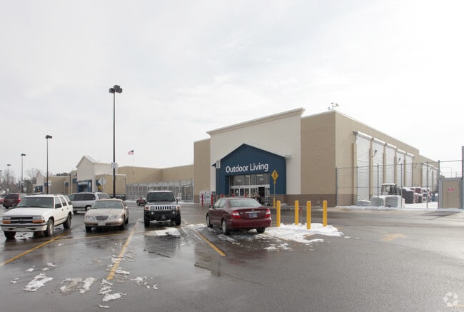
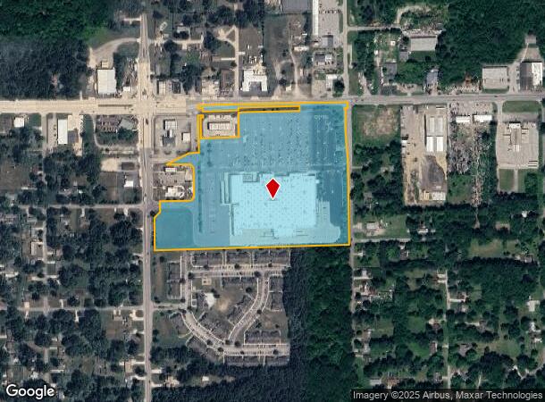
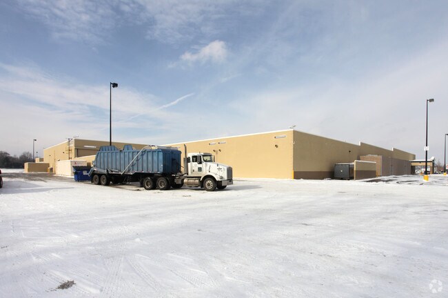
Property Record
30830 Old Us 20, Elkhart, IN 46514
NEARBY LISTINGS FOR SALE OR LEASE
-
-
No Photo
-
-
View all Elkhart listings for sale on LoopNet.com
Property Detail
30830 Old Us 20
20-05-03-301-016.000-005
N PT W1/2 SW1/4 EX ETC EX ..279A ROW SEC 3 23.711A (TIF 122)
Departmentstore
Elkhart
X
Indiana
18141C0241E
23.71 AC
2024
Outlying Elkhart County
2025
South Bend/Mishawaka
001501
Elkhart-Goshen, IN
189,262 SF
DEMOGRAPHICS near 30830 Old Us 20
1 Mile
3 Mile
5 Mile
2024 Total Population
3,245
31,370
83,053
2029 Population
3,224
31,140
82,793
Pop Growth 2024-2029
(0.65%)
(0.73%)
(0.31%)
Average Age
39
39
38
2024 Total Households
1,184
11,406
30,834
HH Growth 2024-2029
(0.68%)
(0.82%)
(0.28%)
Median Household Inc
$68,198
$72,153
$60,509
Avg Household Size
2.70
2.70
2.60
2024 Avg HH Vehicles
2.00
2.00
2.00
Median Home Value
$172,689
$179,559
$171,732
Median Year Built
1978
1978
1973
Nearby Places
Map Layers
Map Styles
 Street
 Aerial
- Restaurants
- Banks
- Shops
- Fitness
- Groceries
PUBLIC TRANSPORTATION
AIRPORT
South Bend International
DRIVE
WALK
Distance
South Bend International
35 min
16.4 mi
Nearby Properties
Address
Land Use
TOTAL SIZE
Lot Size
Zoning
Address
Land Use
TOTAL SIZE
Lot Size
Zoning
300,000 SF
68.80 AC
ZO01
Address
Land Use
TOTAL SIZE
Lot Size
Zoning
377,169 SF
23.85 AC
ZO01
Address
Land Use
TOTAL SIZE
Lot Size
Zoning
36,851 SF
22.72 AC
Address
Land Use
TOTAL SIZE
Lot Size
Zoning
83,856 SF
54.56 AC
ZO01
Address
Land Use
TOTAL SIZE
Lot Size
Zoning
277,504 SF
18.61 AC
ZO01
Address
Land Use
TOTAL SIZE
Lot Size
Zoning
316,658 SF
27.46 AC
Address
Land Use
TOTAL SIZE
Lot Size
Zoning
144,000 SF
18.31 AC
ZO01
Address
Land Use
TOTAL SIZE
Lot Size
Zoning
188,176 SF
12.75 AC
ZO01
Address
Land Use
TOTAL SIZE
Lot Size
Zoning
86,252 SF
9.13 AC
ZO01
Address
Land Use
TOTAL SIZE
Lot Size
Zoning
51,620 SF
30.21 AC
ZO01
Address
Land Use
TOTAL SIZE
Lot Size
Zoning
123,595 SF
7.92 AC
Address
Land Use
TOTAL SIZE
Lot Size
Zoning
181,986 SF
30.91 AC
ZO01
Address
Land Use
TOTAL SIZE
Lot Size
Zoning
115,990 SF
11.91 AC
Address
Land Use
TOTAL SIZE
Lot Size
Zoning
61,877 SF
13.54 AC
Address
Land Use
TOTAL SIZE
Lot Size
Zoning
81,185 SF
23.42 AC
Address
Land Use
TOTAL SIZE
Lot Size
Zoning
159,677 SF
12.76 AC
Address
Land Use
TOTAL SIZE
Lot Size
Zoning
106,084 SF
9.11 AC
ZO01
Address
Land Use
TOTAL SIZE
Lot Size
Zoning
120,535 SF
14 AC
Address
Land Use
TOTAL SIZE
Lot Size
Zoning
136,400 SF
6.48 AC
M-1
Address
Land Use
TOTAL SIZE
Lot Size
Zoning
225,200 SF
25.73 AC
Address
Land Use
TOTAL SIZE
Lot Size
Zoning
68,750 SF
33.38 AC
ZO01
Address
Land Use
TOTAL SIZE
Lot Size
Zoning
37,735 SF
8.25 AC
Address
Land Use
TOTAL SIZE
Lot Size
Zoning
46,080 SF
2.64 AC
Address
Land Use
TOTAL SIZE
Lot Size
Zoning
49,293 SF
87 SF
Address
Land Use
TOTAL SIZE
Lot Size
Zoning
50,250 SF
16.70 AC
ZO01
Address
Land Use
TOTAL SIZE
Lot Size
Zoning
24,086 SF
1.90 AC
ZO01
Address
Land Use
TOTAL SIZE
Lot Size
Zoning
50,057 SF
10 AC
ZO01
Address
Land Use
TOTAL SIZE
Lot Size
Zoning
30,470 SF
20 AC
Address
Land Use
TOTAL SIZE
Lot Size
Zoning
47,240 SF
6.66 AC
The World's #1 Commercial Real Estate Marketplace
Connect with us
© 2026 CoStar Group
The information above has been obtained from sources believed reliable. While we do not doubt its accuracy we have not verified it and make no guarantee, warranty or representation about it. It is your responsibility to independently confirm its accuracy and completeness. Any projections, opinions, assumptions, or estimates used are for example only and do not represent the current or future performance of the property. The value of this transaction to you depends on tax and other factors which should be evaluated by your tax, financial, and legal advisors. You and your advisors should conduct a careful, independent investigation of the property to determine to your satisfaction the suitability of the property for your needs.