Property Record
3085 Bridge St Nw, Saint Francis, MN 55070


NEARBY LISTINGS FOR SALE OR LEASE
-
-
View all Saint Francis listings for sale on LoopNet.com
Property Detail
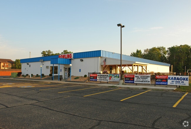
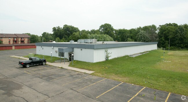
3085 Bridge St Nw
33-34-24-33-0010
THAT PRT OF SW1/4 OF SW1/4 OF SEC 33 TWP 34 RGE 24 DESC AS FOL: COM AT INTER OF NLY LINE OF CSAH NO 24 WITH E LINE OF SD 1/4,1/4, TH N ALG SD E LINE 635 FT, TH W AT RT ANG 300 FT, TH SWLY TO A PT ON S D R/W LINE 475 FT W OF E LINE OF SD 1/4, 1/4 & PO
Commercialnec
Anoka
X
Minnesota
27003C0065E
2.20 AC
2025
Coon Rapids
2025
Minneapolis/St Paul
050108
Minneapolis-St. Paul-Bloomington, MN-WI
12,800 SF
DEMOGRAPHICS near 3085 Bridge St Nw
1 Mile
3 Mile
5 Mile
2024 Total Population
4,095
11,927
20,255
2029 Population
4,262
12,433
21,077
Pop Growth 2024-2029
+ 4.08%
+ 4.24%
+ 4.06%
Average Age
36
38
39
2024 Total Households
1,471
4,205
7,106
HH Growth 2024-2029
+ 4.08%
+ 4.30%
+ 4.12%
Median Household Inc
$92,012
$94,959
$101,016
Avg Household Size
2.80
2.80
2.80
2024 Avg HH Vehicles
2.00
2.00
3.00
Median Home Value
$269,253
$300,534
$328,921
Median Year Built
2000
1996
1993
Nearby Places
Map Layers
Map Styles
 Street
 Aerial
- Restaurants
- Banks
- Shops
- Fitness
- Groceries
Nearby Properties
Address
Land Use
TOTAL SIZE
Lot Size
Zoning
Address
Land Use
TOTAL SIZE
Lot Size
Zoning
228,826 SF
56.32 AC
Address
Land Use
TOTAL SIZE
Lot Size
Zoning
68,136 SF
26.79 AC
Address
Land Use
TOTAL SIZE
Lot Size
Zoning
104 SF
2.79 AC
Address
Land Use
TOTAL SIZE
Lot Size
Zoning
2,720 SF
2.03 AC
Address
Land Use
TOTAL SIZE
Lot Size
Zoning
Address
Land Use
TOTAL SIZE
Lot Size
Zoning
45,652 SF
38.11 AC
Address
Land Use
TOTAL SIZE
Lot Size
Zoning
60,159 SF
6.42 AC
Address
Land Use
TOTAL SIZE
Lot Size
Zoning
61,276 SF
1.84 AC
Address
Land Use
TOTAL SIZE
Lot Size
Zoning
894 SF
4 AC
Address
Land Use
TOTAL SIZE
Lot Size
Zoning
1,512 SF
5.01 AC
Address
Land Use
TOTAL SIZE
Lot Size
Zoning
16,213 SF
1.85 AC
Address
Land Use
TOTAL SIZE
Lot Size
Zoning
20,138 SF
2.61 AC
Address
Land Use
TOTAL SIZE
Lot Size
Zoning
1,292 SF
16.10 AC
Address
Land Use
TOTAL SIZE
Lot Size
Zoning
19,752 SF
2.09 AC
Address
Land Use
TOTAL SIZE
Lot Size
Zoning
24,438 SF
1.25 AC
Address
Land Use
TOTAL SIZE
Lot Size
Zoning
7,294 SF
Address
Land Use
TOTAL SIZE
Lot Size
Zoning
20,535 SF
1.15 AC
Address
Land Use
TOTAL SIZE
Lot Size
Zoning
30,732 SF
2.44 AC
Address
Land Use
TOTAL SIZE
Lot Size
Zoning
Address
Land Use
TOTAL SIZE
Lot Size
Zoning
13,580 SF
1.71 AC
Address
Land Use
TOTAL SIZE
Lot Size
Zoning
11,264 SF
1.85 AC
Address
Land Use
TOTAL SIZE
Lot Size
Zoning
1,632 SF
257 AC
Address
Land Use
TOTAL SIZE
Lot Size
Zoning
7,451 SF
1.55 AC
Address
Land Use
TOTAL SIZE
Lot Size
Zoning
2,021 SF
61 AC
Address
Land Use
TOTAL SIZE
Lot Size
Zoning
17,204 SF
5.90 AC
Address
Land Use
TOTAL SIZE
Lot Size
Zoning
12,204 SF
0.82 AC
Address
Land Use
TOTAL SIZE
Lot Size
Zoning
12,204 SF
0.87 AC
Address
Land Use
TOTAL SIZE
Lot Size
Zoning
9,100 SF
1.20 AC
Address
Land Use
TOTAL SIZE
Lot Size
Zoning
Address
Land Use
TOTAL SIZE
Lot Size
Zoning
10,640 SF
The World's #1 Commercial Real Estate Marketplace
Connect with us
© 2026 CoStar Group
The information above has been obtained from sources believed reliable. While we do not doubt its accuracy we have not verified it and make no guarantee, warranty or representation about it. It is your responsibility to independently confirm its accuracy and completeness. Any projections, opinions, assumptions, or estimates used are for example only and do not represent the current or future performance of the property. The value of this transaction to you depends on tax and other factors which should be evaluated by your tax, financial, and legal advisors. You and your advisors should conduct a careful, independent investigation of the property to determine to your satisfaction the suitability of the property for your needs.