Property Record
3085 Scioto Darby Executive Ct, Hilliard, OH 43026


NEARBY LISTINGS FOR SALE OR LEASE
Property Detail
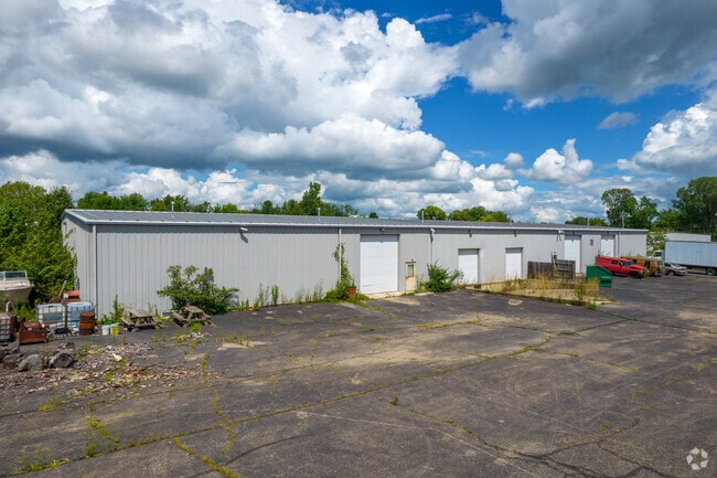
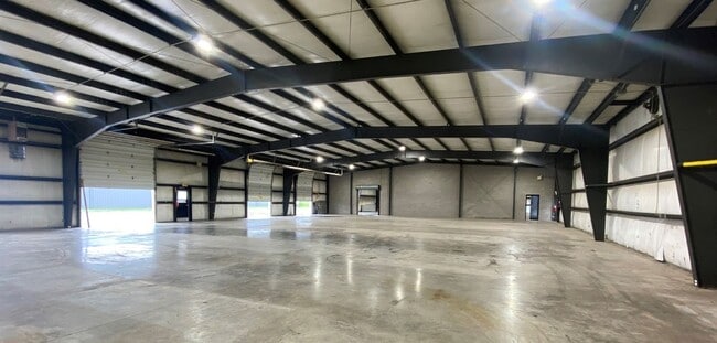
3085 Scioto Darby Executive Ct
560-244711
Whitacre Partition
Warehouse
SCIOTO-DARBY CK RD ENTRY 547 3.00 ACRES
X
Franklin
39049C0163K
Ohio
2024
3 AC
2024
Hilliard
007957
Columbus
9,975 SF
Columbus, OH
DEMOGRAPHICS near 3085 Scioto Darby Executive Ct
1 Mile
3 Mile
5 Mile
2024 Total Population
4,881
83,737
241,858
2029 Population
4,879
83,391
241,232
Pop Growth 2024-2029
(0.04%)
(0.41%)
(0.26%)
Average Age
42
38
37
2024 Total Households
2,243
33,996
104,025
HH Growth 2024-2029
+ 0.27%
(0.36%)
(0.32%)
Median Household Inc
$92,480
$97,923
$80,206
Avg Household Size
2.10
2.40
2.30
2024 Avg HH Vehicles
2.00
2.00
2.00
Median Home Value
$265,400
$293,925
$296,332
Median Year Built
1987
1990
1985
Nearby Places
Map Layers
Map Styles
 Street
 Aerial
- Restaurants
- Banks
- Shops
- Fitness
- Groceries
PUBLIC TRANSPORTATION
AIRPORT
John Glenn Columbus International
DRIVE
WALK
Distance
John Glenn Columbus International
25 min
15.7 mi
Rickenbacker International
DRIVE
WALK
Distance
Rickenbacker International
32 min
22.5 mi
SALE & LEASE HISTORY
LISTING DATE
SALE/LEASE

Jul 26, 2022
For Lease
Aug 29, 2019
For Sale
Nearby Properties
Address
Land Use
TOTAL SIZE
Lot Size
Zoning
Address
Land Use
TOTAL SIZE
Lot Size
Zoning
327,525 SF
70.58 AC
Address
Land Use
TOTAL SIZE
Lot Size
Zoning
529,001 SF
28.39 AC
Address
Land Use
TOTAL SIZE
Lot Size
Zoning
961,554 SF
75.09 AC
Address
Land Use
TOTAL SIZE
Lot Size
Zoning
329,215 SF
8.33 AC
Address
Land Use
TOTAL SIZE
Lot Size
Zoning
34,521 SF
29.23 AC
Address
Land Use
TOTAL SIZE
Lot Size
Zoning
91,413 SF
0.14 AC
Address
Land Use
TOTAL SIZE
Lot Size
Zoning
160,760 SF
14.29 AC
Address
Land Use
TOTAL SIZE
Lot Size
Zoning
50,837 SF
10.12 AC
Address
Land Use
TOTAL SIZE
Lot Size
Zoning
70,995 SF
38.78 AC
Address
Land Use
TOTAL SIZE
Lot Size
Zoning
255,902 SF
8.15 AC
Address
Land Use
TOTAL SIZE
Lot Size
Zoning
195,867 SF
14.13 AC
Address
Land Use
TOTAL SIZE
Lot Size
Zoning
110,344 SF
19.06 AC
Address
Land Use
TOTAL SIZE
Lot Size
Zoning
566,334 SF
58.62 AC
Address
Land Use
TOTAL SIZE
Lot Size
Zoning
446,488 SF
45.12 AC
Address
Land Use
TOTAL SIZE
Lot Size
Zoning
271,295 SF
14.75 AC
Address
Land Use
TOTAL SIZE
Lot Size
Zoning
142,979 SF
6.50 AC
Address
Land Use
TOTAL SIZE
Lot Size
Zoning
108,828 SF
23.51 AC
Address
Land Use
TOTAL SIZE
Lot Size
Zoning
293,744 SF
20.12 AC
Address
Land Use
TOTAL SIZE
Lot Size
Zoning
98,316 SF
10.81 AC
Address
Land Use
TOTAL SIZE
Lot Size
Zoning
157,875 SF
8.51 AC
Address
Land Use
TOTAL SIZE
Lot Size
Zoning
156,030 SF
31.29 AC
Address
Land Use
TOTAL SIZE
Lot Size
Zoning
67,192 SF
17.70 AC
Address
Land Use
TOTAL SIZE
Lot Size
Zoning
69,650 SF
15.15 AC
Address
Land Use
TOTAL SIZE
Lot Size
Zoning
126,656 SF
15.83 AC
Address
Land Use
TOTAL SIZE
Lot Size
Zoning
429,544 SF
23.21 AC
Address
Land Use
TOTAL SIZE
Lot Size
Zoning
67,133 SF
16.67 AC
Address
Land Use
TOTAL SIZE
Lot Size
Zoning
84,002 SF
4.08 AC
Address
Land Use
TOTAL SIZE
Lot Size
Zoning
55,758 SF
7.83 AC
Address
Land Use
TOTAL SIZE
Lot Size
Zoning
64,133 SF
21.83 AC
Address
Land Use
TOTAL SIZE
Lot Size
Zoning
173,002 SF
7.16 AC
The World's #1 Commercial Real Estate Marketplace
Connect with us
© 2025 CoStar Group
The information above has been obtained from sources believed reliable. While we do not doubt its accuracy we have not verified it and make no guarantee, warranty or representation about it. It is your responsibility to independently confirm its accuracy and completeness. Any projections, opinions, assumptions, or estimates used are for example only and do not represent the current or future performance of the property. The value of this transaction to you depends on tax and other factors which should be evaluated by your tax, financial, and legal advisors. You and your advisors should conduct a careful, independent investigation of the property to determine to your satisfaction the suitability of the property for your needs.