Property Record
3086 Cooper St, Punta Gorda, FL 33950

NEARBY LISTINGS FOR SALE OR LEASE
-
-
View all Punta Gorda listings for sale on LoopNet.com
Property Detail
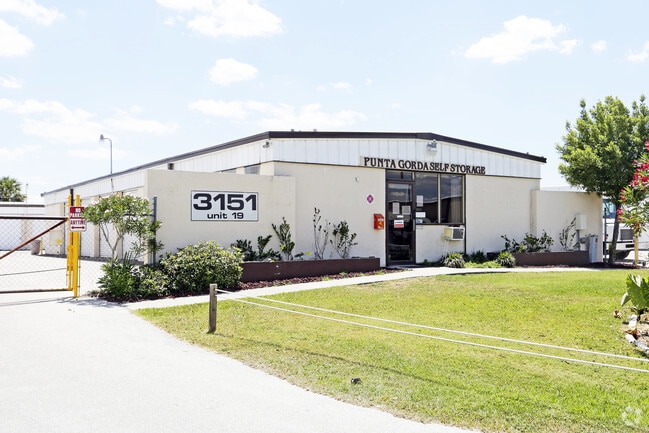
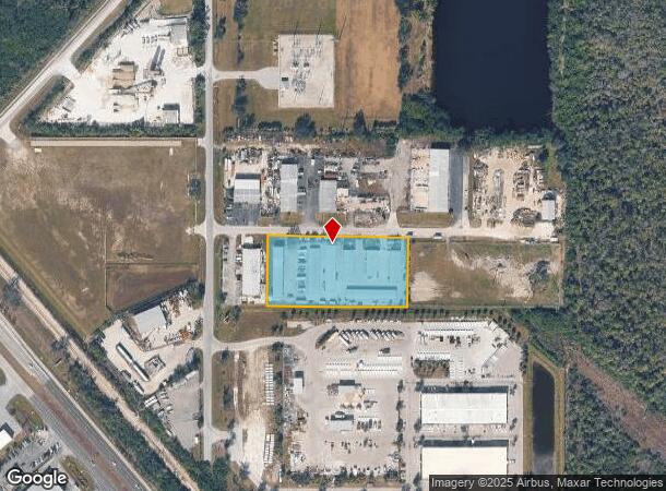
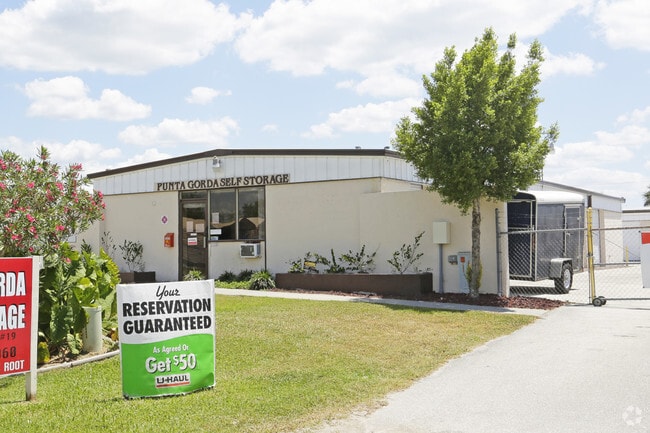
3086 Cooper St
412317106001
Of Coral Ridge Commercial Condo
Publicstorage
17 41 23 P21 2.32 AC M/L COM AT NW COR SEC 21 TH S 1972.22 FT TH E 25 FT TO NW COR OF CORAL RIDGE COMMERCIAL CONDO PH XIII AND E ROW LINE COOPER ST TH S ALNG E ROW LINE 318 FT E 165 FT TO POB TH CONT E 450 FT FT S 223.98 FT W 450 FT N 223.98 FT TO PO
AE
Charlotte
12015C0241G
Florida
2024
2.31 AC
2025
Charlotte County
010302
Southwest Florida
27,450 SF
Punta Gorda, FL
DEMOGRAPHICS near 3086 Cooper St
1 Mile
3 Mile
5 Mile
2024 Total Population
5,076
28,292
44,826
2029 Population
6,075
34,119
53,980
Pop Growth 2024-2029
+ 19.68%
+ 20.60%
+ 20.42%
Average Age
56
59
57
2024 Total Households
2,569
14,091
22,057
HH Growth 2024-2029
+ 19.66%
+ 20.80%
+ 20.68%
Median Household Inc
$50,401
$64,235
$59,660
Avg Household Size
2.00
1.90
2.00
2024 Avg HH Vehicles
2.00
2.00
2.00
Median Home Value
$263,859
$401,789
$325,969
Median Year Built
1995
1994
1991
Nearby Places
Map Layers
Map Styles
 Street
 Aerial
- Restaurants
- Banks
- Shops
- Fitness
- Groceries
PUBLIC TRANSPORTATION
AIRPORT
Punta Gorda
DRIVE
WALK
Distance
Punta Gorda
8 min
3.5 mi
Freight Ports
Port Manatee
DRIVE
WALK
Distance
Port Manatee
90 min
74.0 mi
Nearby Properties
Address
Land Use
TOTAL SIZE
Lot Size
Zoning
Address
Land Use
TOTAL SIZE
Lot Size
Zoning
349,844 SF
78.47 AC
P
Address
Land Use
TOTAL SIZE
Lot Size
Zoning
164,121 SF
44.20 AC
ECAP
Address
Land Use
TOTAL SIZE
Lot Size
Zoning
77,154 SF
10.30 AC
CC
Address
Land Use
TOTAL SIZE
Lot Size
Zoning
161,439 SF
171 AC
RE1
Address
Land Use
TOTAL SIZE
Lot Size
Zoning
265,949 SF
22.80 AC
PD-CC
Address
Land Use
TOTAL SIZE
Lot Size
Zoning
253,440 SF
30.47 AC
ECAP
Address
Land Use
TOTAL SIZE
Lot Size
Zoning
378,000 SF
29.24 AC
ECAP
Address
Land Use
TOTAL SIZE
Lot Size
Zoning
345,043 SF
33.12 AC
ECAP
Address
Land Use
TOTAL SIZE
Lot Size
Zoning
47,443 SF
7.94 AC
CC
Address
Land Use
TOTAL SIZE
Lot Size
Zoning
62,415 SF
281.65 AC
ECAP
Address
Land Use
TOTAL SIZE
Lot Size
Zoning
114,417 SF
4.36 AC
GM-15
Address
Land Use
TOTAL SIZE
Lot Size
Zoning
15,253 SF
13.27 AC
P
Address
Land Use
TOTAL SIZE
Lot Size
Zoning
198,916 SF
25.79 AC
HC
Address
Land Use
TOTAL SIZE
Lot Size
Zoning
208,560 SF
36.69 AC
PD-GM
Address
Land Use
TOTAL SIZE
Lot Size
Zoning
385,350 SF
374.81 AC
ECAP
Address
Land Use
TOTAL SIZE
Lot Size
Zoning
134,308 SF
16 AC
RSF3.5
Address
Land Use
TOTAL SIZE
Lot Size
Zoning
142,812 SF
7.89 AC
HC
Address
Land Use
TOTAL SIZE
Lot Size
Zoning
6,313 SF
15.49 AC
P
Address
Land Use
TOTAL SIZE
Lot Size
Zoning
73,095 SF
5 AC
NC
Address
Land Use
TOTAL SIZE
Lot Size
Zoning
44,185 SF
1.22 AC
CC
Address
Land Use
TOTAL SIZE
Lot Size
Zoning
25,356 SF
1.40 AC
CC
Address
Land Use
TOTAL SIZE
Lot Size
Zoning
96,845 SF
17.62 AC
HC
Address
Land Use
TOTAL SIZE
Lot Size
Zoning
8,406 SF
31.48 AC
ECAP
Address
Land Use
TOTAL SIZE
Lot Size
Zoning
82,379 SF
0.88 AC
CC
Address
Land Use
TOTAL SIZE
Lot Size
Zoning
12,159 SF
0.56 AC
CC
Address
Land Use
TOTAL SIZE
Lot Size
Zoning
24,880 SF
84.50 AC
PKR
Address
Land Use
TOTAL SIZE
Lot Size
Zoning
43,755 SF
8.19 AC
CC
Address
Land Use
TOTAL SIZE
Lot Size
Zoning
30,472 SF
3.19 AC
NR-10
Address
Land Use
TOTAL SIZE
Lot Size
Zoning
30,940 SF
0.42 AC
NC
Address
Land Use
TOTAL SIZE
Lot Size
Zoning
68,492 SF
6.38 AC
HC
The World's #1 Commercial Real Estate Marketplace
Connect with us
© 2025 CoStar Group
The information above has been obtained from sources believed reliable. While we do not doubt its accuracy we have not verified it and make no guarantee, warranty or representation about it. It is your responsibility to independently confirm its accuracy and completeness. Any projections, opinions, assumptions, or estimates used are for example only and do not represent the current or future performance of the property. The value of this transaction to you depends on tax and other factors which should be evaluated by your tax, financial, and legal advisors. You and your advisors should conduct a careful, independent investigation of the property to determine to your satisfaction the suitability of the property for your needs.