Property Record
3086 Pheasant Run Dr, Lafayette, IN 47909
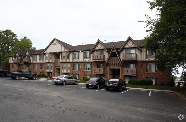

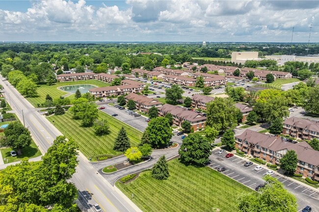
Property Detail
3086 Pheasant Run Dr
Lafayette-West Lafayette, IN
PT NW FR SEC 3 TWP 22 R4 35.481 A
79-11-03-176-003.000-033
TIPPECANOE
Apartment
Indiana
C and X Area of minimal flood hazard, usually depicted on FIRMs as above the 500-year flood level.
1
2024
174 SF
2024
Lafayette/Kokomo
001702
Other Market Areas
518,808 SF
NEARBY LISTINGS FOR SALE OR LEASE
DEMOGRAPHICS near 3086 Pheasant Run Dr
1 mile
3 mile
5 mile
2025 Total Population
7,793
55,700
128,664
2030 Population
7,753
55,947
132,588
Pop Growth 2025-2030
(0.51%)
+ 0.44%
+ 3.05%
Average Age
37
37
35
2025 Total Households
3,365
23,628
50,324
HH Growth 2025-2030
(0.27%)
+ 0.58%
+ 3.46%
Median Household Inc
$60,296
$62,008
$55,523
Avg Household Size
2.30
2.30
2.20
2025 Avg HH Vehicles
2.00
2.00
2.00
Median Home Value
$167,377
$202,454
$236,789
Median Year Built
1970
1977
1985
Nearby Places
Map Layers
Map Styles
 Street
 Aerial
Transit
 Traffic
 Biking
Places
Listings with unknown addresses are not visible on the map
- Restaurants
- Banks
- Shops
- Fitness
- Groceries
PUBLIC TRANSPORTATION
COMMUTER RAIL
Lafayette Amtrak Station (Cardinal - Amtrak)
Drive
Walk
Distance
Lafayette Amtrak Station (Cardinal - Amtrak)
9 min
4.5 mi
Freight Ports
Port Milwaukee
Drive
Walk
Distance
Port Milwaukee
254 min
209.8 mi
Nearby Properties
Address
Land Use
TOTAL SIZE
Lot Size
Zoning
Address
Land Use
TOTAL SIZE
Lot Size
Zoning
2,199,963 SF
0.06 AC
Address
Land Use
TOTAL SIZE
Lot Size
Zoning
68,943 SF
0.01 AC
Address
Land Use
TOTAL SIZE
Lot Size
Zoning
689,020 SF
0.01 AC
Address
Land Use
TOTAL SIZE
Lot Size
Zoning
298,339 SF
19.58 AC
R1
Address
Land Use
TOTAL SIZE
Lot Size
Zoning
117,351 SF
44 SF
Address
Land Use
TOTAL SIZE
Lot Size
Zoning
210,829 SF
87 SF
Address
Land Use
TOTAL SIZE
Lot Size
Zoning
298,050 SF
50.91 AC
Address
Land Use
TOTAL SIZE
Lot Size
Zoning
32.01 AC
Address
Land Use
TOTAL SIZE
Lot Size
Zoning
270,827 SF
34.90 AC
Address
Land Use
TOTAL SIZE
Lot Size
Zoning
1,449,360 SF
0.01 AC
Address
Land Use
TOTAL SIZE
Lot Size
Zoning
205,701 SF
1.27 AC
Address
Land Use
TOTAL SIZE
Lot Size
Zoning
77,226 SF
0.01 AC
Address
Land Use
TOTAL SIZE
Lot Size
Zoning
164,234 SF
0.88 AC
Address
Land Use
TOTAL SIZE
Lot Size
Zoning
222,276 SF
0.31 AC
Address
Land Use
TOTAL SIZE
Lot Size
Zoning
203,830 SF
18.73 AC
Address
Land Use
TOTAL SIZE
Lot Size
Zoning
316,008 SF
27.04 AC
Address
Land Use
TOTAL SIZE
Lot Size
Zoning
267,379 SF
87 SF
Address
Land Use
TOTAL SIZE
Lot Size
Zoning
140,973 SF
131 SF
Address
Land Use
TOTAL SIZE
Lot Size
Zoning
135,090 SF
0.80 AC
Address
Land Use
TOTAL SIZE
Lot Size
Zoning
340,790 SF
131 SF
Address
Land Use
TOTAL SIZE
Lot Size
Zoning
70,686 SF
25.67 AC
Address
Land Use
TOTAL SIZE
Lot Size
Zoning
500,000 SF
174 SF
Address
Land Use
TOTAL SIZE
Lot Size
Zoning
1,409,410 SF
170.04 AC
Address
Land Use
TOTAL SIZE
Lot Size
Zoning
295,530 SF
23.01 AC
Address
Land Use
TOTAL SIZE
Lot Size
Zoning
109,515 SF
0.85 AC
Address
Land Use
TOTAL SIZE
Lot Size
Zoning
70,889 SF
44 SF
Address
Land Use
TOTAL SIZE
Lot Size
Zoning
109,876 SF
0.61 AC
Address
Land Use
TOTAL SIZE
Lot Size
Zoning
115,514 SF
44 SF
Address
Land Use
TOTAL SIZE
Lot Size
Zoning
245,034 SF
1.39 AC
The World's #1 Commercial Real Estate Marketplace
Connect with us
© 2026 CoStar Group
The information above has been obtained from sources believed reliable. While we do not doubt its accuracy we have not verified it and make no guarantee, warranty or representation about it. It is your responsibility to independently confirm its accuracy and completeness. Any projections, opinions, assumptions, or estimates used are for example only and do not represent the current or future performance of the property. The value of this transaction to you depends on tax and other factors which should be evaluated by your tax, financial, and legal advisors. You and your advisors should conduct a careful, independent investigation of the property to determine to your satisfaction the suitability of the property for your needs.