Property Record
3088 N Highway 127, Albany, KY 42602

NEARBY LISTINGS FOR SALE OR LEASE
-
-
View all Albany listings for lease on LoopNet.com
Property Detail
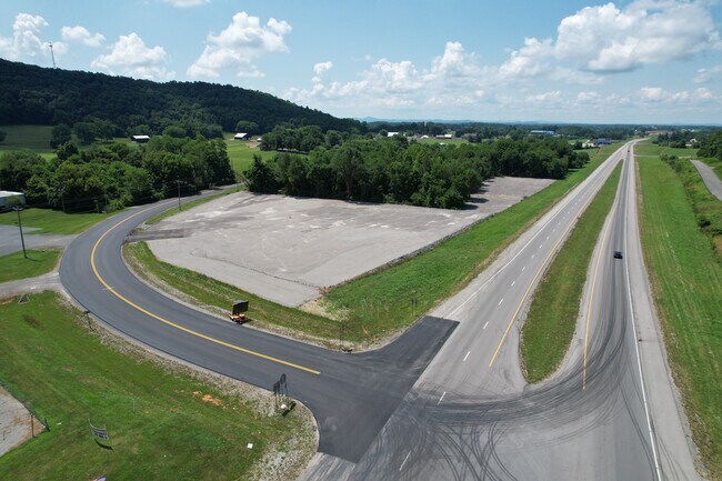
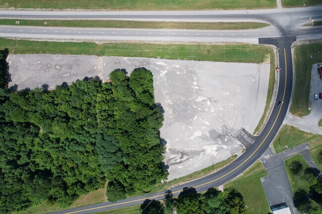
3088 N Highway 127
Commercialnec
COMMERCIAL BLDGS & LOT ON HWY 127
A
Clinton
21057C0275D
Kentucky
2024
17.50 AC
2024
Kentucky East Area
970100
Other Market Areas
1,871 SF
035-00-00-003.00
DEMOGRAPHICS near 3088 N Highway 127
1 Mile
3 Mile
5 Mile
2024 Total Population
2,118
3,581
5,644
2029 Population
2,082
3,519
5,550
Pop Growth 2024-2029
(1.70%)
(1.73%)
(1.67%)
Average Age
42
41
42
2024 Total Households
931
1,555
2,427
HH Growth 2024-2029
(1.61%)
(1.67%)
(1.57%)
Median Household Inc
$33,917
$35,062
$35,517
Avg Household Size
2.20
2.20
2.30
2024 Avg HH Vehicles
2.00
2.00
2.00
Median Home Value
$78,550
$80,702
$84,602
Median Year Built
1980
1982
1984
Nearby Places
Map Layers
Map Styles
 Street
 Aerial
- Restaurants
- Banks
- Shops
- Fitness
- Groceries
SALE & LEASE HISTORY
LISTING DATE
SALE/LEASE

Sep 20, 2022
For Lease
Aug 25, 2022
For Sale
Nearby Properties
Address
Land Use
TOTAL SIZE
Lot Size
Zoning
Address
Land Use
TOTAL SIZE
Lot Size
Zoning
20,945 SF
2.17 AC
Address
Land Use
TOTAL SIZE
Lot Size
Zoning
11,756 SF
0.85 AC
Address
Land Use
TOTAL SIZE
Lot Size
Zoning
11,644 SF
17 AC
Address
Land Use
TOTAL SIZE
Lot Size
Zoning
37,214 SF
16.70 AC
Address
Land Use
TOTAL SIZE
Lot Size
Zoning
3,296 SF
1.10 AC
Address
Land Use
TOTAL SIZE
Lot Size
Zoning
59,728 SF
9.67 AC
Address
Land Use
TOTAL SIZE
Lot Size
Zoning
1,327 SF
15 AC
Address
Land Use
TOTAL SIZE
Lot Size
Zoning
13,600 SF
7.14 AC
Address
Land Use
TOTAL SIZE
Lot Size
Zoning
1,592 SF
18.38 AC
Address
Land Use
TOTAL SIZE
Lot Size
Zoning
26,860 SF
9.71 AC
Address
Land Use
TOTAL SIZE
Lot Size
Zoning
3,744 SF
4.37 AC
Address
Land Use
TOTAL SIZE
Lot Size
Zoning
9,220 SF
1 AC
Address
Land Use
TOTAL SIZE
Lot Size
Zoning
39,176 SF
6.60 AC
Address
Land Use
TOTAL SIZE
Lot Size
Zoning
6,800 SF
1.09 AC
Address
Land Use
TOTAL SIZE
Lot Size
Zoning
7,320 SF
1.22 AC
Address
Land Use
TOTAL SIZE
Lot Size
Zoning
6,230 SF
0.54 AC
Address
Land Use
TOTAL SIZE
Lot Size
Zoning
5,984 SF
2.86 AC
Address
Land Use
TOTAL SIZE
Lot Size
Zoning
Address
Land Use
TOTAL SIZE
Lot Size
Zoning
8,904 SF
2.01 AC
Address
Land Use
TOTAL SIZE
Lot Size
Zoning
4,320 SF
0.98 AC
Address
Land Use
TOTAL SIZE
Lot Size
Zoning
10,052 SF
1.15 AC
Address
Land Use
TOTAL SIZE
Lot Size
Zoning
20,586 SF
1.75 AC
Address
Land Use
TOTAL SIZE
Lot Size
Zoning
6,256 SF
1.96 AC
Address
Land Use
TOTAL SIZE
Lot Size
Zoning
17,464 SF
34 AC
Address
Land Use
TOTAL SIZE
Lot Size
Zoning
5,000 SF
11.91 AC
Address
Land Use
TOTAL SIZE
Lot Size
Zoning
1,612 SF
0.94 AC
Address
Land Use
TOTAL SIZE
Lot Size
Zoning
4,860 SF
2.62 AC
Address
Land Use
TOTAL SIZE
Lot Size
Zoning
10,500 SF
N
Address
Land Use
TOTAL SIZE
Lot Size
Zoning
Address
Land Use
TOTAL SIZE
Lot Size
Zoning
The World's #1 Commercial Real Estate Marketplace
Connect with us
© 2026 CoStar Group
The information above has been obtained from sources believed reliable. While we do not doubt its accuracy we have not verified it and make no guarantee, warranty or representation about it. It is your responsibility to independently confirm its accuracy and completeness. Any projections, opinions, assumptions, or estimates used are for example only and do not represent the current or future performance of the property. The value of this transaction to you depends on tax and other factors which should be evaluated by your tax, financial, and legal advisors. You and your advisors should conduct a careful, independent investigation of the property to determine to your satisfaction the suitability of the property for your needs.