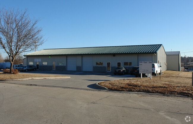
Property Record
309 E 2Nd St, Papillion, NE 68046


Current Lease Availabilities
Property Detail
309 E 2Nd St
Omaha, NE-IA
TAX LOT R3A1A1 26-14-12 (.53 AC)
011301929
Sarpy
Commercialnec
Nebraska
B and X Area of moderate flood hazard, usually the area between the limits of the 100-year and 500-year floods.
r3a1a
2024
0.53 AC
2025
Sarpy East
010617
Omaha/Council Bluffs
6,000 SF
NEARBY LISTINGS FOR SALE OR LEASE
-
-
View all Papillion listings for lease on LoopNet.com
DEMOGRAPHICS near 309 E 2Nd St
1 mile
3 mile
5 mile
2025 Total Population
9,539
67,906
158,403
2030 Population
10,083
72,181
166,793
Pop Growth 2025-2030
+ 5.70%
+ 6.30%
+ 5.30%
Average Age
40
39
38
2025 Total Households
3,534
25,495
61,095
HH Growth 2025-2030
+ 5.94%
+ 6.45%
+ 5.36%
Median Household Inc
$99,711
$102,733
$89,814
Avg Household Size
2.60
2.60
2.50
2025 Avg HH Vehicles
2.00
2.00
2.00
Median Home Value
$277,768
$330,750
$282,389
Median Year Built
1980
1994
1985
Nearby Places
Map Layers
Map Styles
 Street
 Aerial
Transit
 Traffic
 Biking
Places
Listings with unknown addresses are not visible on the map
- Restaurants
- Banks
- Shops
- Fitness
- Groceries
PUBLIC TRANSPORTATION
AIRPORT
Eppley Airfield
Drive
Walk
Distance
Eppley Airfield
29 min
16.1 mi
Nearby Properties
Address
Land Use
TOTAL SIZE
Lot Size
Zoning
Address
Land Use
TOTAL SIZE
Lot Size
Zoning
483,925 SF
42.06 AC
Address
Land Use
TOTAL SIZE
Lot Size
Zoning
28,401 SF
27.31 AC
Address
Land Use
TOTAL SIZE
Lot Size
Zoning
25,204 SF
2.34 AC
R4
Address
Land Use
TOTAL SIZE
Lot Size
Zoning
28,820 SF
16.81 AC
Address
Land Use
TOTAL SIZE
Lot Size
Zoning
599,779 SF
46.87 AC
I1
Address
Land Use
TOTAL SIZE
Lot Size
Zoning
317,277 SF
20.12 AC
Address
Land Use
TOTAL SIZE
Lot Size
Zoning
46,886 SF
19.29 AC
Address
Land Use
TOTAL SIZE
Lot Size
Zoning
28,913 SF
2.04 AC
Address
Land Use
TOTAL SIZE
Lot Size
Zoning
294,672 SF
15.06 AC
Address
Land Use
TOTAL SIZE
Lot Size
Zoning
13,930 SF
1.04 AC
Address
Land Use
TOTAL SIZE
Lot Size
Zoning
271,404 SF
17.51 AC
Address
Land Use
TOTAL SIZE
Lot Size
Zoning
258,637 SF
24.30 AC
Address
Land Use
TOTAL SIZE
Lot Size
Zoning
88,545 SF
9.58 AC
Address
Land Use
TOTAL SIZE
Lot Size
Zoning
2,610 SF
9.96 AC
Address
Land Use
TOTAL SIZE
Lot Size
Zoning
1,356 SF
415.31 AC
Address
Land Use
TOTAL SIZE
Lot Size
Zoning
37,196 SF
13.96 AC
MU
Address
Land Use
TOTAL SIZE
Lot Size
Zoning
18,484 SF
5.47 AC
Address
Land Use
TOTAL SIZE
Lot Size
Zoning
11,244 SF
6.91 AC
Address
Land Use
TOTAL SIZE
Lot Size
Zoning
217,511 SF
25.06 AC
Address
Land Use
TOTAL SIZE
Lot Size
Zoning
149,713 SF
10.46 AC
Address
Land Use
TOTAL SIZE
Lot Size
Zoning
11,889 SF
5.58 AC
Address
Land Use
TOTAL SIZE
Lot Size
Zoning
196,746 SF
10.22 AC
Address
Land Use
TOTAL SIZE
Lot Size
Zoning
96,970 SF
9.68 AC
Address
Land Use
TOTAL SIZE
Lot Size
Zoning
6,472 SF
4.58 AC
Address
Land Use
TOTAL SIZE
Lot Size
Zoning
170,665 SF
10.94 AC
Address
Land Use
TOTAL SIZE
Lot Size
Zoning
130,245 SF
6.93 AC
Address
Land Use
TOTAL SIZE
Lot Size
Zoning
7,448 SF
4.71 AC
Address
Land Use
TOTAL SIZE
Lot Size
Zoning
7,448 SF
2.89 AC
Address
Land Use
TOTAL SIZE
Lot Size
Zoning
200,793 SF
20.66 AC
Address
Land Use
TOTAL SIZE
Lot Size
Zoning
92,567 SF
2.43 AC
The World's #1 Commercial Real Estate Marketplace
Connect with us
© 2026 CoStar Group
The information above has been obtained from sources believed reliable. While we do not doubt its accuracy we have not verified it and make no guarantee, warranty or representation about it. It is your responsibility to independently confirm its accuracy and completeness. Any projections, opinions, assumptions, or estimates used are for example only and do not represent the current or future performance of the property. The value of this transaction to you depends on tax and other factors which should be evaluated by your tax, financial, and legal advisors. You and your advisors should conduct a careful, independent investigation of the property to determine to your satisfaction the suitability of the property for your needs.