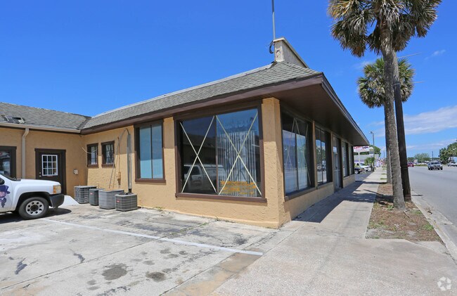
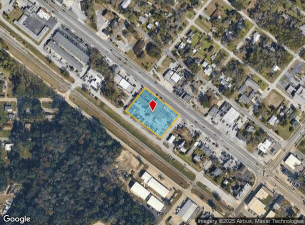
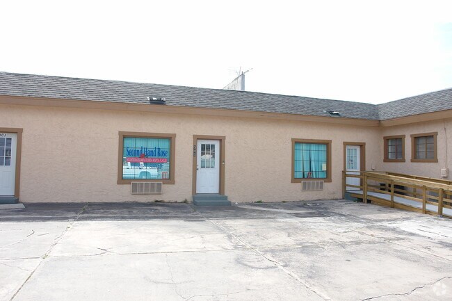
Property Record
309 N State St, Bunnell, FL 32110
NEARBY LISTINGS FOR SALE OR LEASE
Property Detail
309 N State St
Deltona-Daytona Beach-Ormond Beach, FL
Town Of Bunnell
10-12-30-0850-01750-0030
TOWN OF BUNNELL BLOCK 175 LOTS 1 THRU 12 (EX US 1 RW) OR 30 PG 140, OR 44 PG 589 OR 48 PG 611, OR 64 PG 579 PR 86 PG 450, OR 130 PG 257 OR 200 PG 206, OR 256 PG 263 OR 485 PG 1516 (LOCATED IN SECTION 15)256 PGS 263 THRU 269 OR 485 PG 1516 OR 582 PG 1
Commercialnec
Flagler
X
Florida
12035C0209E
3
2024
1.42 AC
2025
Daytona Area
060206
Other Market Areas
52,245 SF
DEMOGRAPHICS near 309 N State St
1 Mile
3 Mile
5 Mile
2024 Total Population
2,321
14,956
46,029
2029 Population
2,794
18,241
56,342
Pop Growth 2024-2029
+ 20.38%
+ 21.96%
+ 22.41%
Average Age
43
45
45
2024 Total Households
882
5,926
18,140
HH Growth 2024-2029
+ 19.61%
+ 21.26%
+ 21.69%
Median Household Inc
$37,916
$60,591
$61,575
Avg Household Size
2.30
2.40
2.50
2024 Avg HH Vehicles
1.00
2.00
2.00
Median Home Value
$217,832
$273,728
$256,353
Median Year Built
1986
2003
2003
Nearby Places
Map Layers
Map Styles
 Street
 Aerial
- Restaurants
- Banks
- Shops
- Fitness
- Groceries
PUBLIC TRANSPORTATION
AIRPORT
Daytona Beach International
DRIVE
WALK
Distance
Daytona Beach International
35 min
26.5 mi
Freight Ports
Jacksonville Port
DRIVE
WALK
Distance
Jacksonville Port
85 min
70.1 mi
Nearby Properties
Address
Land Use
TOTAL SIZE
Lot Size
Zoning
Address
Land Use
TOTAL SIZE
Lot Size
Zoning
320,259 SF
83.19 AC
P
Address
Land Use
TOTAL SIZE
Lot Size
Zoning
280,742 SF
16.06 AC
MPD
Address
Land Use
TOTAL SIZE
Lot Size
Zoning
236,316 SF
61.38 AC
PSP
Address
Land Use
TOTAL SIZE
Lot Size
Zoning
138,991 SF
18.66 AC
P
Address
Land Use
TOTAL SIZE
Lot Size
Zoning
121,173 SF
10 AC
AC
Address
Land Use
TOTAL SIZE
Lot Size
Zoning
64,208 SF
8.41 AC
PSP
Address
Land Use
TOTAL SIZE
Lot Size
Zoning
220,314 SF
17.41 AC
MPD
Address
Land Use
TOTAL SIZE
Lot Size
Zoning
68,684 SF
9.68 AC
MPD
Address
Land Use
TOTAL SIZE
Lot Size
Zoning
89,590 SF
9.90 AC
B-1
Address
Land Use
TOTAL SIZE
Lot Size
Zoning
59,889 SF
0.75 AC
R-3A
Address
Land Use
TOTAL SIZE
Lot Size
Zoning
67,008 SF
5.34 AC
B-1
Address
Land Use
TOTAL SIZE
Lot Size
Zoning
32,679 SF
101.42 AC
L-1
Address
Land Use
TOTAL SIZE
Lot Size
Zoning
112,200 SF
49.38 AC
L-1
Address
Land Use
TOTAL SIZE
Lot Size
Zoning
163,592 SF
10 AC
IND-1
Address
Land Use
TOTAL SIZE
Lot Size
Zoning
41,710 SF
11.97 AC
L-1
Address
Land Use
TOTAL SIZE
Lot Size
Zoning
4,158 SF
3.73 AC
P
Address
Land Use
TOTAL SIZE
Lot Size
Zoning
43,990 SF
4.84 AC
P
Address
Land Use
TOTAL SIZE
Lot Size
Zoning
18,852 SF
3.23 AC
COM-2
Address
Land Use
TOTAL SIZE
Lot Size
Zoning
38,420 SF
4.83 AC
C-2(F)
Address
Land Use
TOTAL SIZE
Lot Size
Zoning
60,582 SF
2.20 AC
MPD
Address
Land Use
TOTAL SIZE
Lot Size
Zoning
76,339 SF
4 AC
B-1
Address
Land Use
TOTAL SIZE
Lot Size
Zoning
10,310 SF
1.54 AC
Address
Land Use
TOTAL SIZE
Lot Size
Zoning
66,485 SF
28.20 AC
Address
Land Use
TOTAL SIZE
Lot Size
Zoning
17,901 SF
1.72 AC
COM-2
Address
Land Use
TOTAL SIZE
Lot Size
Zoning
41,293 SF
4.92 AC
B-1
Address
Land Use
TOTAL SIZE
Lot Size
Zoning
65,787 SF
11.88 AC
B-1
Address
Land Use
TOTAL SIZE
Lot Size
Zoning
55,468 SF
7.25 AC
O-1
Address
Land Use
TOTAL SIZE
Lot Size
Zoning
49,785 SF
1.35 AC
B-2
Address
Land Use
TOTAL SIZE
Lot Size
Zoning
4,539 SF
1.16 AC
COM-2
The World's #1 Commercial Real Estate Marketplace
Connect with us
© 2025 CoStar Group
The information above has been obtained from sources believed reliable. While we do not doubt its accuracy we have not verified it and make no guarantee, warranty or representation about it. It is your responsibility to independently confirm its accuracy and completeness. Any projections, opinions, assumptions, or estimates used are for example only and do not represent the current or future performance of the property. The value of this transaction to you depends on tax and other factors which should be evaluated by your tax, financial, and legal advisors. You and your advisors should conduct a careful, independent investigation of the property to determine to your satisfaction the suitability of the property for your needs.