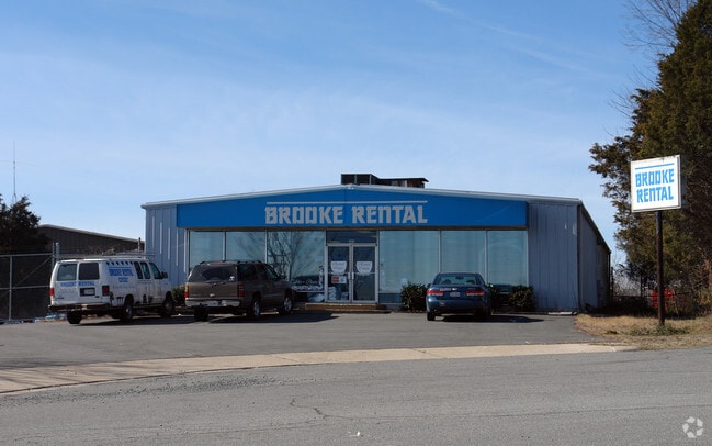
Property Record
309 Parker Ct Se, Leesburg, VA 20175


Current Lease Availabilities
NEARBY LISTINGS FOR SALE OR LEASE
Property Detail
309 Parker Ct Se
Washington-Arlington-Alexandria, DC-VA-MD-WV
Parker Sub Div
231-10-1794
PARKER SUB DIV LOT 38 200611300099543
Storebuilding
Loudoun
X
Virginia
51107C0231E
38
2025
0.46 AC
2025
Leesburg/West Loudoun
610505
Washington, DC
4,000 SF
DEMOGRAPHICS near 309 Parker Ct Se
1 Mile
3 Mile
5 Mile
2024 Total Population
18,850
58,230
89,701
2029 Population
20,339
62,781
96,638
Pop Growth 2024-2029
+ 7.90%
+ 7.82%
+ 7.73%
Average Age
36
37
38
2024 Total Households
6,522
19,134
29,754
HH Growth 2024-2029
+ 7.71%
+ 7.89%
+ 7.88%
Median Household Inc
$90,990
$129,004
$149,086
Avg Household Size
2.80
3.00
2.90
2024 Avg HH Vehicles
2.00
2.00
2.00
Median Home Value
$469,679
$621,007
$682,075
Median Year Built
1985
1994
1999
Nearby Places
Map Layers
Map Styles
 Street
 Aerial
- Restaurants
- Banks
- Shops
- Fitness
- Groceries
PUBLIC TRANSPORTATION
AIRPORT
Washington Dulles International
DRIVE
WALK
Distance
Washington Dulles International
29 min
16.3 mi
Ronald Reagan Washington Ntl
DRIVE
WALK
Distance
Ronald Reagan Washington Ntl
59 min
38.0 mi
Nearby Properties
Address
Land Use
TOTAL SIZE
Lot Size
Zoning
Address
Land Use
TOTAL SIZE
Lot Size
Zoning
793,474 SF
311.38 AC
PDIP
Address
Land Use
TOTAL SIZE
Lot Size
Zoning
413,297 SF
21.77 AC
LB:MC
Address
Land Use
TOTAL SIZE
Lot Size
Zoning
485,476 SF
54.14 AC
LB:B3
Address
Land Use
TOTAL SIZE
Lot Size
Zoning
553,617 SF
592.60 AC
PDSA
Address
Land Use
TOTAL SIZE
Lot Size
Zoning
420,787 SF
LB:B4
Address
Land Use
TOTAL SIZE
Lot Size
Zoning
37.61 AC
IP
Address
Land Use
TOTAL SIZE
Lot Size
Zoning
300,570 SF
OP
Address
Land Use
TOTAL SIZE
Lot Size
Zoning
331,227 SF
21.75 AC
LB:PRN
Address
Land Use
TOTAL SIZE
Lot Size
Zoning
279,428 SF
132.70 AC
LB:RE
Address
Land Use
TOTAL SIZE
Lot Size
Zoning
248,513 SF
15.77 AC
LB:R22
Address
Land Use
TOTAL SIZE
Lot Size
Zoning
323,043 SF
27.90 AC
LB:B3
Address
Land Use
TOTAL SIZE
Lot Size
Zoning
228,886 SF
29.43 AC
LB:B3
Address
Land Use
TOTAL SIZE
Lot Size
Zoning
388,150 SF
PDIP
Address
Land Use
TOTAL SIZE
Lot Size
Zoning
261,445 SF
17.95 AC
LB:I1
Address
Land Use
TOTAL SIZE
Lot Size
Zoning
242,603 SF
67.48 AC
LB:RE
Address
Land Use
TOTAL SIZE
Lot Size
Zoning
245,886 SF
52.32 AC
LB:RE
Address
Land Use
TOTAL SIZE
Lot Size
Zoning
158,560 SF
2.44 AC
LB:GC
Address
Land Use
TOTAL SIZE
Lot Size
Zoning
258,867 SF
12.57 AC
LB:R22
Address
Land Use
TOTAL SIZE
Lot Size
Zoning
131,283 SF
27.84 AC
LB:B3
Address
Land Use
TOTAL SIZE
Lot Size
Zoning
148,448 SF
9.71 AC
LB:PEC
Address
Land Use
TOTAL SIZE
Lot Size
Zoning
190,454 SF
31.50 AC
LB:R4
Address
Land Use
TOTAL SIZE
Lot Size
Zoning
83,169 SF
138.05 AC
LB:R1
Address
Land Use
TOTAL SIZE
Lot Size
Zoning
196,665 SF
18.96 AC
LB:PRN
Address
Land Use
TOTAL SIZE
Lot Size
Zoning
72,408 SF
197.99 AC
AR1
Address
Land Use
TOTAL SIZE
Lot Size
Zoning
156,958 SF
17.63 AC
LB:PRC
Address
Land Use
TOTAL SIZE
Lot Size
Zoning
18.85 AC
PDH4
Address
Land Use
TOTAL SIZE
Lot Size
Zoning
92,412 SF
18.27 AC
LB:I1
Address
Land Use
TOTAL SIZE
Lot Size
Zoning
79,388 SF
1.86 AC
LB:GC
Address
Land Use
TOTAL SIZE
Lot Size
Zoning
201,306 SF
9.94 AC
LB:R22
Address
Land Use
TOTAL SIZE
Lot Size
Zoning
90,756 SF
7.91 AC
LB:PRN
The World's #1 Commercial Real Estate Marketplace
Connect with us
© 2026 CoStar Group
The information above has been obtained from sources believed reliable. While we do not doubt its accuracy we have not verified it and make no guarantee, warranty or representation about it. It is your responsibility to independently confirm its accuracy and completeness. Any projections, opinions, assumptions, or estimates used are for example only and do not represent the current or future performance of the property. The value of this transaction to you depends on tax and other factors which should be evaluated by your tax, financial, and legal advisors. You and your advisors should conduct a careful, independent investigation of the property to determine to your satisfaction the suitability of the property for your needs.