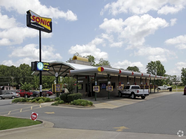
Property Record
3090 Bill Foster Memorial Hwy, Cabot, AR 72023

NEARBY LISTINGS FOR SALE OR LEASE
Property Detail
3090 Bill Foster Memorial Hwy
Little Rock-North Little Rock-Conway, AR
Bill Foster Addition
001-12378-002
PT NW SE (PT TR 8 & 7) DEER ACRES SURVEY
Restaurantbuilding
Lonoke
AE
Arkansas
05085C0083D
1
2023
0.84 AC
2025
Lonoke County
020204
Little Rock/N Little Rock
1,893 SF
DEMOGRAPHICS near 3090 Bill Foster Memorial Hwy
1 Mile
3 Mile
5 Mile
2024 Total Population
994
12,744
35,449
2029 Population
1,033
13,146
36,393
Pop Growth 2024-2029
+ 3.92%
+ 3.15%
+ 2.66%
Average Age
37
38
39
2024 Total Households
410
5,041
13,725
HH Growth 2024-2029
+ 3.90%
+ 3.07%
+ 2.61%
Median Household Inc
$59,726
$54,034
$60,676
Avg Household Size
2.40
2.50
2.50
2024 Avg HH Vehicles
2.00
2.00
2.00
Median Home Value
$160,203
$151,849
$168,919
Median Year Built
1996
1995
1994
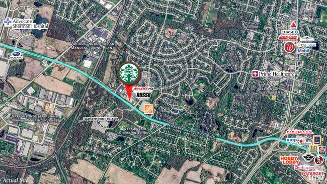
Nearby Places
Map Layers
Map Styles
 Street
 Aerial
- Restaurants
- Banks
- Shops
- Fitness
- Groceries
PUBLIC TRANSPORTATION
AIRPORT
Bill and Hillary Clinton Ntl/Adams Field
DRIVE
WALK
Distance
Bill and Hillary Clinton Ntl/Adams Field
27 min
22.6 mi
Freight Ports
Port of Shreveport
DRIVE
WALK
Distance
Port of Shreveport
273 min
253.6 mi
SALE & LEASE HISTORY
LISTING DATE
SALE/LEASE

Mar 17, 2025
For Sale
Nearby Properties
Address
Land Use
TOTAL SIZE
Lot Size
Zoning
Address
Land Use
TOTAL SIZE
Lot Size
Zoning
150,958 SF
10.19 AC
Address
Land Use
TOTAL SIZE
Lot Size
Zoning
226,799 SF
21.73 AC
Address
Land Use
TOTAL SIZE
Lot Size
Zoning
199,090 SF
9.82 AC
Address
Land Use
TOTAL SIZE
Lot Size
Zoning
143,892 SF
8.65 AC
Address
Land Use
TOTAL SIZE
Lot Size
Zoning
134,045 SF
12.15 AC
Address
Land Use
TOTAL SIZE
Lot Size
Zoning
141,490 SF
9.97 AC
Address
Land Use
TOTAL SIZE
Lot Size
Zoning
184,011 SF
15 AC
Address
Land Use
TOTAL SIZE
Lot Size
Zoning
25,956 SF
3.22 AC
Address
Land Use
TOTAL SIZE
Lot Size
Zoning
62,250 SF
8.59 AC
Address
Land Use
TOTAL SIZE
Lot Size
Zoning
13,302 SF
0.71 AC
Address
Land Use
TOTAL SIZE
Lot Size
Zoning
50,550 SF
8.98 AC
Address
Land Use
TOTAL SIZE
Lot Size
Zoning
60,322 SF
10 AC
Address
Land Use
TOTAL SIZE
Lot Size
Zoning
104,795 SF
12.07 AC
Address
Land Use
TOTAL SIZE
Lot Size
Zoning
51,992 SF
2.82 AC
Address
Land Use
TOTAL SIZE
Lot Size
Zoning
45,172 SF
4.35 AC
Address
Land Use
TOTAL SIZE
Lot Size
Zoning
67,672 SF
5.23 AC
Address
Land Use
TOTAL SIZE
Lot Size
Zoning
10,408 SF
6.25 AC
Address
Land Use
TOTAL SIZE
Lot Size
Zoning
91,224 SF
8.39 AC
Address
Land Use
TOTAL SIZE
Lot Size
Zoning
15,600 SF
3 AC
Address
Land Use
TOTAL SIZE
Lot Size
Zoning
9,750 SF
1.62 AC
Address
Land Use
TOTAL SIZE
Lot Size
Zoning
28,943 SF
3.39 AC
Address
Land Use
TOTAL SIZE
Lot Size
Zoning
18,550 SF
11.37 AC
Address
Land Use
TOTAL SIZE
Lot Size
Zoning
29,416 SF
3.15 AC
Address
Land Use
TOTAL SIZE
Lot Size
Zoning
99,270 SF
1.38 AC
Address
Land Use
TOTAL SIZE
Lot Size
Zoning
9,036 SF
4.68 AC
Address
Land Use
TOTAL SIZE
Lot Size
Zoning
1,863 SF
26.05 AC
Address
Land Use
TOTAL SIZE
Lot Size
Zoning
6,270 SF
11.51 AC
Address
Land Use
TOTAL SIZE
Lot Size
Zoning
8,450 SF
0.62 AC
Address
Land Use
TOTAL SIZE
Lot Size
Zoning
19,967 SF
2.06 AC
Address
Land Use
TOTAL SIZE
Lot Size
Zoning
46,936 SF
7.70 AC
The World's #1 Commercial Real Estate Marketplace
Connect with us
© 2025 CoStar Group
The information above has been obtained from sources believed reliable. While we do not doubt its accuracy we have not verified it and make no guarantee, warranty or representation about it. It is your responsibility to independently confirm its accuracy and completeness. Any projections, opinions, assumptions, or estimates used are for example only and do not represent the current or future performance of the property. The value of this transaction to you depends on tax and other factors which should be evaluated by your tax, financial, and legal advisors. You and your advisors should conduct a careful, independent investigation of the property to determine to your satisfaction the suitability of the property for your needs.