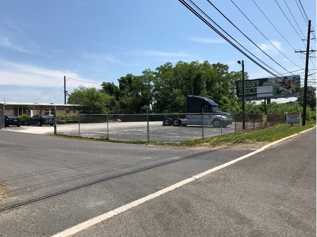
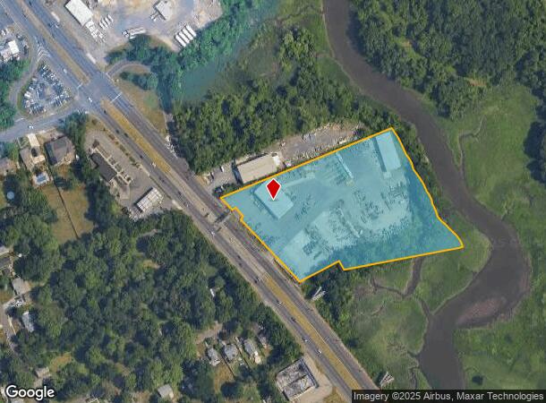
Property Record
3090 Route 73 N, Maple Shade, NJ 08052

NEARBY LISTINGS FOR SALE OR LEASE
Property Detail
3090 Route 73 N
Philadelphia-Camden-Wilmington, PA-NJ-DE-MD
INCL BLK 7.03 LOTS 11.01 12 & 12.01
19-00007-03-00011-01
Burlington
Warehouse
New Jersey
AE
11.1
34005C0207F
5.40 AC
2024
North Burlington County
2025
Philadelphia
700401
DEMOGRAPHICS near 3090 Route 73 N
1 Mile
3 Mile
5 Mile
2024 Total Population
6,957
89,307
274,163
2029 Population
7,090
90,518
273,212
Pop Growth 2024-2029
+ 1.91%
+ 1.36%
(0.35%)
Average Age
43
41
39
2024 Total Households
2,662
34,942
102,998
HH Growth 2024-2029
+ 1.80%
+ 1.45%
(0.30%)
Median Household Inc
$86,988
$94,469
$80,460
Avg Household Size
2.50
2.50
2.60
2024 Avg HH Vehicles
2.00
2.00
2.00
Median Home Value
$247,544
$265,996
$245,512
Median Year Built
1960
1964
1958
Nearby Places
Map Layers
Map Styles
 Street
 Aerial
- Restaurants
- Banks
- Shops
- Fitness
- Groceries
PUBLIC TRANSPORTATION
COMMUTER RAIL
Pennsauken Transit Center (Atlantic City Rail Line - NJ TRANSIT RAIL)
DRIVE
WALK
Distance
Pennsauken Transit Center (Atlantic City Rail Line - NJ TRANSIT RAIL)
6 min
3.6 mi
Cherry Hill (Atlantic City Line - NJ Transit Commuter Rail (NJ Transit))
DRIVE
WALK
Distance
Cherry Hill (Atlantic City Line - NJ Transit Commuter Rail (NJ Transit))
12 min
5.9 mi
AIRPORT
Philadelphia International
DRIVE
WALK
Distance
Philadelphia International
31 min
18.8 mi
Trenton Mercer
DRIVE
WALK
Distance
Trenton Mercer
45 min
32.6 mi
Freight Ports
Port of Philadelphia
DRIVE
WALK
Distance
Port of Philadelphia
10 min
6.4 mi
SALE & LEASE HISTORY
LISTING DATE
SALE/LEASE

Jan 13, 2017
For Lease
Nearby Properties
Address
Land Use
TOTAL SIZE
Lot Size
Zoning
Address
Land Use
TOTAL SIZE
Lot Size
Zoning
66.02 AC
Address
Land Use
TOTAL SIZE
Lot Size
Zoning
Address
Land Use
TOTAL SIZE
Lot Size
Zoning
90.41 AC
Address
Land Use
TOTAL SIZE
Lot Size
Zoning
20.13 AC
Address
Land Use
TOTAL SIZE
Lot Size
Zoning
72.46 AC
Address
Land Use
TOTAL SIZE
Lot Size
Zoning
38.76 AC
Address
Land Use
TOTAL SIZE
Lot Size
Zoning
54.54 AC
Address
Land Use
TOTAL SIZE
Lot Size
Zoning
1 SF
42.23 AC
Address
Land Use
TOTAL SIZE
Lot Size
Zoning
50.73 AC
C73A
Address
Land Use
TOTAL SIZE
Lot Size
Zoning
37.60 AC
Address
Land Use
TOTAL SIZE
Lot Size
Zoning
Address
Land Use
TOTAL SIZE
Lot Size
Zoning
12.80 AC
R20
Address
Land Use
TOTAL SIZE
Lot Size
Zoning
6.25 AC
Address
Land Use
TOTAL SIZE
Lot Size
Zoning
43.20 AC
Address
Land Use
TOTAL SIZE
Lot Size
Zoning
Address
Land Use
TOTAL SIZE
Lot Size
Zoning
5.35 AC
Address
Land Use
TOTAL SIZE
Lot Size
Zoning
28.96 AC
Address
Land Use
TOTAL SIZE
Lot Size
Zoning
Address
Land Use
TOTAL SIZE
Lot Size
Zoning
82.32 AC
Address
Land Use
TOTAL SIZE
Lot Size
Zoning
3.59 AC
Address
Land Use
TOTAL SIZE
Lot Size
Zoning
22.45 AC
MD
Address
Land Use
TOTAL SIZE
Lot Size
Zoning
15.10 AC
Address
Land Use
TOTAL SIZE
Lot Size
Zoning
39.53 AC
Address
Land Use
TOTAL SIZE
Lot Size
Zoning
26.17 AC
Address
Land Use
TOTAL SIZE
Lot Size
Zoning
27.77 AC
Address
Land Use
TOTAL SIZE
Lot Size
Zoning
150.59 AC
Address
Land Use
TOTAL SIZE
Lot Size
Zoning
25.37 AC
Address
Land Use
TOTAL SIZE
Lot Size
Zoning
26.25 AC
Address
Land Use
TOTAL SIZE
Lot Size
Zoning
12.19 AC
Address
Land Use
TOTAL SIZE
Lot Size
Zoning
37.21 AC
The World's #1 Commercial Real Estate Marketplace
Connect with us
© 2025 CoStar Group
The information above has been obtained from sources believed reliable. While we do not doubt its accuracy we have not verified it and make no guarantee, warranty or representation about it. It is your responsibility to independently confirm its accuracy and completeness. Any projections, opinions, assumptions, or estimates used are for example only and do not represent the current or future performance of the property. The value of this transaction to you depends on tax and other factors which should be evaluated by your tax, financial, and legal advisors. You and your advisors should conduct a careful, independent investigation of the property to determine to your satisfaction the suitability of the property for your needs.