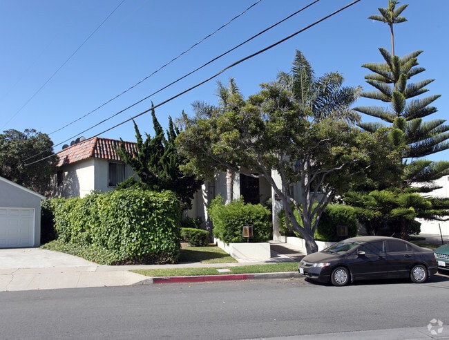
Property Record
3098 Channel Dr, Ventura, CA 93003


Property Detail
3098 Channel Dr
075-0-350-045
LOT: 4 REF: 001PM 038
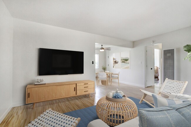
Apartment
Ventura
R3-2
California
B and X Area of moderate flood hazard, usually the area between the limits of the 100-year and 500-year floods.
4
2024
1.13 AC
2025
Ventura
002800
Los Angeles
24,904 SF
Oxnard-Thousand Oaks-Ventura, CA
NEARBY LISTINGS FOR SALE OR LEASE
DEMOGRAPHICS near 3098 Channel Dr
1 mile
3 mile
5 mile
2025 Total Population
13,539
56,596
134,743
2030 Population
13,626
56,848
134,738
Pop Growth 2025-2030
+ 0.64%
+ 0.45%
0.00%
Average Age
43
43
42
2025 Total Households
5,634
23,301
49,601
HH Growth 2025-2030
+ 0.76%
+ 0.46%
(0.01%)
Median Household Inc
$104,840
$97,081
$104,244
Avg Household Size
2.30
2.30
2.60
2025 Avg HH Vehicles
2.00
2.00
2.00
Median Home Value
$866,621
$856,105
$799,738
Median Year Built
1961
1967
1974
Nearby Places
Map Layers
Map Styles
 Street
 Aerial
Layers
 Traffic
 Biking
Places
Listings with unknown addresses are not visible on the map
- Restaurants
- Banks
- Shops
- Fitness
- Groceries
PUBLIC TRANSPORTATION
COMMUTER RAIL
Ventura Amtrak (Pacific Surfliner - Amtrak)
Drive
Walk
Distance
Ventura Amtrak (Pacific Surfliner - Amtrak)
10 min
3.8 mi
East Ventura Metrolink Station (Metrolink Ventura County Line - Metrolink Trains)
Drive
Walk
Distance
East Ventura Metrolink Station (Metrolink Ventura County Line - Metrolink Trains)
8 min
3.9 mi
Freight Ports
The Port of Hueneme
Drive
Walk
Distance
The Port of Hueneme
22 min
11.6 mi
SALE & LEASE HISTORY
LISTING DATE
SALE/LEASE

Sep 13, 2021
For Sale
Jun 24, 2020
For Sale
Nearby Properties
Address
Land Use
TOTAL SIZE
Lot Size
Zoning
Address
Land Use
TOTAL SIZE
Lot Size
Zoning
1.99 AC
Address
Land Use
TOTAL SIZE
Lot Size
Zoning
4.19 AC
H
Address
Land Use
TOTAL SIZE
Lot Size
Zoning
43,284 SF
14.34 AC
RPD28
Address
Land Use
TOTAL SIZE
Lot Size
Zoning
195,798 SF
15.40 AC
RPD15
Address
Land Use
TOTAL SIZE
Lot Size
Zoning
233,168 SF
13.94 AC
RPD-
Address
Land Use
TOTAL SIZE
Lot Size
Zoning
176,598 SF
9.22 AC
Address
Land Use
TOTAL SIZE
Lot Size
Zoning
Address
Land Use
TOTAL SIZE
Lot Size
Zoning
49,296 SF
11.08 AC
Address
Land Use
TOTAL SIZE
Lot Size
Zoning
7,280 SF
5.38 AC
C-T-O
Address
Land Use
TOTAL SIZE
Lot Size
Zoning
3.01 AC
Address
Land Use
TOTAL SIZE
Lot Size
Zoning
40,110 SF
8.04 AC
MPD
Address
Land Use
TOTAL SIZE
Lot Size
Zoning
6.81 AC
C-T-O
Address
Land Use
TOTAL SIZE
Lot Size
Zoning
2.89 AC
C-T-O
Address
Land Use
TOTAL SIZE
Lot Size
Zoning
89,643 SF
14.27 AC
Address
Land Use
TOTAL SIZE
Lot Size
Zoning
13,530 SF
10.85 AC
Address
Land Use
TOTAL SIZE
Lot Size
Zoning
25,401 SF
2.74 AC
C1AD
Address
Land Use
TOTAL SIZE
Lot Size
Zoning
81,671 SF
3.54 AC
Address
Land Use
TOTAL SIZE
Lot Size
Zoning
111,421 SF
3.80 AC
Address
Land Use
TOTAL SIZE
Lot Size
Zoning
107,360 SF
5.96 AC
RPD15
Address
Land Use
TOTAL SIZE
Lot Size
Zoning
36,186 SF
12.16 AC
Address
Land Use
TOTAL SIZE
Lot Size
Zoning
73,272 SF
6.05 AC
C1AD
Address
Land Use
TOTAL SIZE
Lot Size
Zoning
58,841 SF
6.74 AC
CPD
Address
Land Use
TOTAL SIZE
Lot Size
Zoning
76,449 SF
6.88 AC
CPD
Address
Land Use
TOTAL SIZE
Lot Size
Zoning
65,192 SF
3.20 AC
RPD-
Address
Land Use
TOTAL SIZE
Lot Size
Zoning
3.26 AC
PO
Address
Land Use
TOTAL SIZE
Lot Size
Zoning
96,277 SF
7.72 AC
Address
Land Use
TOTAL SIZE
Lot Size
Zoning
68,148 SF
3.75 AC
P-O
Address
Land Use
TOTAL SIZE
Lot Size
Zoning
Address
Land Use
TOTAL SIZE
Lot Size
Zoning
51,078 SF
1.73 AC
The World's #1 Commercial Real Estate Marketplace
Connect with us
© 2026 CoStar Group
The information above has been obtained from sources believed reliable. While we do not doubt its accuracy we have not verified it and make no guarantee, warranty or representation about it. It is your responsibility to independently confirm its accuracy and completeness. Any projections, opinions, assumptions, or estimates used are for example only and do not represent the current or future performance of the property. The value of this transaction to you depends on tax and other factors which should be evaluated by your tax, financial, and legal advisors. You and your advisors should conduct a careful, independent investigation of the property to determine to your satisfaction the suitability of the property for your needs.