Property Record
3122 Highway 154 Rd, Newnan, GA 30265
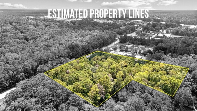
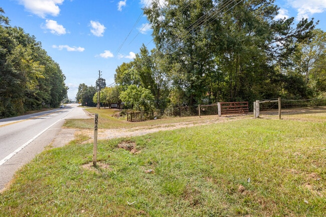
This Property Is For Sale
NEARBY LISTINGS FOR SALE OR LEASE
Property Detail
3122 Highway 154 Rd
121-6039-007A
H/2.81 AC., LL39/6LD HWY 154
Sfr
Coweta
X
Georgia
13077C0170D
39
2025
1.24 AC
2025
Fayette/Coweta County
170404
Atlanta
2,072 SF
Atlanta-Sandy Springs-Roswell, GA
DEMOGRAPHICS near 3122 Highway 154 Rd
1 Mile
3 Mile
5 Mile
2024 Total Population
2,454
20,601
65,419
2029 Population
2,707
22,837
72,016
Pop Growth 2024-2029
+ 10.31%
+ 10.85%
+ 10.08%
Average Age
43
42
41
2024 Total Households
901
7,357
24,139
HH Growth 2024-2029
+ 10.43%
+ 10.96%
+ 10.13%
Median Household Inc
$97,002
$108,992
$101,050
Avg Household Size
2.70
2.80
2.70
2024 Avg HH Vehicles
2.00
2.00
2.00
Median Home Value
$288,297
$280,876
$300,802
Median Year Built
1994
1995
1998
Nearby Places
- Restaurants
- Banks
- Shops
- Fitness
- Groceries
PUBLIC TRANSPORTATION
AIRPORT
Hartsfield - Jackson Atlanta International
DRIVE
WALK
Distance
Hartsfield - Jackson Atlanta International
35 min
26.5 mi
Freight Ports
Georgia Ports - Savannah
DRIVE
WALK
Distance
Georgia Ports - Savannah
291 min
249.0 mi
Nearby Properties
Address
Land Use
TOTAL SIZE
Lot Size
Zoning
Address
Land Use
TOTAL SIZE
Lot Size
Zoning
1,001,000 SF
118.56 AC
R1
Address
Land Use
TOTAL SIZE
Lot Size
Zoning
1,079,000 SF
73.44 AC
M
Address
Land Use
TOTAL SIZE
Lot Size
Zoning
1,206,927 SF
109.06 AC
R1
Address
Land Use
TOTAL SIZE
Lot Size
Zoning
1,206,927 SF
109.06 AC
R1
Address
Land Use
TOTAL SIZE
Lot Size
Zoning
770,898 SF
215.23 AC
M
Address
Land Use
TOTAL SIZE
Lot Size
Zoning
76,445 SF
25.12 AC
R1
Address
Land Use
TOTAL SIZE
Lot Size
Zoning
457,922 SF
45.16 AC
R1
Address
Land Use
TOTAL SIZE
Lot Size
Zoning
102,007 SF
18.92 AC
002
Address
Land Use
TOTAL SIZE
Lot Size
Zoning
215,344 SF
28.12 AC
R1
Address
Land Use
TOTAL SIZE
Lot Size
Zoning
299,520 SF
32.45 AC
R1
Address
Land Use
TOTAL SIZE
Lot Size
Zoning
117,354 SF
48.81 AC
ND
Address
Land Use
TOTAL SIZE
Lot Size
Zoning
134,417 SF
13.01 AC
R1
Address
Land Use
TOTAL SIZE
Lot Size
Zoning
216,250 SF
20.12 AC
R1
Address
Land Use
TOTAL SIZE
Lot Size
Zoning
108,138 SF
6.36 AC
002
Address
Land Use
TOTAL SIZE
Lot Size
Zoning
71,888 SF
23.48 AC
R1
Address
Land Use
TOTAL SIZE
Lot Size
Zoning
70,162 SF
12.32 AC
001
Address
Land Use
TOTAL SIZE
Lot Size
Zoning
47,598 SF
4.29 AC
C
Address
Land Use
TOTAL SIZE
Lot Size
Zoning
121,290 SF
11.74 AC
R1
Address
Land Use
TOTAL SIZE
Lot Size
Zoning
186,249 SF
17.99 AC
R1
Address
Land Use
TOTAL SIZE
Lot Size
Zoning
48,000 SF
4.65 AC
M
Address
Land Use
TOTAL SIZE
Lot Size
Zoning
63,876 SF
9.58 AC
ND
Address
Land Use
TOTAL SIZE
Lot Size
Zoning
186,695 SF
29.47 AC
R1
Address
Land Use
TOTAL SIZE
Lot Size
Zoning
80,630 SF
1.25 AC
002
Address
Land Use
TOTAL SIZE
Lot Size
Zoning
112,650 SF
5.70 AC
002
Address
Land Use
TOTAL SIZE
Lot Size
Zoning
53,968 SF
3.33 AC
M
Address
Land Use
TOTAL SIZE
Lot Size
Zoning
90,474 SF
12.56 AC
C
Address
Land Use
TOTAL SIZE
Lot Size
Zoning
117,635 SF
20 AC
001
Address
Land Use
TOTAL SIZE
Lot Size
Zoning
28,753 SF
4.83 AC
R1
Address
Land Use
TOTAL SIZE
Lot Size
Zoning
25,372 SF
2.27 AC
001
Address
Land Use
TOTAL SIZE
Lot Size
Zoning
90,615 SF
11.35 AC
ND
The World's #1 Commercial Real Estate Marketplace
Connect with us
© 2025 CoStar Group
The information above has been obtained from sources believed reliable. While we do not doubt its accuracy we have not verified it and make no guarantee, warranty or representation about it. It is your responsibility to independently confirm its accuracy and completeness. Any projections, opinions, assumptions, or estimates used are for example only and do not represent the current or future performance of the property. The value of this transaction to you depends on tax and other factors which should be evaluated by your tax, financial, and legal advisors. You and your advisors should conduct a careful, independent investigation of the property to determine to your satisfaction the suitability of the property for your needs.