Property Record
30A Cape Rd, Mendon, MA 01756


Property Detail
30A Cape Rd
Storebuilding
Worcester
C/I
Massachusetts
B and X Area of moderate flood hazard, usually the area between the limits of the 100-year and 500-year floods.
4 AC
2025
Outlying Worcester
2025
Boston
746100
Worcester, MA
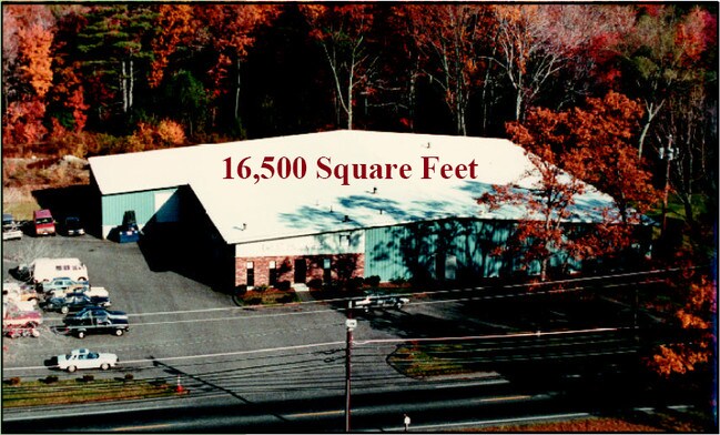
16,380 SF
MEND-000014-000114-000030-000001
NEARBY LISTINGS FOR SALE OR LEASE
DEMOGRAPHICS near 30A Cape Rd
1 mile
3 mile
5 mile
2025 Total Population
1,314
24,106
75,506
2030 Population
1,349
24,898
77,461
Pop Growth 2025-2030
+ 2.66%
+ 3.29%
+ 2.59%
Average Age
42
42
42
2025 Total Households
465
9,188
28,369
HH Growth 2025-2030
+ 2.80%
+ 3.46%
+ 2.69%
Median Household Inc
$152,472
$105,769
$115,975
Avg Household Size
2.80
2.60
2.60
2025 Avg HH Vehicles
2.00
2.00
2.00
Median Home Value
$652,027
$492,071
$518,762
Median Year Built
1984
1981
1976
Nearby Places
Map Layers
Map Styles
 Street
 Aerial
Transit
 Traffic
 Biking
Places
Listings with unknown addresses are not visible on the map
- Restaurants
- Banks
- Shops
- Fitness
- Groceries
PUBLIC TRANSPORTATION
COMMUTER RAIL
Forge Park/Route 495 (Franklin Line - Massachusetts Bay Transportation Authority Commuter Rail (Purple Line))
Drive
Walk
Distance
Forge Park/Route 495 (Franklin Line - Massachusetts Bay Transportation Authority Commuter Rail (Purple Line))
10 min
4.7 mi
Franklin (Franklin Line - Massachusetts Bay Transportation Authority Commuter Rail (Purple Line))
Drive
Walk
Distance
Franklin (Franklin Line - Massachusetts Bay Transportation Authority Commuter Rail (Purple Line))
12 min
6.5 mi
AIRPORT
Worcester Regional
Drive
Walk
Distance
Worcester Regional
51 min
28.8 mi
Rhode Island Tf Green International
Drive
Walk
Distance
Rhode Island Tf Green International
48 min
30.6 mi
General Edward Lawrence Logan International
Drive
Walk
Distance
General Edward Lawrence Logan International
62 min
45.1 mi
Freight Ports
Port of Davisville, RI
Drive
Walk
Distance
Port of Davisville, RI
60 min
42.5 mi
SALE & LEASE HISTORY
LISTING DATE
SALE/LEASE

Oct 07, 2019
For Sale
Nearby Properties
Address
Land Use
TOTAL SIZE
Lot Size
Zoning
Address
Land Use
TOTAL SIZE
Lot Size
Zoning
20.97 AC
CRPC
Address
Land Use
TOTAL SIZE
Lot Size
Zoning
322,615 SF
17.33 AC
SUBN
Address
Land Use
TOTAL SIZE
Lot Size
Zoning
14.82 AC
AGR
Address
Land Use
TOTAL SIZE
Lot Size
Zoning
345,000 SF
60.44 AC
BUS1
Address
Land Use
TOTAL SIZE
Lot Size
Zoning
204,879 SF
12.44 AC
OR
Address
Land Use
TOTAL SIZE
Lot Size
Zoning
616,875 SF
141 AC
LI
Address
Land Use
TOTAL SIZE
Lot Size
Zoning
183,839 SF
39.29 AC
IND
Address
Land Use
TOTAL SIZE
Lot Size
Zoning
300,000 SF
64.63 AC
IND
Address
Land Use
TOTAL SIZE
Lot Size
Zoning
231,817 SF
35.01 AC
IND
Address
Land Use
TOTAL SIZE
Lot Size
Zoning
253,656 SF
44.84 AC
IND
Address
Land Use
TOTAL SIZE
Lot Size
Zoning
24.81 AC
IB
Address
Land Use
TOTAL SIZE
Lot Size
Zoning
238,602 SF
109.37 AC
Address
Land Use
TOTAL SIZE
Lot Size
Zoning
238,975 SF
33.82 AC
IND
Address
Land Use
TOTAL SIZE
Lot Size
Zoning
451,000 SF
90.70 AC
IND
Address
Land Use
TOTAL SIZE
Lot Size
Zoning
75,140 SF
39.40 AC
Address
Land Use
TOTAL SIZE
Lot Size
Zoning
347,012 SF
29.23 AC
IB
Address
Land Use
TOTAL SIZE
Lot Size
Zoning
208,826 SF
18.96 AC
IND
Address
Land Use
TOTAL SIZE
Lot Size
Zoning
96,433 SF
5.40 AC
RB
Address
Land Use
TOTAL SIZE
Lot Size
Zoning
203,792 SF
27.93 AC
IND
Address
Land Use
TOTAL SIZE
Lot Size
Zoning
120,327 SF
28.75 AC
BUS2
Address
Land Use
TOTAL SIZE
Lot Size
Zoning
7.36 AC
RA
Address
Land Use
TOTAL SIZE
Lot Size
Zoning
19.14 AC
IB
Address
Land Use
TOTAL SIZE
Lot Size
Zoning
127,500 SF
22.01 AC
IND
Address
Land Use
TOTAL SIZE
Lot Size
Zoning
113,044 SF
71.52 AC
B
Address
Land Use
TOTAL SIZE
Lot Size
Zoning
165,132 SF
24.49 AC
IN3
Address
Land Use
TOTAL SIZE
Lot Size
Zoning
106.49 AC
IB
Address
Land Use
TOTAL SIZE
Lot Size
Zoning
124,320 SF
10 AC
BUS1
Address
Land Use
TOTAL SIZE
Lot Size
Zoning
272,941 SF
34.05 AC
IB
Address
Land Use
TOTAL SIZE
Lot Size
Zoning
66,430 SF
10.19 AC
T
Address
Land Use
TOTAL SIZE
Lot Size
Zoning
112,894 SF
9.96 AC
The World's #1 Commercial Real Estate Marketplace
Connect with us
© 2026 CoStar Group
The information above has been obtained from sources believed reliable. While we do not doubt its accuracy we have not verified it and make no guarantee, warranty or representation about it. It is your responsibility to independently confirm its accuracy and completeness. Any projections, opinions, assumptions, or estimates used are for example only and do not represent the current or future performance of the property. The value of this transaction to you depends on tax and other factors which should be evaluated by your tax, financial, and legal advisors. You and your advisors should conduct a careful, independent investigation of the property to determine to your satisfaction the suitability of the property for your needs.