Property Record
30Th Ave, Kenosha, WI 53144
Current Lease Availabilities
Property Detail
30Th Ave
Kenosha, WI
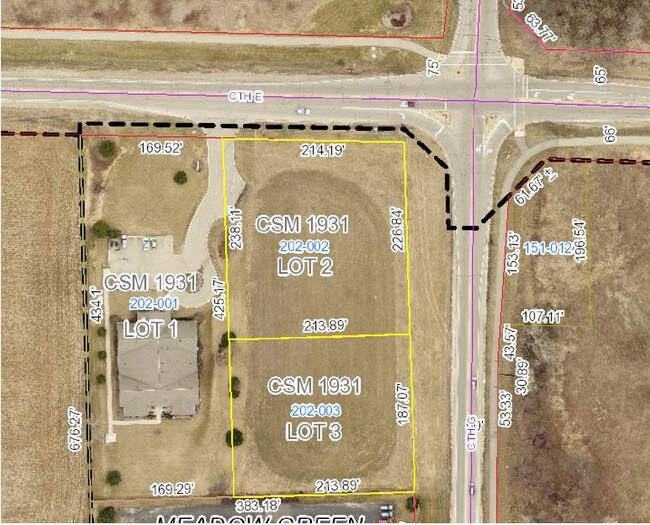
LOT 3 CSM #1931 DOC#1044130 NE 1/4 OF NW 1/4 SEC 13 T2 R22 (1997 PT 07-222-13-202-155 & -110) .92 AC
07-222-13-202-002
KENOSHA
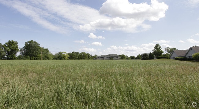
Agriculturalland
Wisconsin
B2
3
B and X Area of moderate flood hazard, usually the area between the limits of the 100-year and 500-year floods.
1.12 AC
2025
Kenosha East
2025
Chicago
000603
NEARBY LISTINGS FOR SALE OR LEASE
DEMOGRAPHICS near 30Th Ave
1 mile
3 mile
5 mile
2025 Total Population
5,691
34,191
102,884
2030 Population
5,654
34,191
102,187
Pop Growth 2025-2030
(0.65%)
0.00%
(0.68%)
Average Age
41
41
40
2025 Total Households
2,703
13,925
41,161
HH Growth 2025-2030
(0.59%)
+ 0.05%
(0.67%)
Median Household Inc
$48,954
$69,691
$64,932
Avg Household Size
2.00
2.20
2.30
2025 Avg HH Vehicles
2.00
2.00
2.00
Median Home Value
$338,868
$272,185
$215,347
Median Year Built
1992
1979
1967
Nearby Places
Map Layers
Map Styles
 Street
 Aerial
Transit
 Traffic
 Biking
Places
Listings with unknown addresses are not visible on the map
- Restaurants
- Banks
- Shops
- Fitness
- Groceries
PUBLIC TRANSPORTATION
COMMUTER RAIL
Kenosha Station (Union Pacific North Line - Northeast Illinois Regional Commuter Railroad (Metra))
Drive
Walk
Distance
Kenosha Station (Union Pacific North Line - Northeast Illinois Regional Commuter Railroad (Metra))
11 min
4.6 mi
Sturtevant Amtrak Station (Hiawatha Service - Amtrak)
Drive
Walk
Distance
Sturtevant Amtrak Station (Hiawatha Service - Amtrak)
17 min
9.2 mi
AIRPORT
General Mitchell International
Drive
Walk
Distance
General Mitchell International
38 min
28.4 mi
Freight Ports
Port Milwaukee
Drive
Walk
Distance
Port Milwaukee
42 min
32.3 mi
Nearby Properties
Address
Land Use
TOTAL SIZE
Lot Size
Zoning
Address
Land Use
TOTAL SIZE
Lot Size
Zoning
3,886 SF
20.04 AC
Address
Land Use
TOTAL SIZE
Lot Size
Zoning
773 SF
21.36 AC
Address
Land Use
TOTAL SIZE
Lot Size
Zoning
26,016 SF
14.02 AC
FW
Address
Land Use
TOTAL SIZE
Lot Size
Zoning
451,022 SF
30.04 AC
Address
Land Use
TOTAL SIZE
Lot Size
Zoning
21,072 SF
24.33 AC
RM2
Address
Land Use
TOTAL SIZE
Lot Size
Zoning
16,466 SF
19.09 AC
RM2
Address
Land Use
TOTAL SIZE
Lot Size
Zoning
26,500 SF
17.79 AC
RM2
Address
Land Use
TOTAL SIZE
Lot Size
Zoning
32,245 SF
22 AC
RM2
Address
Land Use
TOTAL SIZE
Lot Size
Zoning
183,173 SF
9.73 AC
RM3
Address
Land Use
TOTAL SIZE
Lot Size
Zoning
26.05 AC
Address
Land Use
TOTAL SIZE
Lot Size
Zoning
85,469 SF
11.30 AC
Address
Land Use
TOTAL SIZE
Lot Size
Zoning
176,978 SF
24.81 AC
Address
Land Use
TOTAL SIZE
Lot Size
Zoning
31,650 SF
7.62 AC
FW
Address
Land Use
TOTAL SIZE
Lot Size
Zoning
319,640 SF
19.20 AC
M1
Address
Land Use
TOTAL SIZE
Lot Size
Zoning
88,473 SF
8.98 AC
B2
Address
Land Use
TOTAL SIZE
Lot Size
Zoning
15,084 SF
34.20 AC
Address
Land Use
TOTAL SIZE
Lot Size
Zoning
25,775 SF
3.43 AC
Address
Land Use
TOTAL SIZE
Lot Size
Zoning
9,860 SF
14.55 AC
RM2
Address
Land Use
TOTAL SIZE
Lot Size
Zoning
134,270 SF
17.17 AC
Address
Land Use
TOTAL SIZE
Lot Size
Zoning
32,000 SF
3.97 AC
IP
Address
Land Use
TOTAL SIZE
Lot Size
Zoning
59,660 SF
1.22 AC
RM3
Address
Land Use
TOTAL SIZE
Lot Size
Zoning
10,170 SF
4.16 AC
Address
Land Use
TOTAL SIZE
Lot Size
Zoning
12,420 SF
6.58 AC
RM2
Address
Land Use
TOTAL SIZE
Lot Size
Zoning
84,950 SF
8.11 AC
Address
Land Use
TOTAL SIZE
Lot Size
Zoning
49,528 SF
4.73 AC
B2
Address
Land Use
TOTAL SIZE
Lot Size
Zoning
75,932 SF
4.10 AC
RM2
Address
Land Use
TOTAL SIZE
Lot Size
Zoning
45,608 SF
1.31 AC
IP
Address
Land Use
TOTAL SIZE
Lot Size
Zoning
26,162 SF
3.58 AC
RM2
Address
Land Use
TOTAL SIZE
Lot Size
Zoning
625 SF
3.21 AC
Address
Land Use
TOTAL SIZE
Lot Size
Zoning
16,222 SF
2.44 AC
RM2
The World's #1 Commercial Real Estate Marketplace
Connect with us
© 2026 CoStar Group
The information above has been obtained from sources believed reliable. While we do not doubt its accuracy we have not verified it and make no guarantee, warranty or representation about it. It is your responsibility to independently confirm its accuracy and completeness. Any projections, opinions, assumptions, or estimates used are for example only and do not represent the current or future performance of the property. The value of this transaction to you depends on tax and other factors which should be evaluated by your tax, financial, and legal advisors. You and your advisors should conduct a careful, independent investigation of the property to determine to your satisfaction the suitability of the property for your needs.