Property Record
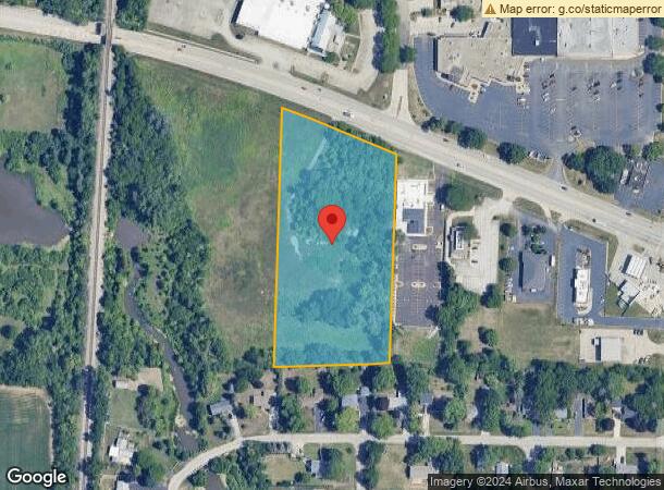
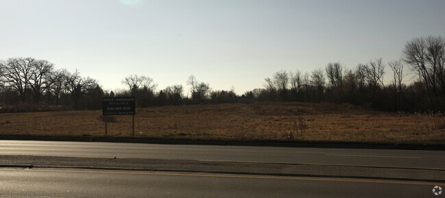
30W131 Roosevelt Rd, West Chicago, IL 60185

This Property Is For Sale
NEARBY LISTINGS FOR SALE OR LEASE
Property Detail
30W131 Roosevelt Rd
Chicago
West Park
Chicago-Naperville-Elgin, IL-IN-WI
DuPage
04-16-206-002
Illinois
Sfr
4.49 AC
X
Western East/West Corr
17043C0127J
DEMOGRAPHICS near 30W131 Roosevelt Rd
1 Mile
3 Mile
5 Mile
2024 Total Population
8,711
33,806
110,238
2029 Population
8,452
32,449
107,256
Pop Growth 2024-2029
(2.97%)
(4.01%)
(2.71%)
Average Age
36
38
41
2024 Total Households
2,336
10,838
39,293
HH Growth 2024-2029
(3.42%)
(4.59%)
(2.72%)
Median Household Inc
$78,763
$83,513
$104,226
Avg Household Size
3.40
3.00
2.70
2024 Avg HH Vehicles
2.00
2.00
2.00
Median Home Value
$226,652
$258,066
$319,573
Median Year Built
1969
1976
1981
Nearby Places
Map Layers
Map Styles
 Street
 Aerial
- Restaurants
- Banks
- Shops
- Fitness
- Groceries
PUBLIC TRANSPORTATION
COMMUTER RAIL
West Chicago Station (Union Pacific West Line - Northeast Illinois Regional Commuter Railroad (Metra))
DRIVE
WALK
Distance
West Chicago Station (Union Pacific West Line - Northeast Illinois Regional Commuter Railroad (Metra))
6 min
2.5 mi
Winfield Station (Union Pacific West Line - Northeast Illinois Regional Commuter Railroad (Metra))
DRIVE
WALK
Distance
Winfield Station (Union Pacific West Line - Northeast Illinois Regional Commuter Railroad (Metra))
7 min
3.5 mi
AIRPORT
Chicago O'Hare International
DRIVE
WALK
Distance
Chicago O'Hare International
58 min
24.6 mi
Chicago Midway International
DRIVE
WALK
Distance
Chicago Midway International
56 min
29.8 mi
Nearby Properties
Address
Land Use
TOTAL SIZE
Lot Size
Zoning
Address
Land Use
TOTAL SIZE
Lot Size
Zoning
38.68 AC
Address
Land Use
TOTAL SIZE
Lot Size
Zoning
42.27 AC
Address
Land Use
TOTAL SIZE
Lot Size
Zoning
26,302 SF
2.09 AC
C
Address
Land Use
TOTAL SIZE
Lot Size
Zoning
Address
Land Use
TOTAL SIZE
Lot Size
Zoning
Address
Land Use
TOTAL SIZE
Lot Size
Zoning
26.41 AC
Address
Land Use
TOTAL SIZE
Lot Size
Zoning
28.84 AC
Address
Land Use
TOTAL SIZE
Lot Size
Zoning
Address
Land Use
TOTAL SIZE
Lot Size
Zoning
291,360 SF
14.55 AC
Address
Land Use
TOTAL SIZE
Lot Size
Zoning
277,018 SF
12.36 AC
I
Address
Land Use
TOTAL SIZE
Lot Size
Zoning
Address
Land Use
TOTAL SIZE
Lot Size
Zoning
242,748 SF
11.65 AC
R
Address
Land Use
TOTAL SIZE
Lot Size
Zoning
18.30 AC
Address
Land Use
TOTAL SIZE
Lot Size
Zoning
21.14 AC
Address
Land Use
TOTAL SIZE
Lot Size
Zoning
13.15 AC
R
Address
Land Use
TOTAL SIZE
Lot Size
Zoning
258,240 SF
10.51 AC
Address
Land Use
TOTAL SIZE
Lot Size
Zoning
39.42 AC
Address
Land Use
TOTAL SIZE
Lot Size
Zoning
11.25 AC
Address
Land Use
TOTAL SIZE
Lot Size
Zoning
22.10 AC
Address
Land Use
TOTAL SIZE
Lot Size
Zoning
16.68 AC
I
Address
Land Use
TOTAL SIZE
Lot Size
Zoning
168,302 SF
13.78 AC
I
Address
Land Use
TOTAL SIZE
Lot Size
Zoning
12.51 AC
Address
Land Use
TOTAL SIZE
Lot Size
Zoning
252,280 SF
9.81 AC
Address
Land Use
TOTAL SIZE
Lot Size
Zoning
Address
Land Use
TOTAL SIZE
Lot Size
Zoning
Address
Land Use
TOTAL SIZE
Lot Size
Zoning
409,705 SF
16.21 AC
I
Address
Land Use
TOTAL SIZE
Lot Size
Zoning
291,219 SF
12.25 AC
I
Address
Land Use
TOTAL SIZE
Lot Size
Zoning
1,808 SF
0.19 AC
C
Address
Land Use
TOTAL SIZE
Lot Size
Zoning
169,950 SF
13.85 AC
C
Address
Land Use
TOTAL SIZE
Lot Size
Zoning
137,196 SF
8.82 AC
R
The World's #1 Commercial Real Estate Marketplace
Connect with us
© 2025 CoStar Group
The information above has been obtained from sources believed reliable. While we do not doubt its accuracy we have not verified it and make no guarantee, warranty or representation about it. It is your responsibility to independently confirm its accuracy and completeness. Any projections, opinions, assumptions, or estimates used are for example only and do not represent the current or future performance of the property. The value of this transaction to you depends on tax and other factors which should be evaluated by your tax, financial, and legal advisors. You and your advisors should conduct a careful, independent investigation of the property to determine to your satisfaction the suitability of the property for your needs.