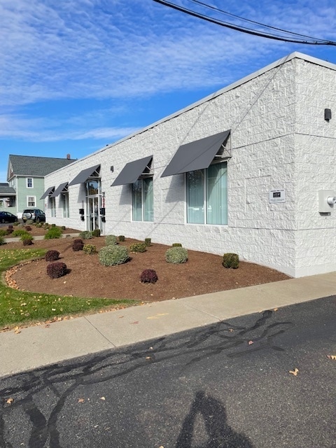
Property Record
29 Adams Ave, Endicott, NY 13760


Current Lease Availabilities
NEARBY LISTINGS FOR SALE OR LEASE
Property Detail
29 Adams Ave
Syracuse
Endicott Land Company Subdivision Plot #
Binghamton, NY
IND BLDG 0020K6020616X0000000
034601-157-007-0002-025-000-0000
Broome
Officebuilding
New York
2025
25.000
2024
0.84 AC
013500
Broome County
9,810 SF
DEMOGRAPHICS near 29 Adams Ave
1 Mile
3 Mile
5 Mile
2024 Total Population
11,998
47,719
86,238
2029 Population
11,641
46,628
84,435
Pop Growth 2024-2029
(2.98%)
(2.29%)
(2.09%)
Average Age
40
43
41
2024 Total Households
5,337
20,771
33,839
HH Growth 2024-2029
(3.19%)
(2.46%)
(2.36%)
Median Household Inc
$45,017
$63,391
$60,185
Avg Household Size
2.10
2.20
2.20
2024 Avg HH Vehicles
1.00
2.00
2.00
Median Home Value
$97,839
$149,293
$146,594
Median Year Built
1948
1957
1958
Nearby Places
Map Layers
Map Styles
 Street
 Aerial
- Restaurants
- Banks
- Shops
- Fitness
- Groceries
PUBLIC TRANSPORTATION
AIRPORT
Greater Binghamtonl-Edwin A. Link Field
DRIVE
WALK
Distance
Greater Binghamtonl-Edwin A. Link Field
21 min
14.9 mi
Freight Ports
Albany, NY Port
DRIVE
WALK
Distance
Albany, NY Port
1 min
122.1 mi
Nearby Properties
Address
Land Use
TOTAL SIZE
Lot Size
Zoning
Address
Land Use
TOTAL SIZE
Lot Size
Zoning
Address
Land Use
TOTAL SIZE
Lot Size
Zoning
203,306 SF
30.33 AC
C-2
Address
Land Use
TOTAL SIZE
Lot Size
Zoning
198,892 SF
40.31 AC
RR
Address
Land Use
TOTAL SIZE
Lot Size
Zoning
124,053 SF
7.63 AC
RC
Address
Land Use
TOTAL SIZE
Lot Size
Zoning
206,537 SF
15.02 AC
C-2
Address
Land Use
TOTAL SIZE
Lot Size
Zoning
117,267 SF
17.65 AC
C-2
Address
Land Use
TOTAL SIZE
Lot Size
Zoning
93,010 SF
12.32 AC
Address
Land Use
TOTAL SIZE
Lot Size
Zoning
126,000 SF
10.76 AC
C-2
Address
Land Use
TOTAL SIZE
Lot Size
Zoning
139,175 SF
13.43 AC
C-2
Address
Land Use
TOTAL SIZE
Lot Size
Zoning
135,382 SF
14.47 AC
Address
Land Use
TOTAL SIZE
Lot Size
Zoning
68,546 SF
28.40 AC
Address
Land Use
TOTAL SIZE
Lot Size
Zoning
87,842 SF
7.73 AC
C-2
Address
Land Use
TOTAL SIZE
Lot Size
Zoning
18,104 SF
9.94 AC
RC
Address
Land Use
TOTAL SIZE
Lot Size
Zoning
71,076 SF
12.22 AC
RR
Address
Land Use
TOTAL SIZE
Lot Size
Zoning
Address
Land Use
TOTAL SIZE
Lot Size
Zoning
122,980 SF
5.85 AC
RC
Address
Land Use
TOTAL SIZE
Lot Size
Zoning
24,600 SF
8.75 AC
RC
Address
Land Use
TOTAL SIZE
Lot Size
Zoning
33,600 SF
7.16 AC
RC
Address
Land Use
TOTAL SIZE
Lot Size
Zoning
58,604 SF
6.02 AC
I
Address
Land Use
TOTAL SIZE
Lot Size
Zoning
12,665 SF
2.65 AC
C-1
Address
Land Use
TOTAL SIZE
Lot Size
Zoning
74,394 SF
7.51 AC
C-2
Address
Land Use
TOTAL SIZE
Lot Size
Zoning
7,452 SF
3.47 AC
C-1
Address
Land Use
TOTAL SIZE
Lot Size
Zoning
8,840 SF
5.90 AC
RC
Address
Land Use
TOTAL SIZE
Lot Size
Zoning
29,750 SF
14.38 AC
RA-2
Address
Land Use
TOTAL SIZE
Lot Size
Zoning
69,590 SF
8.51 AC
C-1
Address
Land Use
TOTAL SIZE
Lot Size
Zoning
51,861 SF
13.44 AC
RA-2
Address
Land Use
TOTAL SIZE
Lot Size
Zoning
58,480 SF
2.60 AC
C-2
Address
Land Use
TOTAL SIZE
Lot Size
Zoning
45,398 SF
1.29 AC
C-2
Address
Land Use
TOTAL SIZE
Lot Size
Zoning
15,624 SF
4.08 AC
RR
Address
Land Use
TOTAL SIZE
Lot Size
Zoning
31,973 SF
4.11 AC
C-2
The World's #1 Commercial Real Estate Marketplace
Connect with us
© 2026 CoStar Group
The information above has been obtained from sources believed reliable. While we do not doubt its accuracy we have not verified it and make no guarantee, warranty or representation about it. It is your responsibility to independently confirm its accuracy and completeness. Any projections, opinions, assumptions, or estimates used are for example only and do not represent the current or future performance of the property. The value of this transaction to you depends on tax and other factors which should be evaluated by your tax, financial, and legal advisors. You and your advisors should conduct a careful, independent investigation of the property to determine to your satisfaction the suitability of the property for your needs.