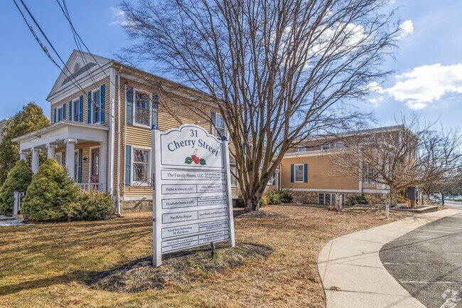
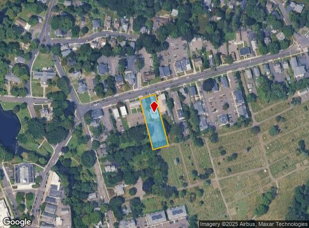
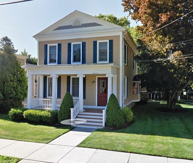
Property Record
108 Thornton St, Milford, CT 06461
Current Lease Availabilities
NEARBY LISTINGS FOR SALE OR LEASE
Property Detail
108 Thornton St
New Haven-Milford, CT
New Haven
MILF-000032-000350-000021
Connecticut
Sfr
0.38 AC
X
Milford
09001C0453G
Westchester/So Connecticut
1,288 SF
DEMOGRAPHICS near 108 Thornton St
1 Mile
3 Mile
5 Mile
2024 Total Population
9,109
48,863
113,853
2029 Population
9,169
49,192
114,457
Pop Growth 2024-2029
+ 0.66%
+ 0.67%
+ 0.53%
Average Age
44
44
45
2024 Total Households
4,034
20,853
47,006
HH Growth 2024-2029
+ 0.57%
+ 0.66%
+ 0.54%
Median Household Inc
$97,035
$100,517
$101,115
Avg Household Size
2.20
2.30
2.40
2024 Avg HH Vehicles
2.00
2.00
2.00
Median Home Value
$382,152
$355,761
$333,920
Median Year Built
1959
1966
1964
Nearby Places
Map Layers
Map Styles
 Street
 Aerial
- Restaurants
- Banks
- Shops
- Fitness
- Groceries
PUBLIC TRANSPORTATION
TRANSIT/SUBWAY
Milford Station (New Haven Line - Metro-North Commuter Railroad Company (Metro-North))
DRIVE
WALK
Distance
Milford Station (New Haven Line - Metro-North Commuter Railroad Company (Metro-North))
1 min
8 min
0.4 mi
COMMUTER RAIL
Milford Station (New Haven Line - Metro-North Commuter Railroad Company (Metro-North))
DRIVE
WALK
Distance
Milford Station (New Haven Line - Metro-North Commuter Railroad Company (Metro-North))
1 min
8 min
0.4 mi
Stratford Station (New Haven Line - Metro-North Commuter Railroad Company (Metro-North))
DRIVE
WALK
Distance
Stratford Station (New Haven Line - Metro-North Commuter Railroad Company (Metro-North))
9 min
5.2 mi
AIRPORT
Tweed/New Haven
DRIVE
WALK
Distance
Tweed/New Haven
24 min
13.6 mi
Long Island MacArthur
DRIVE
WALK
Distance
Long Island MacArthur
122 min
43.2 mi
Westchester County
DRIVE
WALK
Distance
Westchester County
63 min
45.2 mi
Freight Ports
Port of New Haven
DRIVE
WALK
Distance
Port of New Haven
19 min
10.8 mi
Nearby Properties
Address
Land Use
TOTAL SIZE
Lot Size
Zoning
Address
Land Use
TOTAL SIZE
Lot Size
Zoning
187,983 SF
254.30 AC
H-3
Address
Land Use
TOTAL SIZE
Lot Size
Zoning
74.86 AC
SCD
Address
Land Use
TOTAL SIZE
Lot Size
Zoning
9.05 AC
MCDD
Address
Land Use
TOTAL SIZE
Lot Size
Zoning
1,628 SF
22.65 AC
OSAH
Address
Land Use
TOTAL SIZE
Lot Size
Zoning
34.40 AC
SCD
Address
Land Use
TOTAL SIZE
Lot Size
Zoning
28.30 AC
HDD
Address
Land Use
TOTAL SIZE
Lot Size
Zoning
1,110 SF
6.76 AC
CDD1
Address
Land Use
TOTAL SIZE
Lot Size
Zoning
3,864 SF
26.06 AC
DO25
Address
Land Use
TOTAL SIZE
Lot Size
Zoning
6.86 AC
RA
Address
Land Use
TOTAL SIZE
Lot Size
Zoning
31.70 AC
R30
Address
Land Use
TOTAL SIZE
Lot Size
Zoning
26,736 SF
10.86 AC
CDD1
Address
Land Use
TOTAL SIZE
Lot Size
Zoning
745,516 SF
32.74 AC
HDD
Address
Land Use
TOTAL SIZE
Lot Size
Zoning
145,145 SF
22.60 AC
MCDD
Address
Land Use
TOTAL SIZE
Lot Size
Zoning
181,277 SF
4.58 AC
CDD5
Address
Land Use
TOTAL SIZE
Lot Size
Zoning
160,957 SF
26.40 AC
R12.
Address
Land Use
TOTAL SIZE
Lot Size
Zoning
14.69 AC
WDD
Address
Land Use
TOTAL SIZE
Lot Size
Zoning
2.91 AC
MCDD
Address
Land Use
TOTAL SIZE
Lot Size
Zoning
7.54 AC
CDD5
Address
Land Use
TOTAL SIZE
Lot Size
Zoning
18.14 AC
ID
Address
Land Use
TOTAL SIZE
Lot Size
Zoning
15.51 AC
C-2
Address
Land Use
TOTAL SIZE
Lot Size
Zoning
138,970 SF
14.34 AC
CDD5
Address
Land Use
TOTAL SIZE
Lot Size
Zoning
21.50 AC
LI
Address
Land Use
TOTAL SIZE
Lot Size
Zoning
29.18 AC
MCDD
Address
Land Use
TOTAL SIZE
Lot Size
Zoning
138,255 SF
15.29 AC
ID
Address
Land Use
TOTAL SIZE
Lot Size
Zoning
141,025 SF
12.30 AC
SCD
Address
Land Use
TOTAL SIZE
Lot Size
Zoning
70,576 SF
5.97 AC
H-4
Address
Land Use
TOTAL SIZE
Lot Size
Zoning
55,770 SF
5.97 AC
CDD1
Address
Land Use
TOTAL SIZE
Lot Size
Zoning
47.01 AC
DO25
Address
Land Use
TOTAL SIZE
Lot Size
Zoning
68,404 SF
10.91 AC
CDD3
Address
Land Use
TOTAL SIZE
Lot Size
Zoning
78,448 SF
6.95 AC
C-2
The World's #1 Commercial Real Estate Marketplace
Connect with us
© 2025 CoStar Group
The information above has been obtained from sources believed reliable. While we do not doubt its accuracy we have not verified it and make no guarantee, warranty or representation about it. It is your responsibility to independently confirm its accuracy and completeness. Any projections, opinions, assumptions, or estimates used are for example only and do not represent the current or future performance of the property. The value of this transaction to you depends on tax and other factors which should be evaluated by your tax, financial, and legal advisors. You and your advisors should conduct a careful, independent investigation of the property to determine to your satisfaction the suitability of the property for your needs.