Property Record
31 Conway Rd, Marlboro, NY 12542
NEARBY LISTINGS FOR SALE OR LEASE
Property Detail
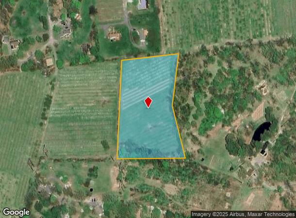
31 Conway Rd
334600-008-000-0001-024.000-0000
Orange
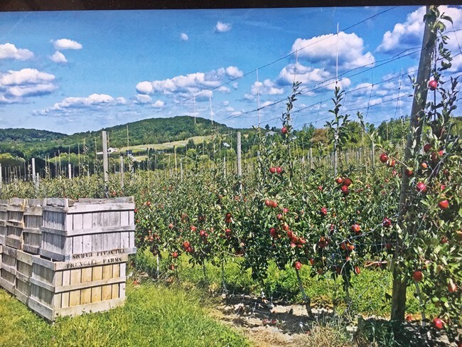
Orchard
New York
X
24.00
36027C0453E
4.90 AC
2024
Newburgh
2024
Northern New Jersey
010102
New York-Jersey City-White Plains, NY-NJ
DEMOGRAPHICS near 31 Conway Rd
1 Mile
3 Mile
5 Mile
2024 Total Population
1,108
11,974
51,841
2029 Population
1,107
11,973
52,032
Pop Growth 2024-2029
(0.09%)
(0.01%)
+ 0.37%
Average Age
42
42
42
2024 Total Households
429
4,706
20,078
HH Growth 2024-2029
0.00%
(0.02%)
+ 0.31%
Median Household Inc
$120,601
$107,581
$94,439
Avg Household Size
2.60
2.50
2.40
2024 Avg HH Vehicles
2.00
2.00
2.00
Median Home Value
$409,091
$355,110
$339,272
Median Year Built
1980
1977
1974
Nearby Places
Map Layers
Map Styles
 Street
 Aerial
- Restaurants
- Banks
- Shops
- Fitness
- Groceries
PUBLIC TRANSPORTATION
COMMUTER RAIL
Beacon Station (Hudson Line - Metro-North Commuter Railroad Company (Metro-North))
DRIVE
WALK
Distance
Beacon Station (Hudson Line - Metro-North Commuter Railroad Company (Metro-North))
16 min
9.4 mi
AIRPORT
New York Stewart International
DRIVE
WALK
Distance
New York Stewart International
23 min
13.1 mi
Freight Ports
Port of New Haven
DRIVE
WALK
Distance
Port of New Haven
109 min
79.9 mi
SALE & LEASE HISTORY
LISTING DATE
SALE/LEASE

Feb 07, 2018
For Sale
Nearby Properties
Address
Land Use
TOTAL SIZE
Lot Size
Zoning
Address
Land Use
TOTAL SIZE
Lot Size
Zoning
Address
Land Use
TOTAL SIZE
Lot Size
Zoning
114 AC
Address
Land Use
TOTAL SIZE
Lot Size
Zoning
11.76 AC
R4A
Address
Land Use
TOTAL SIZE
Lot Size
Zoning
141,167 SF
46.50 AC
R1
Address
Land Use
TOTAL SIZE
Lot Size
Zoning
1,095 SF
21.70 AC
R1
Address
Land Use
TOTAL SIZE
Lot Size
Zoning
50.90 AC
Address
Land Use
TOTAL SIZE
Lot Size
Zoning
35 AC
R40
Address
Land Use
TOTAL SIZE
Lot Size
Zoning
43,877 SF
10.10 AC
R1
Address
Land Use
TOTAL SIZE
Lot Size
Zoning
Address
Land Use
TOTAL SIZE
Lot Size
Zoning
22 AC
R40
Address
Land Use
TOTAL SIZE
Lot Size
Zoning
247.75 AC
R4A
Address
Land Use
TOTAL SIZE
Lot Size
Zoning
138.90 AC
Address
Land Use
TOTAL SIZE
Lot Size
Zoning
54,908 SF
7.60 AC
HD
Address
Land Use
TOTAL SIZE
Lot Size
Zoning
14.30 AC
RAG1
Address
Land Use
TOTAL SIZE
Lot Size
Zoning
32.30 AC
RMF5
Address
Land Use
TOTAL SIZE
Lot Size
Zoning
11,367 SF
14.97 AC
R80
Address
Land Use
TOTAL SIZE
Lot Size
Zoning
50,657 SF
15.60 AC
R1
Address
Land Use
TOTAL SIZE
Lot Size
Zoning
161,390 SF
21.20 AC
HD
Address
Land Use
TOTAL SIZE
Lot Size
Zoning
43,633 SF
99.63 AC
R80
Address
Land Use
TOTAL SIZE
Lot Size
Zoning
28,422 SF
38.70 AC
R40/80
Address
Land Use
TOTAL SIZE
Lot Size
Zoning
Address
Land Use
TOTAL SIZE
Lot Size
Zoning
40.30 AC
Address
Land Use
TOTAL SIZE
Lot Size
Zoning
3.50 AC
HB
Address
Land Use
TOTAL SIZE
Lot Size
Zoning
1,428 SF
19.85 AC
RAG1
Address
Land Use
TOTAL SIZE
Lot Size
Zoning
Address
Land Use
TOTAL SIZE
Lot Size
Zoning
Address
Land Use
TOTAL SIZE
Lot Size
Zoning
26,716 SF
3.30 AC
HD
Address
Land Use
TOTAL SIZE
Lot Size
Zoning
11,538 SF
2.79 AC
R20
Address
Land Use
TOTAL SIZE
Lot Size
Zoning
Address
Land Use
TOTAL SIZE
Lot Size
Zoning
The World's #1 Commercial Real Estate Marketplace
Connect with us
© 2025 CoStar Group
The information above has been obtained from sources believed reliable. While we do not doubt its accuracy we have not verified it and make no guarantee, warranty or representation about it. It is your responsibility to independently confirm its accuracy and completeness. Any projections, opinions, assumptions, or estimates used are for example only and do not represent the current or future performance of the property. The value of this transaction to you depends on tax and other factors which should be evaluated by your tax, financial, and legal advisors. You and your advisors should conduct a careful, independent investigation of the property to determine to your satisfaction the suitability of the property for your needs.