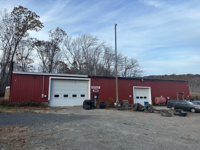
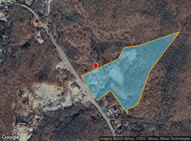
Property Record
31 Route 2, Preston, CT 06365
NEARBY LISTINGS FOR SALE OR LEASE
-
-
View all Preston listings for lease on LoopNet.com
Property Detail
31 Route 2
PRES-000170-000002-000031
New London
Commercialnec
Connecticut
X
31
09011C0218G
24.75 AC
2024
NE New London/Norwich
2025
Hartford
700100
Norwich-New London, CT
DEMOGRAPHICS near 31 Route 2
1 Mile
3 Mile
5 Mile
2024 Total Population
1,377
28,642
52,575
2029 Population
1,373
28,618
52,380
Pop Growth 2024-2029
(0.29%)
(0.08%)
(0.37%)
Average Age
41
39
41
2024 Total Households
656
11,828
21,386
HH Growth 2024-2029
(0.46%)
(0.07%)
(0.40%)
Median Household Inc
$47,131
$57,324
$67,146
Avg Household Size
2.10
2.30
2.40
2024 Avg HH Vehicles
2.00
2.00
2.00
Median Home Value
$296,153
$193,745
$228,379
Median Year Built
1962
1952
1960
Nearby Places
- Restaurants
- Banks
- Shops
- Fitness
- Groceries
SALE & LEASE HISTORY
LISTING DATE
SALE/LEASE

Dec 03, 2023
For Lease
Apr 03, 2025
For Lease
Nearby Properties
Address
Land Use
TOTAL SIZE
Lot Size
Zoning
Address
Land Use
TOTAL SIZE
Lot Size
Zoning
45.74 AC
PDD
Address
Land Use
TOTAL SIZE
Lot Size
Zoning
242 AC
R20
Address
Land Use
TOTAL SIZE
Lot Size
Zoning
200,847 SF
14.30 AC
R40
Address
Land Use
TOTAL SIZE
Lot Size
Zoning
4.59 AC
TRDD
Address
Land Use
TOTAL SIZE
Lot Size
Zoning
16 AC
ROS
Address
Land Use
TOTAL SIZE
Lot Size
Zoning
Address
Land Use
TOTAL SIZE
Lot Size
Zoning
13.78 AC
R40
Address
Land Use
TOTAL SIZE
Lot Size
Zoning
2,102 SF
110.90 AC
PDD
Address
Land Use
TOTAL SIZE
Lot Size
Zoning
16,551 SF
18.11 AC
MF
Address
Land Use
TOTAL SIZE
Lot Size
Zoning
128,565 SF
18.90 AC
R40
Address
Land Use
TOTAL SIZE
Lot Size
Zoning
129,948 SF
9.70 AC
PC
Address
Land Use
TOTAL SIZE
Lot Size
Zoning
8.78 AC
MF
Address
Land Use
TOTAL SIZE
Lot Size
Zoning
18,401 SF
12.88 AC
MF
Address
Land Use
TOTAL SIZE
Lot Size
Zoning
87,162 SF
30.20 AC
R20/MF
Address
Land Use
TOTAL SIZE
Lot Size
Zoning
79,192 SF
11.90 AC
MF
Address
Land Use
TOTAL SIZE
Lot Size
Zoning
6.39 AC
MF
Address
Land Use
TOTAL SIZE
Lot Size
Zoning
3.76 AC
MF
Address
Land Use
TOTAL SIZE
Lot Size
Zoning
351.80 AC
ROS
Address
Land Use
TOTAL SIZE
Lot Size
Zoning
15,208 SF
205.14 AC
TRDD
Address
Land Use
TOTAL SIZE
Lot Size
Zoning
11.23 AC
MF
Address
Land Use
TOTAL SIZE
Lot Size
Zoning
51,154 SF
0.38 AC
CC
Address
Land Use
TOTAL SIZE
Lot Size
Zoning
42,127 SF
0.63 AC
CC
Address
Land Use
TOTAL SIZE
Lot Size
Zoning
23.24 AC
RSRVT
Address
Land Use
TOTAL SIZE
Lot Size
Zoning
10.95 AC
PC
Address
Land Use
TOTAL SIZE
Lot Size
Zoning
79,686 SF
0.13 AC
WD
Address
Land Use
TOTAL SIZE
Lot Size
Zoning
24.76 AC
R20
Address
Land Use
TOTAL SIZE
Lot Size
Zoning
78,364 SF
4.88 AC
GC
Address
Land Use
TOTAL SIZE
Lot Size
Zoning
4,200 SF
14.98 AC
MF
Address
Land Use
TOTAL SIZE
Lot Size
Zoning
37,360 SF
2 AC
R20
Address
Land Use
TOTAL SIZE
Lot Size
Zoning
8.43 AC
R40
The World's #1 Commercial Real Estate Marketplace
Connect with us
© 2025 CoStar Group
The information above has been obtained from sources believed reliable. While we do not doubt its accuracy we have not verified it and make no guarantee, warranty or representation about it. It is your responsibility to independently confirm its accuracy and completeness. Any projections, opinions, assumptions, or estimates used are for example only and do not represent the current or future performance of the property. The value of this transaction to you depends on tax and other factors which should be evaluated by your tax, financial, and legal advisors. You and your advisors should conduct a careful, independent investigation of the property to determine to your satisfaction the suitability of the property for your needs.