Property Record
31 E Brookfield Rd, North Brookfield, MA 01535
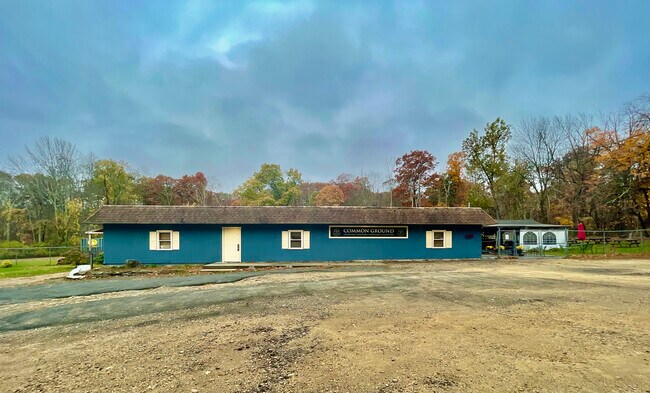

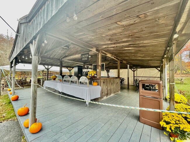
Property Detail
31 E Brookfield Rd
NBFD-000038-000057-000310
Worcester
Restaurantbuilding
Massachusetts
BG
310
2025
3.01 AC
2025
Outlying Worcester
725100
Boston
2,660 SF
Worcester, MA
NEARBY LISTINGS FOR SALE OR LEASE
-
-
View all North Brookfield listings for sale on LoopNet.com
DEMOGRAPHICS near 31 E Brookfield Rd
1 mile
3 mile
5 mile
2025 Total Population
1,231
7,432
20,883
2030 Population
1,263
7,620
21,365
Pop Growth 2025-2030
+ 2.60%
+ 2.53%
+ 2.31%
Average Age
43
44
44
2025 Total Households
512
3,042
8,904
HH Growth 2025-2030
+ 2.54%
+ 2.56%
+ 2.39%
Median Household Inc
$83,231
$84,375
$74,033
Avg Household Size
2.40
2.40
2.30
2025 Avg HH Vehicles
2.00
2.00
2.00
Median Home Value
$338,461
$372,769
$366,138
Median Year Built
1953
1957
1960
Nearby Places
Map Layers
Map Styles
 Street
 Aerial
Layers
 Traffic
 Biking
Places
Listings with unknown addresses are not visible on the map
- Restaurants
- Banks
- Shops
- Fitness
- Groceries
PUBLIC TRANSPORTATION
AIRPORT
Worcester Regional
Drive
Walk
Distance
Worcester Regional
34 min
16.2 mi
Bradley International
Drive
Walk
Distance
Bradley International
84 min
48.2 mi
Freight Ports
Port of Davisville, RI
Drive
Walk
Distance
Port of Davisville, RI
106 min
74.9 mi
SALE & LEASE HISTORY
LISTING DATE
SALE/LEASE

Oct 28, 2022
For Sale
Nearby Properties
Address
Land Use
TOTAL SIZE
Lot Size
Zoning
Address
Land Use
TOTAL SIZE
Lot Size
Zoning
228,017 SF
62.25 AC
11
Address
Land Use
TOTAL SIZE
Lot Size
Zoning
104,040 SF
17.14 AC
V
Address
Land Use
TOTAL SIZE
Lot Size
Zoning
31,680 SF
6 AC
C
Address
Land Use
TOTAL SIZE
Lot Size
Zoning
25,000 SF
22.13 AC
C
Address
Land Use
TOTAL SIZE
Lot Size
Zoning
2,272 SF
2.28 AC
11
Address
Land Use
TOTAL SIZE
Lot Size
Zoning
20,700 SF
1.37 AC
BA
Address
Land Use
TOTAL SIZE
Lot Size
Zoning
153,297 SF
15.01 AC
IN
Address
Land Use
TOTAL SIZE
Lot Size
Zoning
137,908 SF
3.99 AC
IN
Address
Land Use
TOTAL SIZE
Lot Size
Zoning
5,044 SF
15.93 AC
IN
Address
Land Use
TOTAL SIZE
Lot Size
Zoning
6,656 SF
27.38 AC
30
Address
Land Use
TOTAL SIZE
Lot Size
Zoning
31,520 SF
4.11 AC
BC
Address
Land Use
TOTAL SIZE
Lot Size
Zoning
1,710 SF
104.70 AC
66
Address
Land Use
TOTAL SIZE
Lot Size
Zoning
7,456 SF
1.17 AC
IN
Address
Land Use
TOTAL SIZE
Lot Size
Zoning
522.88 AC
66
Address
Land Use
TOTAL SIZE
Lot Size
Zoning
64,568 SF
25.09 AC
IN
Address
Land Use
TOTAL SIZE
Lot Size
Zoning
25,217 SF
2.20 AC
C
Address
Land Use
TOTAL SIZE
Lot Size
Zoning
10,986 SF
0.72 AC
V
Address
Land Use
TOTAL SIZE
Lot Size
Zoning
1,164 SF
5.11 AC
C
Address
Land Use
TOTAL SIZE
Lot Size
Zoning
16,082 SF
4.20 AC
R
Address
Land Use
TOTAL SIZE
Lot Size
Zoning
23,860 SF
1.27 AC
BC
Address
Land Use
TOTAL SIZE
Lot Size
Zoning
7,960 SF
0.40 AC
11
Address
Land Use
TOTAL SIZE
Lot Size
Zoning
4,104 SF
2.29 AC
R
Address
Land Use
TOTAL SIZE
Lot Size
Zoning
2,952 SF
1 AC
BC
Address
Land Use
TOTAL SIZE
Lot Size
Zoning
15,158 SF
3.51 AC
66
Address
Land Use
TOTAL SIZE
Lot Size
Zoning
5,380 SF
0.58 AC
BG
Address
Land Use
TOTAL SIZE
Lot Size
Zoning
353.60 AC
RR
Address
Land Use
TOTAL SIZE
Lot Size
Zoning
6,190 SF
0.79 AC
BC
Address
Land Use
TOTAL SIZE
Lot Size
Zoning
17,900 SF
0.97 AC
11
Address
Land Use
TOTAL SIZE
Lot Size
Zoning
76.76 AC
C
Address
Land Use
TOTAL SIZE
Lot Size
Zoning
12,000 SF
13.23 AC
C
The World's #1 Commercial Real Estate Marketplace
Connect with us
© 2026 CoStar Group
The information above has been obtained from sources believed reliable. While we do not doubt its accuracy we have not verified it and make no guarantee, warranty or representation about it. It is your responsibility to independently confirm its accuracy and completeness. Any projections, opinions, assumptions, or estimates used are for example only and do not represent the current or future performance of the property. The value of this transaction to you depends on tax and other factors which should be evaluated by your tax, financial, and legal advisors. You and your advisors should conduct a careful, independent investigation of the property to determine to your satisfaction the suitability of the property for your needs.