Property Record
31 Edwards Ave, Port Edwards, WI 54469
NEARBY LISTINGS FOR SALE OR LEASE
-
-
View all Port Edwards listings for lease on LoopNet.com
Property Detail
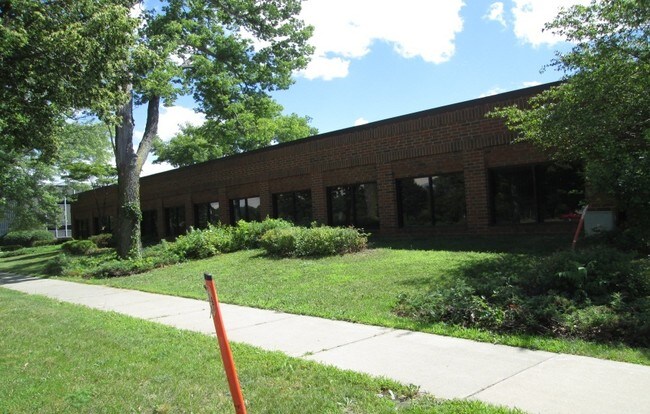
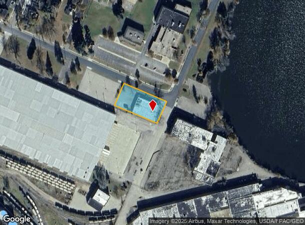
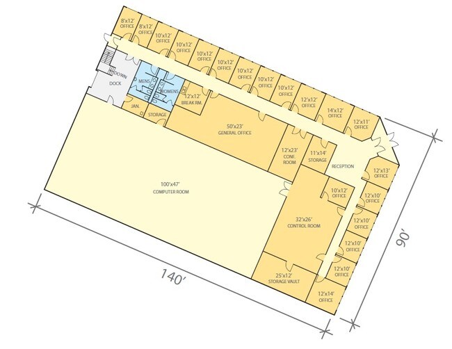
31 Edwards Ave
Wisconsin Rapids-Marshfield, WI
VILLAGE OF PORT EDWARDS S36 T22 R5E LOT 1, WCCSM #10267, BNG PRT GOV'T LOT 4, S 36 T 22 R5E
2700082
Wood
Countyproperty
Wisconsin
X
1,4
55141C0528G
0.80 AC
0
Wausau/Stevens Point
2024
Other Market Areas
011700
DEMOGRAPHICS near 31 Edwards Ave
1 Mile
3 Mile
5 Mile
2024 Total Population
1,182
10,593
29,080
2029 Population
1,175
10,603
28,952
Pop Growth 2024-2029
(0.59%)
+ 0.09%
(0.44%)
Average Age
42
44
43
2024 Total Households
477
4,590
12,759
HH Growth 2024-2029
(0.63%)
+ 0.11%
(0.45%)
Median Household Inc
$52,325
$49,598
$47,788
Avg Household Size
2.40
2.30
2.20
2024 Avg HH Vehicles
2.00
2.00
2.00
Median Home Value
$106,643
$133,912
$130,117
Median Year Built
1953
1971
1969
Nearby Places
Map Layers
Map Styles
 Street
 Aerial
- Restaurants
- Banks
- Shops
- Fitness
- Groceries
PUBLIC TRANSPORTATION
AIRPORT
Central Wisconsin
DRIVE
WALK
Distance
Central Wisconsin
57 min
38.3 mi
SALE & LEASE HISTORY
LISTING DATE
SALE/LEASE

Sep 25, 2016
For Lease
Sep 23, 2016
For Sale
Nearby Properties
Address
Land Use
TOTAL SIZE
Lot Size
Zoning
Address
Land Use
TOTAL SIZE
Lot Size
Zoning
20.39 AC
Address
Land Use
TOTAL SIZE
Lot Size
Zoning
25.90 AC
Address
Land Use
TOTAL SIZE
Lot Size
Zoning
9.33 AC
Address
Land Use
TOTAL SIZE
Lot Size
Zoning
Address
Land Use
TOTAL SIZE
Lot Size
Zoning
Address
Land Use
TOTAL SIZE
Lot Size
Zoning
Address
Land Use
TOTAL SIZE
Lot Size
Zoning
Address
Land Use
TOTAL SIZE
Lot Size
Zoning
6.54 AC
Address
Land Use
TOTAL SIZE
Lot Size
Zoning
Address
Land Use
TOTAL SIZE
Lot Size
Zoning
Address
Land Use
TOTAL SIZE
Lot Size
Zoning
16.98 AC
Address
Land Use
TOTAL SIZE
Lot Size
Zoning
Address
Land Use
TOTAL SIZE
Lot Size
Zoning
Address
Land Use
TOTAL SIZE
Lot Size
Zoning
Address
Land Use
TOTAL SIZE
Lot Size
Zoning
Address
Land Use
TOTAL SIZE
Lot Size
Zoning
Address
Land Use
TOTAL SIZE
Lot Size
Zoning
Address
Land Use
TOTAL SIZE
Lot Size
Zoning
Address
Land Use
TOTAL SIZE
Lot Size
Zoning
Address
Land Use
TOTAL SIZE
Lot Size
Zoning
Address
Land Use
TOTAL SIZE
Lot Size
Zoning
Address
Land Use
TOTAL SIZE
Lot Size
Zoning
Address
Land Use
TOTAL SIZE
Lot Size
Zoning
Address
Land Use
TOTAL SIZE
Lot Size
Zoning
Address
Land Use
TOTAL SIZE
Lot Size
Zoning
Address
Land Use
TOTAL SIZE
Lot Size
Zoning
Address
Land Use
TOTAL SIZE
Lot Size
Zoning
Address
Land Use
TOTAL SIZE
Lot Size
Zoning
Address
Land Use
TOTAL SIZE
Lot Size
Zoning
Address
Land Use
TOTAL SIZE
Lot Size
Zoning
The World's #1 Commercial Real Estate Marketplace
Connect with us
© 2026 CoStar Group
The information above has been obtained from sources believed reliable. While we do not doubt its accuracy we have not verified it and make no guarantee, warranty or representation about it. It is your responsibility to independently confirm its accuracy and completeness. Any projections, opinions, assumptions, or estimates used are for example only and do not represent the current or future performance of the property. The value of this transaction to you depends on tax and other factors which should be evaluated by your tax, financial, and legal advisors. You and your advisors should conduct a careful, independent investigation of the property to determine to your satisfaction the suitability of the property for your needs.