Property Record
31 Hall Dr, Amherst, MA 01002
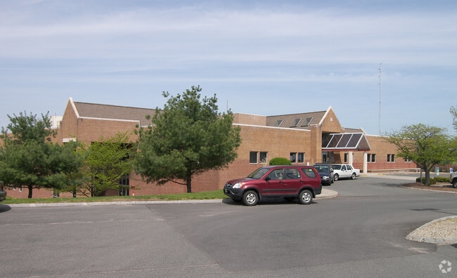

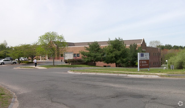

Property Detail
31 Hall Dr
18D 98
HAMPSHIRE
Commercialbuilding
Massachusetts
B and X Area of moderate flood hazard, usually the area between the limits of the 100-year and 500-year floods.
309
2025
6.16 AC
2025
Hampshire County
820700
Hartford
39,182 SF
Amherst Town-Northampton, MA
NEARBY LISTINGS FOR SALE OR LEASE
DEMOGRAPHICS near 31 Hall Dr
1 mile
3 mile
5 mile
2025 Total Population
2,731
31,387
49,420
2030 Population
2,722
31,524
49,573
Pop Growth 2025-2030
(0.33%)
+ 0.44%
+ 0.31%
Average Age
41
33
33
2025 Total Households
1,090
8,213
13,031
HH Growth 2025-2030
(0.28%)
+ 0.50%
+ 0.35%
Median Household Inc
$91,374
$67,153
$72,459
Avg Household Size
2.40
2.30
2.30
2025 Avg HH Vehicles
2.00
2.00
2.00
Median Home Value
$491,578
$455,555
$455,012
Median Year Built
1977
1973
1975
Nearby Places
Map Layers
Map Styles
 Street
 Aerial
Layers
 Traffic
 Biking
Places
Listings with unknown addresses are not visible on the map
- Restaurants
- Banks
- Shops
- Fitness
- Groceries
PUBLIC TRANSPORTATION
COMMUTER RAIL
Drive
Walk
Distance
22 min
9.9 mi
AIRPORT
Bradley International
Drive
Walk
Distance
Bradley International
70 min
39.2 mi
Worcester Regional
Drive
Walk
Distance
Worcester Regional
78 min
43.3 mi
Nearby Properties
Address
Land Use
TOTAL SIZE
Lot Size
Zoning
Address
Land Use
TOTAL SIZE
Lot Size
Zoning
258,531 SF
17.10 AC
Address
Land Use
TOTAL SIZE
Lot Size
Zoning
197,000 SF
22.53 AC
Address
Land Use
TOTAL SIZE
Lot Size
Zoning
108,000 SF
30.85 AC
Address
Land Use
TOTAL SIZE
Lot Size
Zoning
108,000 SF
14.34 AC
Address
Land Use
TOTAL SIZE
Lot Size
Zoning
90,800 SF
12.07 AC
Address
Land Use
TOTAL SIZE
Lot Size
Zoning
45,220 SF
31.01 AC
Address
Land Use
TOTAL SIZE
Lot Size
Zoning
141,603 SF
35.70 AC
B
Address
Land Use
TOTAL SIZE
Lot Size
Zoning
46,138 SF
0.96 AC
Address
Land Use
TOTAL SIZE
Lot Size
Zoning
103,694 SF
0.81 AC
Address
Land Use
TOTAL SIZE
Lot Size
Zoning
18,614 SF
22.20 AC
Address
Land Use
TOTAL SIZE
Lot Size
Zoning
99,483 SF
1.04 AC
Address
Land Use
TOTAL SIZE
Lot Size
Zoning
14,517 SF
34.82 AC
Address
Land Use
TOTAL SIZE
Lot Size
Zoning
12,032 SF
5.11 AC
Address
Land Use
TOTAL SIZE
Lot Size
Zoning
94,415 SF
3.83 AC
Address
Land Use
TOTAL SIZE
Lot Size
Zoning
77,397 SF
0.53 AC
Address
Land Use
TOTAL SIZE
Lot Size
Zoning
5,182 SF
20.70 AC
Address
Land Use
TOTAL SIZE
Lot Size
Zoning
11,657 SF
4.26 AC
Address
Land Use
TOTAL SIZE
Lot Size
Zoning
94,560 SF
1.65 AC
Address
Land Use
TOTAL SIZE
Lot Size
Zoning
6,240 SF
19.93 AC
Address
Land Use
TOTAL SIZE
Lot Size
Zoning
6,064 SF
19.39 AC
Address
Land Use
TOTAL SIZE
Lot Size
Zoning
51,018 SF
0.32 AC
Address
Land Use
TOTAL SIZE
Lot Size
Zoning
2,295.68 AC
Address
Land Use
TOTAL SIZE
Lot Size
Zoning
47,604 SF
2.11 AC
Address
Land Use
TOTAL SIZE
Lot Size
Zoning
16,841 SF
0.88 AC
Address
Land Use
TOTAL SIZE
Lot Size
Zoning
77,103 SF
11.45 AC
B
Address
Land Use
TOTAL SIZE
Lot Size
Zoning
18,520 SF
0.56 AC
Address
Land Use
TOTAL SIZE
Lot Size
Zoning
15,140 SF
8.18 AC
Address
Land Use
TOTAL SIZE
Lot Size
Zoning
37,635 SF
1.06 AC
Address
Land Use
TOTAL SIZE
Lot Size
Zoning
6,000 SF
14.63 AC
The World's #1 Commercial Real Estate Marketplace
Connect with us
© 2026 CoStar Group
The information above has been obtained from sources believed reliable. While we do not doubt its accuracy we have not verified it and make no guarantee, warranty or representation about it. It is your responsibility to independently confirm its accuracy and completeness. Any projections, opinions, assumptions, or estimates used are for example only and do not represent the current or future performance of the property. The value of this transaction to you depends on tax and other factors which should be evaluated by your tax, financial, and legal advisors. You and your advisors should conduct a careful, independent investigation of the property to determine to your satisfaction the suitability of the property for your needs.